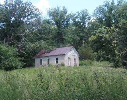
 Miller County Schools Project - Alphabetical OrderMiller County Schools Project - Numeric OrderMiller County Schools Project - Registers and RecordsThe Miller County Historical Society has embarked on a "Miller County Schools Project", in which we will endeavor to document all of the public school districts that were the very basis of our system of free public education for all. As time progressed and transportation facilities developed to the point that travel for a significant distance was practical, a new system of free public schools evolved, based on the consolidation of smaller school districts into one larger school district offering larger schools and more diversified education. This consolidation trend started in the late 1930's and was nearly complete by the late 1950's, bringing to a close the last of the one room schools in Miller County in 1961. We hope that you will join with us in attempting to preserve the history of these schools by adding to our archives information, photographs and reference material on the various schools. We already have a large repository of school board minutes and teachers' registers, and hope to attract the donation of more of these for safe keeping. We also hope to gather more personal stories and class photographs about each school. Additionally, we are compiling lists of teachers who taught there and names of students who were enrolled. It is important to record all of these elements while those who have experienced this system of schooling are still available to make their contributions to these archives. If you have school photos to add to our collection, please click here to upload. Please prepare a text file of information related to the school photos and upload at the same time as your photos. Thank you for adding your piece of the puzzle to the history of these schools. From the outset, the State of Missouri began with a plan. The new and developing United States of America was rapidly spreading to the boundaries of the country as it was defined at that time. In 1803, the U.S. purchased a vast tract of land to the West of the Mississippi River commonly referred to as the Louisiana Purchase. The development of these lands called for a plan that the U.S. had never seen before. The development of land in the Carolinas and the State of Kentucky was haphazard, at best, filled with many abuses and land grabs. Early settlers, including Daniel Boone and related settlers, were cheated of their holdings by land speculators who filed claims against poorly marked or poorly surveyed real estate. As the abuses continued the settlers purchased land and moved into the new lands West of the Mississippi River before the acquisition by the United States government. Without a plan for development, the same abuses would have continued in the Louisiana Purchase. Andrew Jackson, president of the U.S. at the time, was saddled with the task of sorting out new ways to develop these lands without the abuses of the past. Had he not succeeded, it is likely that total anarchy would have occurred in this new frontier. In the lands to the East of the Mississippi River, a survey system called "Metes and Bounds" was the common system and resulted in surveys that were poorly defined, in many cases, after a few years. These surveys were dependent upon a river or stream maintaining its' course forever or a particular Burr Oak Tree with a blaze, remaining forever. The Metes and Bounds survey system was failing. For the Territory West of the Mississippi, a system called the Public Land Survey System (PLSS) was adopted. The basic building block for this system was the survey Township which consisted of thirty-six (36) one mile square blocks of land arranged in a six mile by six mile township. The one mile square of land was referred to a section and each section was broken up into no more than sixteen one-quarter mile squares of land, which amounted to 40 acres each. The forty acre plot or quarter-quarter was the smallest tract of land that was to be sold by the U.S. Government. The U.S. Government set up Land Offices in a number of communities near the sites of development for the purchase of land, and initial sales of a tract of land were registered by the issuance of a "Patent" on the land and a patent document was issued to document that sale. Along with the newly devised survey system, there came a plan for the appropriation of funds for development of local government and a system of public schools, supported initially by the sale of specified portions of the public lands. Section sixteen of every survey Township was designated as "School Lands" with the revenues derived from the sale of that land going to the local government for the purchase of land and construction of buildings to house the schools of that Township. It was mandated that a minimum of four schools be established per survey Township and that they be located as near the center of Sections 08, 11, 26, and 29 as possible. If developed in this manner a school district would consist of one-fourth of a Township, nine sections of land in a three mile by three mile square. The center section of each of these quarters was designated as the location of schools and would mean that no student would have to travel more than two and one-quarter miles from their home to a free public school. The illustration below indicates the plan for development of these system schools. 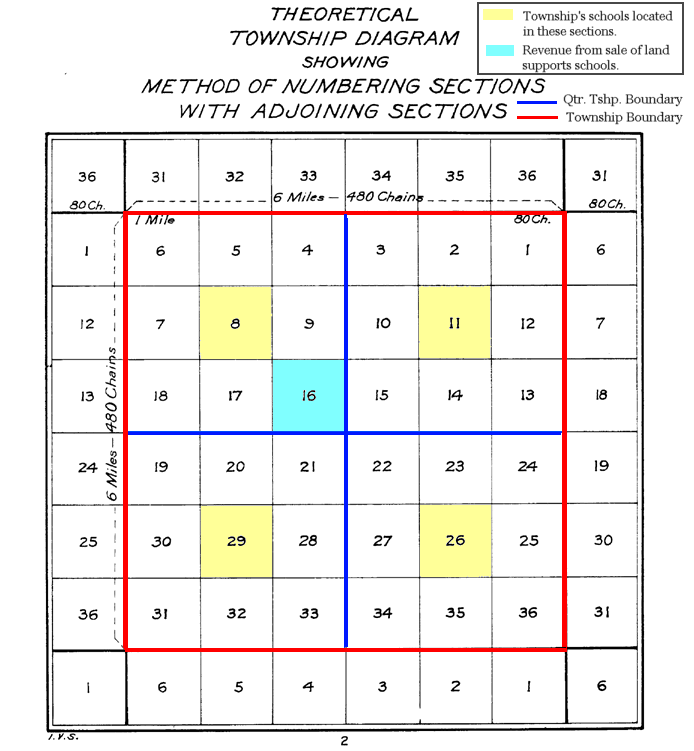 Scheme for development of Public Schools School districts in a county were commonly numbered and the scheme for numbering the schools of the county was similar to that of numbering the section in a survey township. School number one would normally be in the Northeast corner of the county and would then number sequentially westward until coming to the western boundary of the county. The numbering would then move south one row and then continue sequentially eastwardly until coming to the eastern boundary of the county. This process would be repeated until arriving at the last school in the most southern extreme corner of the county. |
|||


|
P.O. Box 57 Tuscumbia, MO 65082 http://www.MillerCountyMuseum.org © 2023 - Miller County Historical Society millercountymuseum@att.net |
|