|
Judge Jenkins' History of Miller County
|
||||||||||||||||||||||||||||||||||||||||||||||||||||||||||||||||||||||||||||||||||||||||||||||||||||||||||||||||||||||||||||||||||||||||||||||||||||||||||||||||||||||||||||||||||||||||||||||||||||||||||||||||||||||||||||||||||||||||||||||||||||||||||||||||||||||||||||||||||||||||||||||||||||||||||||||||||||||||||||||||||||||||||||||||||||||||||||||||||||||||||||||||||||||||||||||||||||||||||||||||||||||||||||||||||||||||||||||||||||||||||||

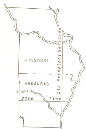 Base Line and 5th Principal Meridian |
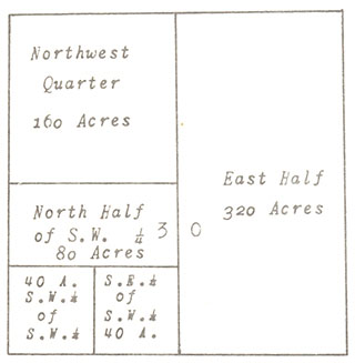 Subdividing Section 30 |
Commencing at the Base line and running East and West at intervals of six miles, lines were established, called Township lines. These lines divided the land, running east and west, into divisions six miles in width.
The Range and Township lines, crossing each other every six miles, formed six-mile squares, called Congressional Townships.
Each Congressional Township was divided into thirty-six, one mile squares, called sections. A section generally contained 640 acres. Each section was further subdivided into fractional parts to suit the convenience of the owners of the land. A half section contained 320 acres; a quarter section, 160 acres; half a quarter, 80 acres; and a quarter of a quarter, 40 acres, and so on.
The survey of land in Miller county were tied to the 5th Principal Meridian, extending north from the mouth of the Arkansas river; and a Base line, extending west from the mouth of the St. Francis river.
The system of land survey established on May 25, 1785, by an ordinance of the Continental Congress, is the legal method of describing and dividing land to this day.
In 1815, the United States Land Office commenced its survey of Missouri, and the meridian upon which all the subdivisions of the State were based was laid out from the mouth of the Arkansas river north to the Missouri river.
Where the Base and Principal Meridian lines met in the State of Arkansas was the beginning point for the survey of all the Public Land in the Louisiana Purchase.
In 1815, Surveyor General William Rector, of the United States General Land Office, sent two surveying parties down the Mississippi river from St. Louis.
Deputy Surveyor Joseph C. Brown, going to the mouth of the St. Francis river, commenced surveying a line due West. Surveyor Prospect C. Robbins, taking his party to the mouth of the Arkansas river, commenced surveying a line due North.
The members of the two parties suffered many hardships while plodding through, and wading in, the muck and slime of unexplored cypress swamps, alive with wild animals of all kind and various poisonous snakes.
Twenty six miles due West from the Mississippi river, in the northwest corner of what is now Phillips county, Arkansas, the surveyors met, in the middle of a cypress slough.
Blazing a young cypress tree with an axe, the members of the surveying parties viewed with satisfaction the beginning point for the survey of more than one-half billion acres of land.
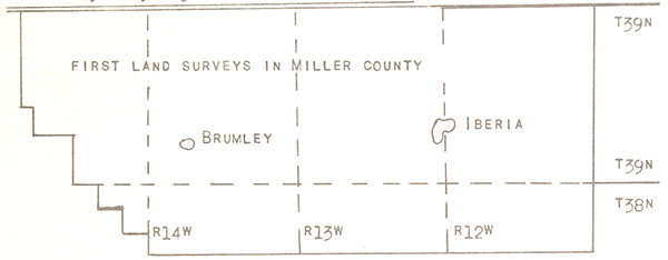
The first governmental land survey in present day Miller county was the North boundary of Congressional Township 39 North of the Base line, Range 12 West of the 5th Principal Meridian. This line was surveyed by Joseph C. Brown in the 2nd quarter of 1816. The west, south, and east boundary lines, and the subdivision lines, were surveyed by Elias Barcroft in the second quarter of 1834.
Surveyed by Angus W. McDonald in 1820 Joseph C. Brown in 1816
Present Boundary of Miller County
The North boundaries of Townships 39 North, Ranges 13, 14, and 15 West were surveyed by Angus W. McDonald in 1820. The other boundaries of these townships were surveyed by Elias Barcroft in 1834. The subdivisions of Township 39 North, Ranges 13 and 14 West, were marked by William Monroe in 1837-38. The subdivision lines of Township 39 North, Range 15 West, were marked by Edwin James and Elvin James, Jr., in 1845.
Townships 40 North, Ranges 13 and 14 West; Townships 41 North, Ranges 13 and 14 West; and Township 42 North, Range 14 West were surveyed by Abner Rector, deputy surveyor for T.C. Rector, in 1821.
Townships 40 North, Ranges 15 and 16 West; Townships 41 North, Ranges 15 and 16 West, and Township 42 North, Range 15 West were surveyed by Elias Barcroft in 1822.
Township 40 North, Range 12 West, and Township 41 North, Range 12 West, were surveyed by James Conner in 1821, and by F.R. Conway in 1849, respectfully.
All boundaries of Townships 38 North, Ranges 12, 13, 114, and 15 West were surveyed by Elias Barcroft in 1834. The subdivisions of Townships 38 North, Ranges 12 and 15 were marked by William Monroe in 1838; with the subdivisions of the same Township, Range 4 West, surveyed by Fernando C. Evans in 1840; and the subdivision of Range 13 West, laid out by Thomas Monroe in 1847.
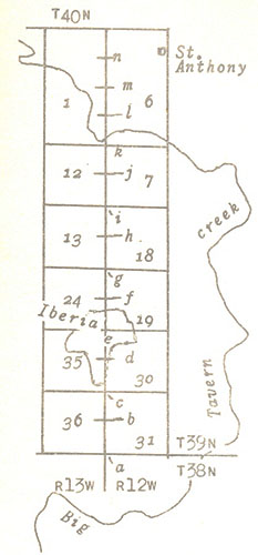
Let us follow Elias Barcroft, deputy surveyor, along the east boundary of Township 39, Range 13 West. This line passes through the present day city of Iberia. It was surveyed on April 19, 1834. Barcroft’s official party included William Stone, Hind chain man; Robert Misee, Fore chain man; Carter T. Craig, Flag man; and William C. Scruggs, Axe man.
Letters of the alphabet, in parentheses, best show locations. In Barcroft’s field notes may be found:
Compared measuring chain with standard measure and found it less than one fourth of an inch too long. Made it the right length and from the last mentioned corner (a) run north along the east boundary of Section 36, Township 39, Range 13 West of the 5th Principal Meridian.
09.67 (Chains) a post oak 16 inches diameter
37.00 a branch 10 links wide runs S.E.
(b) 40.00 Set a lime stone for quarter section corner from which a post oak 16 inches diameter bears S 61 W 35 links and a post oak 16 inches diameter bears N 43 W 144 links distant. Land rolling, pretty good soil, some stony in places and gravelly, but fit for cultivation. A Mr. I. Williams resides about 20 chains southeasterly of this corner. Timber on the above, post oak and black oak. Undergrowth oak, hickory, hazel.
46.50 a draw course east
49.80 a post oak 12 inches diameter
79.00 a draw course east
(c) 80.00 set a sand stone corner to Sections 25 and 36, Township 39, Range 13 West, from which a post oak 16 inches diameter bears S 75 W 42 links and a post oak 14 inches in diameter bears N 63 W 86 links distant. Land hilly, some stony and gravelly soil, rather thin. Too hilly for cultivation. Timber post oak and black oak. Undergrowth oak, hickory, hazel & etc.
North along the east boundary of Section 25, Township 39, Range 13 West.
00.16 a post oak 16 inches in diameter
26.50 a draw course west
(d) 40.00 set a line stone for quarter section corner from which a hickory 16 inches diameter bears S 46 W 21 links, and a hickory 14 inches diameter bears N 74 W 44 links distant. Land 1st 20 chains rather hilly some flinty and gravelly. Balance moderately rolling rich soil all fit for cultivation. Timber black oak, post oak, pin oak, hickory; and undergrowth oak, hickory, hazel, grape vines, & etc.
47.25 an ash 12 inches diameter
54.00 a branch 8 links wide runs N.E.
58.00 southerly side of I. Bellows field of about six acres
65.00 left field; line leaves most of field to east
(e) 80.00 set a flint stone corner to Sections 24 and 25, Township 39, Range 13 West, from which a pin oak 12 inches in diameter bears S 4 W 154 links and a pin oak 12 inches diameter is N 41 W 34 links distant. From this corner the house of I. Bellows bears a little east of south about 20 chains, and the house of George Tolbar bears a little north of west about 8 chains. Land moderately rolling, rich soil, fit for cultivation. Timber, hickory, pin oak, hackberry, ash, elm, and undergrowth oak, hickory, red bud, hazel, & etc. (City of Iberia situated upon this corner)
North along the east boundary of Section 24, Township 39 Range 13 West.
(f) 40.00 set a lime stone for quarter section corner from which a post oak 12 inches diameter bears N 43 W 31 links and a post oak 6 inches diameter bears S 13 W 164 links distance. Land rolling some stony and gravelly, but good soil fit for cultivation. Thinly timbered with post oak, pin oak, and undergrowth oak, hickory, hazel, & etc.
45.50 a draw course west
66.50 a draw course N.W.
75.50 a branch 20 links wide runs N.E. to branch bottom
(g) 80.00 set a flint stone in hazel thicket corner to Section 13 & 24, Township 39, Range 13 West from which a pin oak 12 inches diameter bears N 54 W 155 links distance. No other timber within a reasonable distance for witness trees. Land hilly, barren 1st 35 chains, stony and gravelly, unfit for cultivation. Balance rich branch bottom fit for cultivation. Timber a few small scattering post oaks, white oak, black oak, undergrowth oak, hickory, hazel, & etc.
North along the east boundary of Section 13, Township 39 Range 13 West
01.50 a branch 8 links wide runs east
10.00 a draw course S.E.
29.50 a draw course S.E.
(h) 40.00 set a flint stone in open barrens for quarter section corner. No timber for witness trees in a great distance. Land hilly, some rocky stony, gravelly. Poor barrens, soil unfit for cultivation. Undergrowth oak, hickory, & etc.
52.00 a draw course east
66.50 a draw course, S.E.
(i) 80.00 set a lime stone in open barrens corner to Sections 12 & 13 Township 39, Range 13 West. No timber for a great distance for witness trees. Land 1st 20 chains, hilly, stony, gravelly. Barrens poor soil unfit for cultivation. Undergrowth oak, hickory, hazel, & etc.
North along the east boundary of Section 12, Township 39 Range 13 West
15.50 a draw in a deep hollow
(j) 40.00 set a flint stone in barrens for quarter section corner from which a black jack 8 inches diameter bears N 51 W 507 links distant. No other timber for witness tree. Land hilly, barren, stony and gravelly. In places some good soil but too hilly for cultivation. Undergrowth oak, hickory, & etc.
64.00 foot of hills. Timber and creek bottom. Course east and west.
72.00 a branch 10 links wide
77.25 Tavern creek 100 links wide
79.57 a sycamore 7 inches diameter
(k) 80.00 set a lime stone in low creek bottom corner to Section 1 & 12, Township 39, Range 13 West from which a black walnut 12 inches diameter bears N 53 W 27 links distant. Land 1st 22 chains hilly, flinty, gravely. Barrens poor soil unfit for cultivation. Balance rich creek bottom subject to inundation from 1 to 6 feet from appearance of the timber and drift. In barrens undergrowth oak, hickory, & etc. In bottom timber burr oak, elm, sycamore, undergrowth bush of various kind.
T39N
North along the east boundary, Section 1, Township 39, Range 13 W.
01.00 a slew or part of Tavern creek 30 links wide runs northwest
05.00 out of creek bottom to foot of high rocky hill or rock 15 or 18 foot high nearly perpendicular
33.71 a white oak 36 inches in diameter
(l) 40.00 set a flint stone for quarter section corner from which a white oak 10 inches diameter bears S 11 W 17 links and a post oak 14 inches diameter bears N 50 W 68 links distant. Land some hilly and in place or so very stony and gravelly, but pretty good soil, fit for cultivation. The 5 chains of creek bottom rich but subject to inundation of 3 to 4 feet. Timber in bottom sycamore walnut, elm, and on upland white oak, black oak, post oak, & etc. From this corner a new cabin in which some person lives bears a little West of South about 21 chains distant.
42.69 a hickory 8 inches diameter
52.50 a branch 10 links wide runs N.W.
57.00 a spring branch 8 links wide runs S.W.
59.00 a branch 19 links wide runs S.W.
65.00 an untenanted cabben
66.50 foot of high hill, course N.W., & head of a fine spring runs S.W.
(m) 80.00 this half mile land 1st 26 chains level good soil and passes along and near the easterly side of Tavern creek bottom. Timber white oak, hickory, elm, and etc. fit for cultivation. Balance very hilly, high, steep, rocky and gravelly, poor soil unfit for cultivation. Timber white and black oak. Undergrowth oak, hickory, & etc.
(n) 120.00 this half mile land very hilly. Much of it stony and gravelly. Poor soil, unfit for cultivation. Timber black oak, white oak, post oak, black jack, and undergrowth of oak, hickory, & etc.
147.70 intersected the South boundary of Township 40 N of the base line, Range 12 West of the 5th Principal Meridian. The remains of the old post found and the corners and distances corresponding with the notes furnished me at the surveyor’s office, 19th April, 1834.
By an Act of the Congress of the United States the Public Land in Miller county was placed on the market on the 25th of April, 1820. The first Federal Land Office for this area was located at Franklin.
The settlers journeyed to Franklin by ox-cart, by horseback, by boat, on foot, and by other means to obtain the public land in the territory of which Miller county was afterward made. Certain tracts of land, first offered for sale at the land office, by public auction, if unsold, or any portion thereof, could then be obtained by private entry. After the preemption act of 1841, settlers or squatters upon surveyed land could purchase it within two years without auction. The minimum purchase price for all public land was $1.25 an acre.
The first title issued to a settler on Public Land was called a Patent. When a patent was issued the land passed to private ownership, and an industrious settler labored to wrest the soil from the wilderness.
Howard County was created by Act of the Territorial Legislature, approved on January 23, 1816.
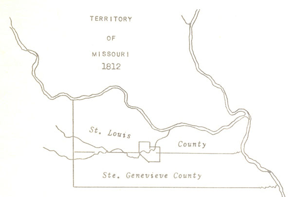
The area of Miller County then formed parts of Howard and St. Louis Counties.
Washington County may have crossed or touched the Southeastern corner.
William Miller entered the first tract of land in Miller county near Spring Garden on July 20, 1826. This followed the treaty with the Indians at Fort Osage by almost eighteen years, and the purchase of the Territory of Louisiana from France by twenty-two years. By a curious coincidence it was also only sixteen days after the deaths of Thomas Jefferson and John Adams on July 4th; the fiftieth anniversary of the Declaration of Independence. Jefferson, having written the Declaration of Independence, was also President when the Territory of Louisiana was purchased from France.
The Jeffersonian era was ending; the Jacksonian era beginning. John Adam’s son, John Quincy Adams, was president. John Miller, of Howard county, serving as Governor of Missouri, found his administration most satisfactory to the people.
The land entered by William Miller was located in Section 23 of Township 42 North and Range 24 West. By 1830, at least sixteen settlers had obtained from the Federal Government a patent on land in present day Miller county. By the end of 1831 at least thirty-six settlers had patented land. These early settlers by name and year of entry included:
William Miller......1826
Boyd Miller......1827
John Vaughan
Reuben Burnett......1829
Stephen Bell
James Bell
Jonathan D. Bills
Benjamin Clark
John Greenup
Daniel Johnson
David Johnson
James Mason
James Stephen
Ebenezer Vernon
Jeremiah Vernon
Edmund Wilkes
Hardin Williams
Evi Ballenger......1830
Willis Brockman
Andrew Burris
William Clark
Alfred M. Houston
John Shelton
Charles G. Stephens
Wyatt Stubblefield
Howell Crews......1831
Esom B. Dooley
Andrew Estes
Samuel Gilleland
Mary Hudson
J.C. McKay
Andrew McCastland
Mahala Musick
Oliver O’Neal
Richard Taylor
Joseph Williams
Louisa V. Nolen (widow)
John M. Bartlett......1832
James Birdsong
William Brockman
Ephraim Clark
John English
David Enoch
John Francis
Hugh Gartin
Melon Moore
Walker Moore
Enoch McCarty
William Hannah
Warner Howser
Elijah Spence
George Shipley
Magnus W. Tate
David P. Taylor
John G. Williams
John G. Witten
T.C . & T.G. Witten
Wilson Allee......1833
Isaac Bass
James Bass
John Clark
Uriah S. Dooley
John S. Franklin
George Greenway
Elihu Gregory
George W. Moore
James Reed
Robert Stubblefield
William Stubblefield
Meredith Bomer......1834
William Brown
Hugh Challes
William L. Gordon
Benjamin Hines
Joel Musick
Joseph Musick
John Rowe
Thomas Sullens
Tolbird Bass......1835
Elbert Baysinger
Marquis Calmes
Wilson Coates
Levi Fowler
Benjamin Cotten
Gabriel Cotten
Daniel Etter
Elisha Francis
William N. Harrison
Samuel Richardson
Owen Riggs
Hiram B. Russell
William A. Shelton
Elijah Spence
John L. Taylor
Isaac Agee......1836
Jacob Barnhart
Metheldred Bass
William Bass
Alexander Beard
Temple E. Bell
James M Bills
Joel Bond, Sr.
Robert Boyd
John Brockman
Sims Brockman
John Brumley
William Burks
Mastin Burris
Hugh L. Campbell
Abraham Castleman
George W. Clark
James Colburn
John DeGraffenreid
T.C. DeGraffenreid
John T. Davis
Henry E. Dixon
William P. Dixon
Asa Elliott
William Elliott
Samuel Etter
John Francis
George King
Daniel W. German
William J. Hale
Andrew J. Harrison
James P. Harrison
John B. Harrison
Samuel T. Harrison
C.C. Houston
Lewis Hughes
Willis B. Jones
Andrew Kingery
Henry Lackey
George Lansdown
John Laurence
John Lumpkin
Jacob S. McComb
Mortimore McKinney
William McKinney
William Monroe
Joseph H. Moore
Gaddis Miller
Jefferson Miller
Samuel Miller
A.G. Musick
David Musick
Leander Musick
Israel Newton
John O’neal
Thomas S. Sarter
Robert Shipley, Sr.
Robert Simpson
Jesse Stark
James W. Stephens
William Stephens
John Sullins
Peter Sullins
A.G. Wilkes
Robert Williams
Alexander Wilson
John Wilson
Samuel C. Witten
Andrew A. Woods
These were the first landowners; the early established settlers.
The war of 1812 ended in 1815. John Wilson, other than a number of Osage Indians, was the only resident in the territory of later day Miller county in that conflict. When the war ended the great rush of settlers to Missouri set in. From Kentucky, Virginia, the Carolinas and Tennessee they came by the hundreds. A continuous stream of settlers passed through St. Louis and St. Charles to the Wilderness in the back country.
The settlers usually brought with them all of their possessions. Sometimes this included a hundred or more head of cattle, beside swine, sheep and horses. Many brought from one to a dozen or more slaves. Three or four yoke of oxen usually pulled a wagon loaded with household goods.
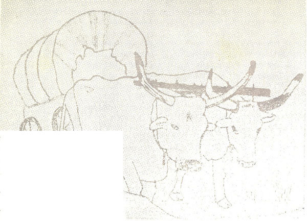
The domestic animal trudged behind, herded by slaves or the elder children of a family. There were no roads, no railroads, or steamboats. In places there were trails to be followed, but only of the most primitive kind. There were no bridges. All streams had to be forded, rafted, or crossed by swimming.
In our imaginations let’s leave St. Louis for Central Missouri with our wives and children riding in crude wagons pulled by two or more yoke of oxen. Only the wilderness is before us. No fences hinder our movement, and the streams, regardless of how wide or deep, have no bridges across them. We lead the way, on foot, worn, but trusted and accurate Kentucky long rifles in hand.
A feeling of panic probably stirs in our minds, for even today, traveling over modern roads, the danger of collision with automobiles removed, this would be an arduous journey.
The earlier settlers did this, and more! They not only traveled into an unknown wilderness, often filled with hostile Indians, but once at their destinations, they immediately opened the wilderness, raised log cabins, and of necessity commenced the preparation of land for the raising of corn and crops of wheat.
Usually the settlers raised their log cabins near springs of clear, flowing water.
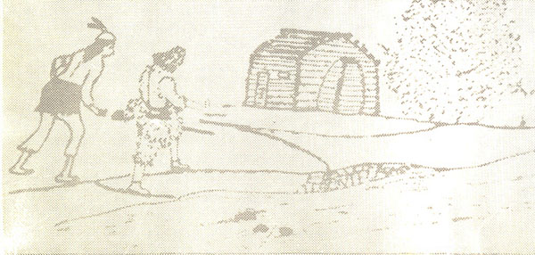
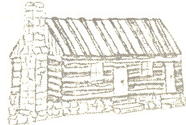
The first houses were made of logs from which the bark was not removed. The cracks and openings between the logs were chinked with mud. These early cabins were merely one room dwellings, having dirt floors. Doors were made by hanging the dried skins of animals over an opening. For cooking and heating fireplaces were constructed of mud and stone. Hammocks of animal skin were used for beds, suspended from cabin ceilings to offer protections from wild animals. It was not an unusual for settlers to be awakened from sleep by noises of wild animals in their cabins searching for food. William West lived in such a cabin by the Big Tavern creek in 1807. He used tables and benches made of logs split down the middle, the flat sides smoothed with an axe. Holes burnt in the half-logs allowed the insertion of sturdy table and bench legs of hickory.
Later, cabins were raised with walls of puncheon logs. These logs were faced and smoothed, and when raised, in building, at each overlap or crossover, the logs were notched and fitted, locking the corners. Cracks in the walls of the puncheon log houses were chinked with small blocks of wood, then filled with mortar made of sand and lime. Solid wooden shutters closed window openings, admitting light only when ajar. Sometimes window openings, especially in the coolness of winter, were covered with greased paper to admit light; the luxury of glass unknown. Doors were made of hewn boards and heavy cross-pieces, hung on wooden hinges. Wooden latches fastened the doors. Latches were lifted by attached draw strings, passed through a convenient hole in the door to the outside. Words of welcome The latch string is always out originated here. Doors were locked merely by pulling the latch string into the cabin. Floors were made of half-logs, the upper sides hewn smoothly, the ends notched into walls, and placed on a level. Fireplaces and chimneys were made of stone, mortared with sand and lime.
By 1837, in the new County of Miller, numerous log cabins with rock fireplaces and chimneys, adorned the countryside.
Until crops could be raised, the settlers kept themselves busily engaged hunting, trapping, and fishing. The forests and the prairies were filled with bears, deers, wild turkeys, squirrels, and rabbits. The flesh of these animals furnished sustenance, with the skins of the deer and bear made into clothing. Wolves, panthers, and wildcats made life exciting. These animals carried away the settlers’ lambs and pigs, and often killed or injured young cattle. There were tales even of babies sleeping in their cradles picked up by panthers and carried away into the wilderness.
The streams were filled with many kinds of fish. In 1835, Pinkney S. Miller, then only eight years of age, caught a fish weighing over 120 pounds. He was fishing in the Saline creek due south from Pleasant Mount. Pinkney’s father being nearby, upon hearing his young son’s cries for help, rushed to his side, and together they landed the monster. William Miller and another man carried the fish home by thrusting a pole through its gills, shouldering the pole. The tail of the fish, even though both men were over six feet tall, dragged the ground.
About this time, two young men named Etter and Bilyeu, fishing in the Wet Auglaize near the line of later day Kinderhook county, caught a catfish of such great size they used oxen to haul it home. They lashed the fish upon two poles, using leather thongs, making a pole skid which was dragged over the ground by a yoke of oxen to the log cabin of Daniel Boone Etter.
William Miller, about 1834, moved from the Spring Garden prairie. He settled on land along the Osage river by the mouth of the Saline creek. According to tradition he raised here a log cabin having only one door and one window. While living here his seven year old son, Pinkney S., chained a bear.
One morning the boy’s dog could not be found. Looking for his pet, Pinkney S. wandered into the forest. In his hands he carried a small chain so his dog when found, could be leashed. Not far from home an old mother bear and two cubs were sighted in the hollow of a large sycamore tree. Soon, mamma bear, leaving her youngsters, disappeared into the forest. Immediately Pinkney entered into the bear’s den. Fastening the dog chain around the neck of one of the little critters he marched to his father’s cabin, his new-found playmate beside him. What was said or done by his father in regard to this act of daring is unknown.
The territory of present day Miller county formed parts of a number of older counties. In the beginning the area was a part of St. Louis, and Ste. Genevieve counties, -two of the five original counties after the formation of the Territory of Missouri. The area north of the Osage river afterward formed a part of Howard, Cooper, and last, Cole county. Maybe Washington, certainly Franklin, Gasconade, Crawford, and Pulaski formed a part of the county south of the Osage river.
By an Act of the General Assembly of the State of Missouri, approved February 6, 1837, Miller county was created; named in honor of John Miller, the fourth governor of Missouri.
John Miller was elected governor at a special election held December 8, 1825. In 1828 he was re-elected governor without opposition. He was born in Berkeley county, Virginia, November 25, 1781. Reared on a farm, he had the advantage of a common school education only. When a young man he located at Steubenville, Ohio, where he edited and published the Steubenville Gazette and Western Herold. He was appointed General of the State Militia of Ohio. During the War of 1812, he held the rank of Colonel in the United States Army. He was assigned to duty under General William Henry Harrison, commanding the Nineteenth United States Infantry. During the siege of Fort Meigs, Colonel John Miller showed his daring and bravery.
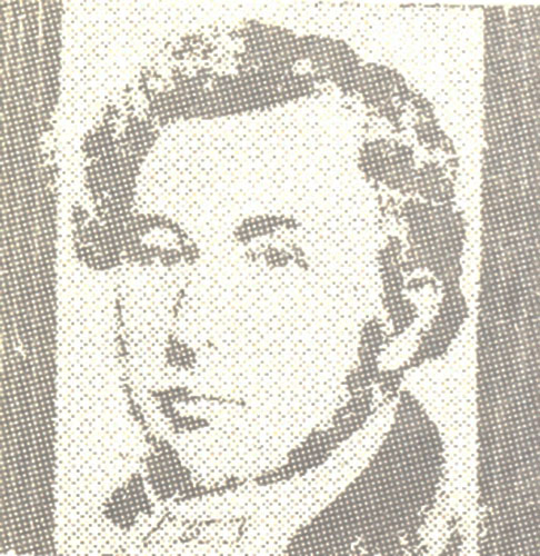
John Miller
The British General Proctor, with all disposable forces under his command, including more than 2000 regulars, Canadian militia, and a large body of Indians under the celebrated Chief Tecumseh, laid siege to Fort Meigs, Ohio, during the months of April and May, 1813. The Indians engaged in the fight upon Proctor’s promise to deliver General Harrison and officers of the garrison to Chief Tecumseh.
On April 26 the British columns appeared on the river bank opposite the fort, establishing their batteries in a commanding position. On the 27th, the Indians crossed the river, immediately placing themselves to the rear of the American lines. On May 1 the bombardment of the fort commenced. Through the 2nd and 3rd an incessant shower of balls pounded the garrison. On the night of the 3rd, the British erected a gun and mortar battery on the left bank of the river, approximately seven hundred and fifty feet from the fort. When this battery fired, the Indians in the vicinity of the fort climbed into trees, and from these vantage points, aggravated the garrison with muskets and arrows.
General Harrison, quickly summoning a Council of War, began asking each Colonel if he could take the battery? Colonel John Miller, believing this an unmilitary like question, answered, I’ll try, Sir! He was given a detachment of 350 men, and they charged from the fort with such great fury, the British and Indians were immediately routed. Capturing the battery, they spiked the British’ gun, returning into the fort with a large number of prisoners.
On July 25, 1814, Colonel John Miller, confronting British General Riall’s army on the high ground in sight of Niagara Falls, advanced upon the enemy with American Generals Brown and Scott. Upon the height nearby, the enemy commenced using their artillery to great advantage. General Brown inquired if Colonel Miller could carry the height and seize the cannon? Quickly surveying the enemy’s position, Colonel John Miller replied, I’ll try, Sir! The height was carried in most gallant style, and determined drives by the enemy to recapture the lost position, were three times repulsed.
Colonel Miller’s words I’ll try, Sir!, soon the motto of his regiment, were ordered stamped upon the buttons of the uniforms worn by his men.
The battle of Niagara or Lundy’s Lane was one of the most obstinate engagements ever fought.
At the close of the War of 1812, Colonel John Miller was ordered to duty in the Territory of Missouri. In 1817, he resigned his commission in the Army to become Register of Lands, which office he held when elected governor. He died March 18, 1846.
Such was the man for whom Miller county was named. A man whose daring at Fort Meigs glorified his name long before elected governor by the people of Missouri.
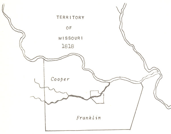
Territory of Missouri - 1818
Franklin County was created by Act of the Territorial Legislature, approved on December 11, 1818. Six days later, an Act approved by the Governor, created Cooper County. Pulaski County, situated wholly within the present State of Arkansas, was created on December 15. When the Territory of Arkansas was created by Act of Congress on March 2, 1819, Pulaski County was removed from the Territory of Missouri; re-established after statehood.
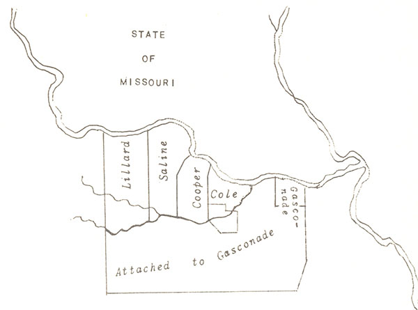
State of Missouri
This is how the area north and south of the Osage river looked when Missouri was admitted to statehood in 1821. Lillard and Cole Counties were created on November 16, 1820; Saline and Gasconade Counties on November 25.
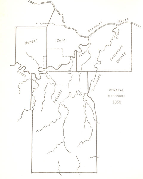
Central Missouri - 1835
The township line between townships thirty-nine and forty, north, extending east and west across the southern half of Miller county, first established by government surveyors for the federal land office, is the reference mark for all public land surveyed in Central Missouri.
Eventually labeled the Base Line, this survey figured rather prominently in the earlier development of the area. It is now the northern boundary of both Glaze and Richwoods townships.
On December 11, 1818, the present area in Miller county south of the Osage river was made a part of Franklin county, then attached to Gasconade county for civil and military purposes on November 25, 1820.
On January 14, 1825, an Act of the General Assembly described Gasconade county’s western boundary as extending from the township line between townships thirty-nine and forty north with the range line between ranges eleven and twelve, to the middle of the main channel of the Osage river. This followed the present eastern boundary of Miller county north from the old base line, or the northeastern corner of today’s Richwoods township.
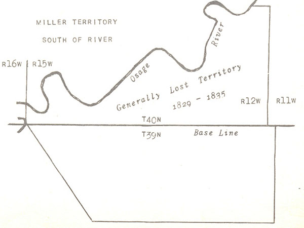
Miller Territory South of River
On January 23, 1829, an Act of the General Assembly, creating Crawford county, established the county’s northern boundary upon the old base line.
This created a situation somewhat peculiar. The territory of present day Miller county, north of the old base line, but south of the Osage river, was lost, more or less, although generally considered a part of Gasconade county.
On January 19, 1833, an Act of the General Assembly, creating Pulaski county, established the county’s northern boundary upon the old base line; leaving the territory north, to the Osage river, unattached.
Finally the General Assembly passed an Act, approved by the Governor on March 17, 1835, which stated: All that portion of territory, lying south-east of the Osage river, bounded on the east by the range line between ranges eleven and twelve west, on the south by the township line between townships thirty-nine and forty north, and on the west by the range line between ranges fifteen and sixteen west, be and the same is hereby attached to the county of Pulaski, for all civil and military purposes.
AN ACT attaching a certain portion of territory to the county of Pulaski.
Be it enacted by the General Assembly of the State of Missouri, [as follows:]
1. All that portion of territory, lying south-east of the Osage river, bounded on the east by the range line between ranges eleven and twelve west, on the south by the township line between townships thirty-nine and forty north, and on the west by the range line between ranges fifteen and sixteen west, be and the same is hereby attached to the county of Pulaski, for all civil and military purpose. This act to take effect and be in force from and after the passage thereof.
March 17, 1835
The Act of the General Assembly, approved February 6, 1837, established the boundaries of Miller county in this manner:
Beginning where the township line between townships forty-two and forty-three crosses the range line between ranges fifteen and sixteen; thence with said range line to where said range line crosses the Osage river the second time; thence up said river until it comes to the point where the township line between townships thirty-nine and forty crosses said river; thence on a direct line to a point on the range line between ranges fourteen and fifteen in the middle of township thirty-eight; thence due east to the range line between ranges eleven and twelve; thence north to the township line between townships forty-one and forty-two; thence with the range line to the middle of the main channel of the Osage river; thence up the middle of the main channel of said river to the range line between ranges twelve and thirteen; thence to the south-eastern corner of township forty-two in range thirteen; thence with the township line between townships forty-one and forty-two, to where the same intersects the range line between ranges thirteen and fourteen; thence with said range line to the township line between townships forty-two and forty-three; thence west with said township line to place of beginning.
On April 6, 1837, Judge William Scott of the First Judicial Circuit appointed James P. Harrison, Clerk of the circuit Court. This appointment made Mr. Harrison the first county official.
On April 13, 1837, Governor Lilburn W. Boggs appointed Edmund Wilkes, John Francis, and Stephen A. Blevans,1 Justices of the Miller County Court. William N. Harrison was appointed Sheriff; William H. Pulliam, Assessor; and Marquis Calmes, County Surveyor.
The General Assembly appointed a Commission of three members to select a site for the seat of Miller county’s government. John Hensley, of Cole county; Zacheus German, of Morgan county; and David Fullbright, of Pulaski county, were the commissioners. Two sites were offered to them, -King’s Bluff, and Harrison’s store.
Harrison’s store was a log trading post, located on the left bank of a slough, now known as the Shut-In branch, in the midst of a dense forest, by a big spring.
The commissioners selected Harrison’s store as the place for Miller County’s Permanent Seat of Government on April 17, 1837.
On May 1, 1837, the first session of the County Court was held in the log house of William Miller by the Osage river, near the mouth of the Saline creek. The first entry in the County Court Record Book was recorded in this manner:
County Court May Term 1837
At a County Court held at the house of William Miller in the County of Miller and State of Missouri on the first day of May in the year of Our Lord Eighteen Hundred and Thirty Seven, present the Worshipful John Francis, Edmund Wilkes, and Stephen A. Blevans, Justices of said Court; William N. Harrison, Sheriff; and James P. Harrison, Clerk. It is ordered by the Court here that John Francis be appointed President of said Court for the term of one year. Ordered Court adjourn until the following morning.2
So the County of Miller, named after Governor John Miller, the fourth Governor of Missouri, was a full-fledged unit of government. On the second day of the May Term, the County Court got down to business, organizing the new County.
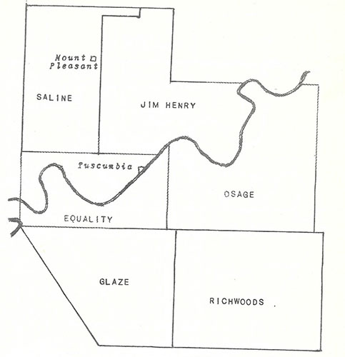
The court divided Miller county into four municipal townships. These townships were named Saline, Osage, Richwoods, and Equality.
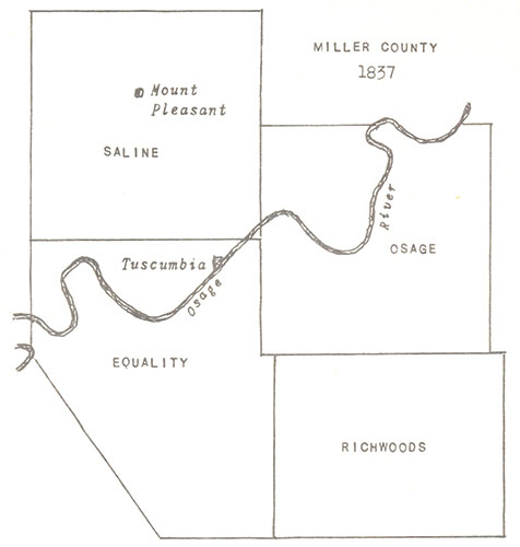
Miller County - 1837
The County Court divided Miller County into four Municipal Townships, on May 2, 1837.3 Each township was an election precinct with places of voting as follows: Saline Township, Mount Pleasant; Equality Township, Tuscumbia; Osage Township, at the house of John T. Davis; Richwoods Township, at the house of Zachariah Price.
1. Stephen A. Blevans was a former Justice of the Pulaski County Court
2. County Court Record Book A, page 1
3. Ibid.,, pages 1 & 2
(Filed for Record August 28, 1837)
To the honorable County Court of Miller County, We, your petitioners feel ourselves agrieved by having to cross the Osage river to get to our electing precinque. We, therefore, pray and your worships to grant us a township as follows, to wit, beginning on the Osage river where the range line between 13 and 14 crosses the sed river thence south with sed line to where it strikes the county line, thence westerly with the county line to the Osage river, thence with the main channel of sed river to the beginning and our electing precinque to be at Wm. Bilyeus. We your petitioners ever pray Ɛ¢ Ɛ assigners our names1
|
Silas Capps Abraham McCubbin Robert Reed Champ Tankford Carter William Kinder James Record John Record George W. Bilyeu Miles H. Burris Giddean Long John McCubbin William King Bryan McClendon Samuel C. Jones |
James Reed John Davis Thomas McCubbin William McCubbin T.J. Armstrong W.C. Armstrong Isaac Bilyeu Joel Thacker Wm. Bilyeu Wilburn Robins Jefferson Nicles Noah Hudson Arron Puybaum Jesse McClendon David Winningham |
1. The Township of Reed was established by this petition
(Filed for Record November 6, 1837)
To the Honerable the County Court of Miller County in the State of Missouri. We, the undersigned petitioners inhabitance of the Township of Reed in the County aforesaid Humbly represent to your Honor that at the August Term of the County Court of this county the Township of Equality was divided so as to form a new Township in said county known by the name of Reed Township in which Township it was our unhappy lot to fall and finding the same intirly in compatible with our interest.
We, therefore, pray your honorable body to attach said Township Reed back to Equality as it once ware as it is adding additional ecpense to the county and not promoting the interest of the county as we all wish to come to our county seat frequently and can attend elections at that place better than pay the taxes necessary to be laid upon us for to defray the expence of the Township. That these your petitioners reasonably request may be expecially granted they will ever pray Ɛ ¢
|
Cornelius P. Davidson William R. McCubbins Thomas Davidson Abraham Osteen John Davidson Edward Carter Andrew Bilyeu Enoch McCarty |
William King James Watson Robert Reed John Davis Jacob Davis James Reed Sherwood P. Record |
For the purpose of electing four Justices of the Peace, and one Constable, in each township, the County Court ordered an election in each township be held on the first day of July.
The County Court ordered Sheriff William N. Harrison to get one table five feet long and four feet wide with two drawers in the same three feet wide, with good locks and keys, and five good straight chairs. This furniture was to be made of good indurable materials and well constructed in a good workmanlike order. The Clerk of the Court, J.P. Harrison, was ordered by the County Court to get a suitable desk in which the county’ papers could be safely kept.1
The Sheriff purchased six chairs for $7.25. The Clerk of the Court purchased a desk, made by John S. Lumpkin, for $29. The table for the County Court was constructed by William Clark. When he presented a bill of particulars for $10, the County Court found this to be exceedingly high, and allowed him only $8.
For two days attendance at the May Term of the County Court, 1837, Sheriff William N. Harrison was allowed the sum of three dollars; John Francis, President of the County Court, four dollars; Stephen A. Blevans and Edmund Wilkes, Associate Justices, each four dollars.
1. County Court Record Book A, page 3
On the Nineteenth day of June, 1837, the County Court met in a log building near the trading post of J.P. Harrison and brother, the place previously selected for the county seat.1 Letters of administration were granted on several estates, with demands against these estates the main order of business. Merchants and grocers licenses were issued to William P. Dickson & Co.; Andrew Burress & Co.; Zachariah Price; and the next day to J.P. Harrison and brother. A merchant’s license cost ten dollars for six months, a grocer’s license five dollars. Elisha Francis was appointed County Treasurer by the Court, and bonded for $1,000.
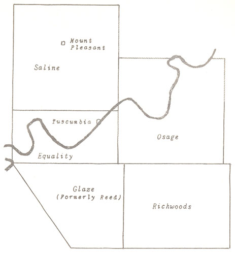
On August 28, 1837, William Bilyeu and sundry inhabitants petitioned the County Court to form the Township of Reed, with the schoolhouse near the settlement of John Davis in the Little Richwoods as the place for the holding of elections. Immediately established by the Court, this township existed little more than two months, for on November 6, 1837, Jacob Davis, with others, petitioned the County Court to attach the Township of Reed back to Equality, which was done.2
On May 7, 1838, the County Court established the Township of Glaze, using Reed’s old boundaries, with the house of Daniel Etter designated as the place for the holding of elections.3
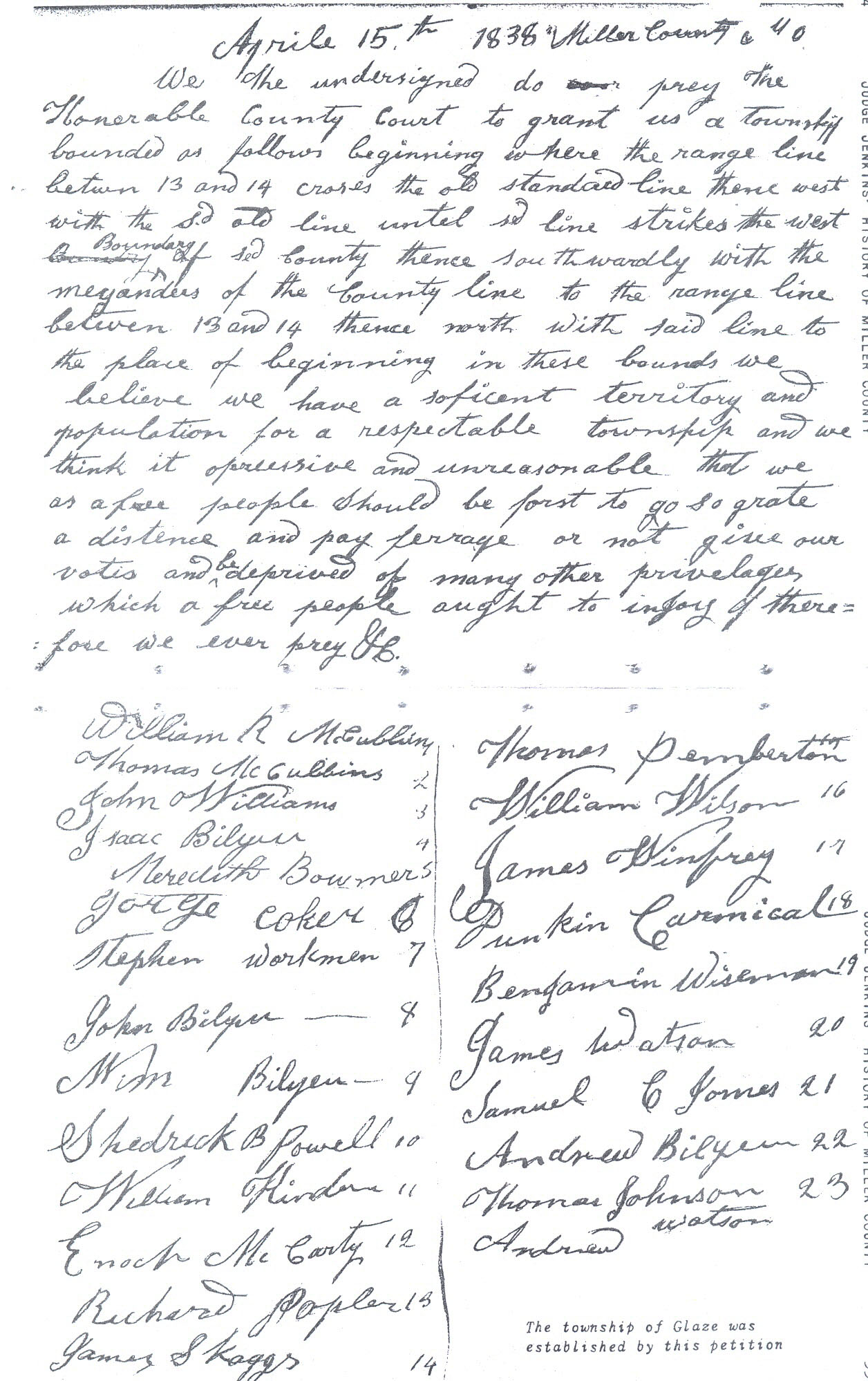
The Township of Glaze was established by this petition
Click on the above image for a larger view
The people in Osage township experienced considerable difficulty in crossing the river during elections, and conducting township’ business. They sought a remedy. On October 18, 1837, sundry inhabitants petitioned the County Court:
To the onorable cort of miller county -when setting
Gentlemon –we the under subscribers do pray this onorable cort to grant us an Election Held on the East side of the osage river near the center of our settlement and township for this purpose of Electiong in Justices of the Peace and a constable -We consider it to be our rights As we labour under great disadvantages being cald from twelve to fifteen miles to other townships to do business –and we your humble petionors Do further Assign our nams
|
Robert Boyd Samuel W. Parkes John McGlaughlin William Wade John Millholland Jacob Barnhart James Farmber Willis Wilson John Wilson William Wilson |
Hugh Snelling John Clark James Snelling Jacob W. Manus J.A. Manis Greenville Boyd Martin Farley James Boyd J.L. West |
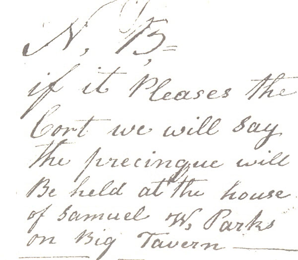
On November 5, 1838, Jacob Manis petitioned the County Court to establish a township and election precinct south of the Osage river, in Osage township, because inhabitants on the southern side were having great difficulty crossing the river to attend township meetings and elections.
The petition stated: We the people of osayg township we pray your honorable boddy to give the citizens of osag a township on the south east side of the osag river and give us a pre Sinque in our settlement as we need some Justices of the peas in this town ship and one constable we pray your honorable boddy, we pray your honorable boddy. We the citizens think it suitably to have a presinque at Samuel W. Parkes on big tavern.
|
T.W. Whitaker Benjamin Hamelton Samuel W. Parkes Jacob Manes William H. Wade P.D. Hackleman Levi Millholon Willis Wilson Robert Boyd |
John Millhollen Greenville Boyd J. McGlaughlin William Wilson James Farmber Martin Farley William West David Mclain John Wilson Jac Wimmer |
This petition was honored by an entry of Record it is thought expedient by the Court that the Township of Saline be divided, and the Township of Osage be divided, and a new township formed, to be known by the name of Jim Henry.4
The County Court designated the house of John Walker as the place for the holding of elections in the Township of Jim Henry, and moved the voting place in Osage township from John M. Wisdom’s cabbens on the Osage river, opposite the mouth of Panther creek, to the house of Samuel M. Parks, on the Big Tavern Creek.
1. County Court Record Book A, page 3
2. Ibid.,, pages 16 & 18
3. Ibid., pages 29, 30
4. Ibid., page 42
On July 1, 1837, the first election in Miller county was held. Justices of the Peace and a Constable were elected in each Municipal township. In Saline township the election was held at the store of Andrew Burress. The judges of election were John S. Franklin, Hiram B. Russell, and Andrew McCasland.
In Equality township the election was held at Tuscumbia. Here, for the first time, the name Tuscumbia may be found in the Record book of the County Court.1 The judges of election were James Reed, D. Boqua, and Hugh Challes.
In Osage township the election was held at the home of John T. Davis. The judges were William Miller, John Witten, and John T. Davis.
In Richwoods township the election was held at the store of Zachariah Price. The judges of election were James Scott, William Biyze, and Josiah Stuart.
In Saline township Hugh L. Campbell, Hiram B. Russell, and Hugh Gartin were elected Justices of the Peace, with John S. Franklin elected Constable. In Equality township John Francis, Sherwood P. Record, Andrew Boqua, and Elisha Francis were elected Justices of the Peace, with John Davidson, Constable. Justices of the Peace elected in Richwoods township were Jesse Kendrick, Peter Bilyeu, Josiah Birdsong, and James Scott. No entries may be found in the Record of the County Court, or the Commission Record showing the result of the election in Osage township. The reason for this is unknown.
1. County Court Record Book A, page 2
Alfred M. Houston was appointed Commissioner of the Seat of Justice for Miller county.1 The County Surveyor, Marquis Calmes, was ordered by the County Court to survey the exterior boundaries of the land donated to the county by James P. Harrison for the Seat of Justice. The survey was to particularly note the existence and direction of the principal ridge in the donation, with the meandering of the Osage river and the Shut In branch fully considered in laying out the town to the best advantage.2
On July 11, 1837, the County Court ordered the Seat of Justice in Miller county named Tuscumbia.3
1. County Court Record Book A, page 2
2. Ibid., page 8
3. Ibid.
Of the approximately 3000 counties in the United States only three have the name of Miller. These are located in Missouri, Arkansas, and Georgia. Only one other town in the United States is named Tuscumbia. The name is derived from the Chickasaw word TashkaAmbi, meaning the Warrior who Kills. How Tuscumbia, Missouri, got its name is purely speculative, but most historians believe Tuscumbia, Missouri was named after Tuscumbia, Alabama.
It is almost certain the name Tuscumbia was suggested by William P. Dixon. He settled on the northern prairie in the 1820’s and started the first store in the territory later Miller county. William P. Dixon and William Miller named the area or settlement in which this store was situated, Spring Garden.
William Miller, instrumental in the formation of Miller county, before the county’s organization, moved to the mouth of the Saline creek from the Spring Garden prairie. Here without any doubt, his former neighbor, William P. Dixon, visited him often when traveling by ox-wagon to pick up goods and freight for his Trading Post on the prairie at the Spring Garden Landing near the mouth of the Saline creek, or up-river at Harrison’s Landing, near the big spring.
On December 14, 1836, William P. Dixon made an entry on land in Section 24, Township 42, Range 14. Here his name was spelled Dickson. On August 6, 1838, he was elected Clerk of the Circuit and County Courts, holding the office for sixteen years.
Mr. F.R. King, of Tuscumbia, Alabama, a man well along in years, and a local historian of note, in the 1930’s furnished the following story, which was printed in the Miller County Autogram by Editor L.A. Wright.
In 1817, at the village of Reyoldsburg, Tennessee, there occurred an awful tragedy. The Creek Indians burned and sacked the town, and few there were who escaped death. Among those who did were Michael Dickson, his wife, and four sons. Mr. Dickson’s father-in-law, an old man, viewed the situation as an ugly one, so hastily summoned his son-in-law and family and suggested they leave the place at once. All agreed.
They quickly obtained a keel boat and loaded all they possessed into it. Immediately they began an arduous journey up the Tennessee river, to a country about which little was known at that time. For days they labored, until time went into weeks, but at last they wee pleased with the surroundings. In the late evening they pulled to shore at the mouth of Spring Creek, two miles from the Big Spring, now Tuscumbia. The Big Spring was situated a quarter of a mile from where it flowed into Spring Creek, one and three-fourths miles from the Tennessee river.
During the night they pushed to the head of the Big Spring. The next morning, old man Dickson met and smoked the peace pipe with the Cherokee Chief, Tuscumbia. The Dickson’s always said the old Chief was a good, genial man, but like most of his tribe, not a good financier. Mr. Dickson drove a trade, a bargain, with the Chief by which he acquired all the land from the mountain south of the Big Spring two miles, to the Tennessee river. This tract, with a four mile frontage, even in those early days, was a vast amount of land. Mr. Dickson gave Tuscumbia five dollars in silver and two pole axes, and often said it was the best trade he ever made.
In 1818 there came into the Dickson’ family a little girl, whom the parents named Annie. She was the first White child born at the Big Spring, Alabama.
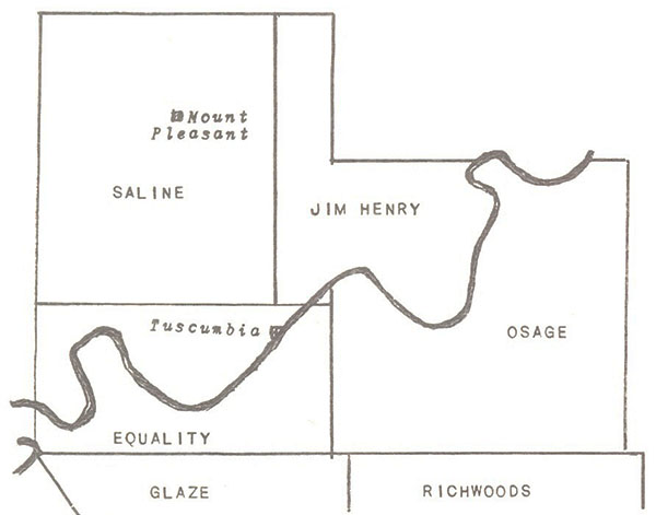
On February 3, 1845, a number of citizens in Jim Henry and Saline townships petitioned the County Court to annex a portion of Saline township to the Township of Jim Henry.1 The change, allowed by the Court, is shown above.
In 1859 the County Court ordered all of the Township of Jim Henry situated in Congressional Township 42N, Range 14W, stricken, and attached to the Township of Saline.2
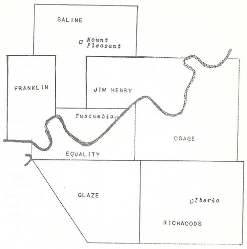
On May 7, 1860, a new township was formed by the County Court which included territory obtained from Morgan county. The Township of Franklin was established, with the house of David Wadley as the place for the holding of elections. On March 19, 1862, the place for the holding of elections was changed from the house of David Wadley to Blue Spring.3
In 1820, a few White settlers had drifted in, and they began to feel the need of a name for the new White settlement whereby they could have a post office, being inconvenient to travel thirty six miles back and forth to Russellville, Ala., to get a letter or post one. It was suggested an election be held with the names of little Annie Dickson and that of Chief Tuscumbia voted on, with the one receiving the most votes having the honor of the town named for him or her. Chief Tuscumbia, winning by one vote, was so delighted by being thus honored he had a pair of beaded buck-skin slippers made for little Annie. On December 3, 18i22, the name of the settlement was changed from Big Spring, to Tuscumbia, Alabama.
Returning to Miller county, it may be found the County Seat at Harrison’s storehouse was officially named Tuscumbia on July 11, 1837, approximately fifteen years after the official birth of Tuscumbia, Alabama.
1. County Court Record Book A, page 206
2. County Court Record Book B, page 711
3. County Court Record Book C, pages 185, 385
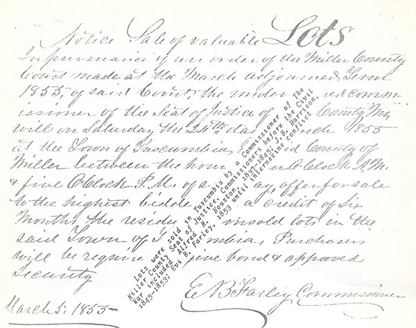
On July 29, 1837, the County Surveyor, Marquis Calmes, had the exterior boundaries of the town of Tuscumbia completely marked out. Here, apparently at odds with the County Court, he resigned. James P. Harrison immediately executed a deed to the county of Miller for fifty acres of land.1 On August 28, 1837, Alfred M. Houston, Commissioner of the Seat of Justice, presented a plat of the town of Tuscumbia to the County Court.
Commissioner Houston offered certain lots in the town of Tuscumbia for sale on October 9, 1837. The sale of these lots, advertised in a Jeffersonian newspaper, was upon terms specified as one-fourth of the purchase money in cash and a credit of twelve months on the balance. Fifty one lots were sold for six hundred and eighty three dollars and 86 ¼ cents.
For Labor, and money expended in having the town of Tuscumbia laid out, the County Court allowed Commissioner Houston $164.93 ¾. Marquis Clames, ex-County Surveyor, for services performed prior to his resignation from office, was allowed $10 only; the Court finding his account for $11.81 ¼ unjust.
1. County Court Record Book A, page 10, 11, and 12. Tuscumbia officially established on July 29, 1837
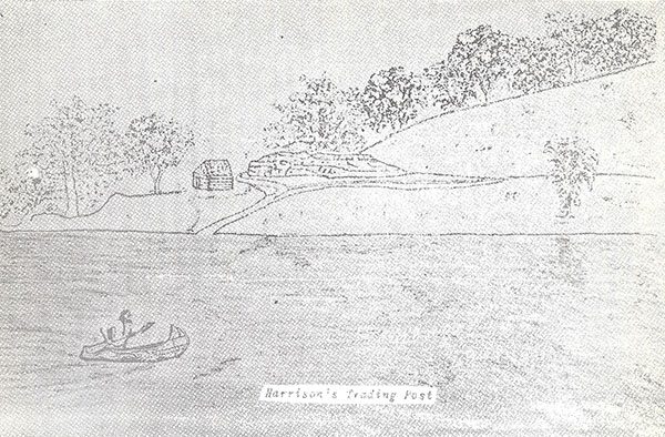
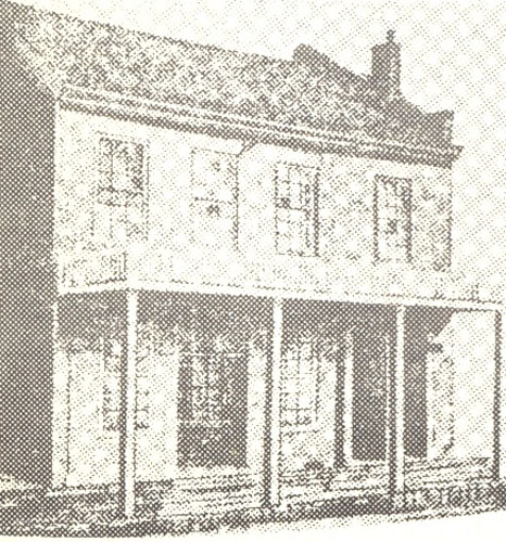
Harrison's Trading Post
Lots Sold in Tuscumbia
When J.P. and J.B. Harrison, two bachelor brothers, raised their log trading post on the left bank of a slough by a big spring, in the early 1830’s, the Osage Indians were their regular customers. Remembering this, J.P. Harrison, in the original survey of the County Seat, reserved a plot of ground for the Indians to camp upon when in the vicinity of Tuscumbia. Harrison’s Reservation, situated upon the north bank of the Shut-In branch by the river, was a small, triangular area upon which Hauenstein’s old store building is standing today.
The second place of business in Tuscumbia after Harrison brothers, a saloon, was opened by Squire Jesse Kendrick. Upon his demise, he was buried by an elderly negro slave. A tombstone upon the bank of Shut-In branch marked his grave until recent years.
A hatter’s store, Josiah Birdsong, proprietor, was early an enterprise of importance at the County Seat.
In 1844, between the bluff and the big spring, Daniel Cummings erected an immense building for that era; later, building the Tuscumbia hotel where the Presbyterian church now stands. Mr. Cummings and J.B. Harrison engaged in the merchandising of goods and groceries in the first building, with Emmanuel Godlove, proprietor, of the Tuscumbia hotel.1
1. Emmanuel Godlove was the first person in Miller county to file an intention of becoming a naturalized citizen.
On February 7, 1838, the County Court appointed Alfred M. Houston to superintend the building of a house for the County of Miller. The County Court specified the building would be a hewed log house thirty five feet from outside to outside. In width twenty feet from outside to outside, with a log partition wall in it placed so as to make one room of the building square. The logs to be hewn seven inches thick to face twelve inches in the middle and to be of good sound durable timber. To be raised at least twelve inches above the highest part of the ground on which stands, or is to stand. The house to be placed lengthwise North and South parallel with the streets of the town of Tuscumbia, and put upon good stone pillars and well underpinned with stones; with one good stone chimney; fire place four feet wide. Chimney to be at the north end of the building. Sleepers to be placed two feet apart from center to center and of size sufficient to make a good steady floor. Floors to be made of good sound oak plank inch and a quarter thick, common width, not dressed, but to be jointed and well nailed down, well in workmanlike manner, well ceiled under joists. Four good batten doors, a good and sufficient lock to each door. Four twelve light windows, lights eight by ten inches, two windows to each room. Large room to be in the north end of the building. To be chinked and pointed with lime, house and chimney, both house inside and outside. The wall to be ten feet above the top of the sills; a good shingle roof, shingles well nailed on sheeting. Shingles four inches wide and eighteen inches long. Said building to be put upon lot number twelve in block numbered 23 in the town of Tuscumbia as laid down in the plat of said town, and to be completed on or before the 25th day of October next. And the Court doth further order that the said Commissioner let the building of the said house out at the lowest bidder on the 25th day of March next at Tuscumbia, and that he advertise the same at one of the most public places in each township in this county; all of which work is to be done in a good workmanlike manner.1
The next day, the County Court appropriated $400 for the purpose of having a courthouse raised on Lot 12, in Block 23, upon the hill in Tuscumbia, from monies obtained on the prior sale of town lots. However, a usable courthouse was still three and a quarter years away.
1. County Record Book A, page 25 & 26
On February 6, 1837, Miller county was created. Two days later, on the 8th, Andrew Kingery and Elizabeth Degraffenreid were married by Yehatan Melton, a Justice of the Peace. Andrew Kingery, a preacher of the gospel, on February 26, joined Sims Brockman and Rachael Gartin in bonds of holy matrimony; the second marriage in Miller county.
Five other marriages were recorded in 1837, Abel W. Armstrong and Malinda Ferguson were married by John Francis, one of the Justices of the County Court, on July 4; James Armstrong married Katherine Reed on August 1; Julius Nichols married Margaret Davidson, on September 26.
William Bond and Sarah Sullens were united in marriage on November 7, Squire Hiram Russell performing the ceremony. On November 9, Mortimer Brashear and Sarah Vaughn were married by Stephen A. Blevans, a Justice of the County Court.
In 1838, thirteen marriages were solemnized in Miller county.
Courting was a difficult thing in earlier days, accomplished by the younger folk visiting in the homes of neighbors over week-ends or at Church on Sunday. Divine services, since there were few church buildings, were often held with preaching in brush arbors under the trees.
In the early Autumn of each year protracted meetings provided an opportunity for the younger folk to really get together. These meetings, lasting a week or more, with preaching in the morning and afternoon of each day, were attended by families from many townships. During the noon’ hour, the womenfolk, uncovering baskets well-filed with food, spread huge dinners over cloths placed upon the ground, where boys and girls, having romance in their hearts, could sit near the arbor’s edge and lunch together, away from the critical glances and chastising tongues of their elders.
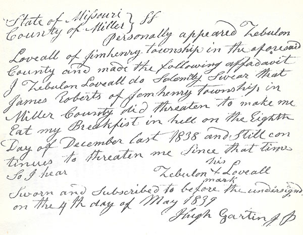
On November 6, 1837, Squire Jesse Kendrick settled a dispute between two of Miller county’s distinguished citizens. Whether involved over differences in religion, wine, women or politics is not known. Squire Kendrick fined Joshua Davis and Cornelius Roberts, in a case of assault and battery, the sums of four dollars, each, but Zebulon Loveall and James Roberts kept talking about this affair until after Christmas.
In 1837, William P. Dixon and Co. paid $51.82 in taxes for state and county purposes; Andrew Burris and Co., $50.31; J.P. Harrison and brother, $49.09 1/3; and Zachariah Price, $18.12 ½. This was the beginning of business in Miller county.
Three grist mills –Bilyeu’s on the Big Tavern creek northeast of Iberia; William Brockman’s on the Saline creek at Sulphur Spring; and Sarter’s on the Saline creek near today’s residence of Judge Paul Martin. The Brockman’ mill, constructed in 1833, was the first mill in the county to be driven by water power. This was the beginning of industry in Miller County.
In earlier days rail fences around cultivated fields merely kept cattle, swine, and other wild and domestic animals out, not an inhabitant’s livestock in. Domestic animals ran with the wild ones, at large. The acorns and nuts in the forests, called mast, fattened the hogs; with lush grass in the valleys and upon the prairies furnishing sustenance for livestock. This made it necessary for domestic animals to be marked or branded.
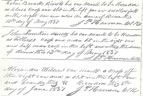
To determine ownership, two books, Marks and Brands, and Strays, were kept at the County Seat. The first entry in the book of Marks and Brands was made by Reuben Burnett giving notice his mark was a crop and slit in the left ear and a swallow fork in the right ear of his animals, on May 12, 1837. In the book of Strays the first entry stated We, the undersigned appraisers, appointed and duly sworn to appraise without partiality, favor, or affection, a certain horse taken up as a stray by Elihu Gregory and brought before Hiram B. Russell, Esqr., a Justice of the Peace, within and for Saline Township, Miller county, do certify that we have viewed said stray and find him to be a black horse, four years old, fifteen hands high, a white spot on his back about the flank. No other marks or brands foreseeable, and do appraise said horse to the sum of fifty dollars. Certified under our hands this 27th day of May, 1837. David Enoch and William J. Hale, Appraisers.
Circuit Court in Miller county was held first at the log house of William Miller near the mouth of the Saline creek, by the Osage river. The Circuit Court Record Book commenced:
At a circuit court begun and held at the house of William Miller within and for the County of Miller in the State of Missouri on Thursday the Twenty Second day of June in the year of our Lord One Thousand Eight Hundred and Thirty Seven (it being the Thursday before the fourth Monday of said month) were present William Scott, Judge; William B. Napton, Attorney General; James P Harrison, Clerk; and William N. Harrison, Sheriff of said county.1
In Pursuance of a writ of venire facias to him directed, the Sheriff returned into court the following panel of a Grand Jury; the first summoned in Miller county: John T. Davis, foreman, Jacob L. Loveall, Abraham Castleman, Leander Musick, Peter Sullens, John Shelton, John Hale, John Steward, William Blyze, James Brumley, John G. Witten, Elihu Gregory, Elisha Francis, Isaac Bass, Samuel Miller, William P. Dixon, and Robert Shipley.2 This grand jury returned no indictments.
Sherwood P. Record, Isaac Bilyeu, Robert Boyd, Willis Wilson, and Andrew D. Boqua, failing to appear, were fined for contempt of court a sum of five dollars, each.
The members of the first petit jury were Gaddis E. Miller, William Miller, Jonathan Blevans, Stephen A. Blevans, Thomas Dawson, Enoch McCarty, Peter Bilyeu, Samuel Gilleland, Tscharner Degraffenreid, John K. Degraffenreid, David Musick, and Joel Musick.3 The first trial heard by a jury was an appeal from a justice court with Oliver O’neal against Richard Taylor on a charge of trespass. The jury, finding the defendant guilty, awarded the plaintiff damages of one cent.
On October 26, 1837, Judge William Scott convened Circuit Court at the house of William Miller a second, and final time. Grand jurors were Benjamin Hinds, foreman, John R. Bilyeu, Thomas Davidson, William King, William F. Henderson, Benjamin Capps, Uriah S. Dooley, Noah Hudson, Talbot Bass, Edward Carter, James Armstrong, John Lumpkin, Mortimer McKinney, Cornelius Roberts, Josiah Birdsong, John Brumley, James Thompson, Boyd Miller, Jonathan Wilkins, Jeremiah Curnutt, and William J. Hale. Samuel C. Jones, one of the jurors failing to appear, was fined for contempt of court a sum of $5.
1. Benjamin M. Lisle, John McCullough, and Edward L. Edwards produced in Court their licenses to practice as attorneys, Circuit Court Record Book A, page 4
2. Circuit Court Record Book A, page 1
3. Ibid.
At this sitting of the Court, Judge Scott received a notice from the County Court, and upon adjournment, proclaimed:
The Seat of Justice of Miller County has been established according to law. The County Court of said county determined at the July Term of said Court in the year Eighteen Hundred and Thirty Seven that the Court for said county should be held at Tuscumbia, the Seat of Justice for said County of Miller, and notified this Court accordingly. It is therefore ordered the Sheriff make proclamation at the Courthouse door that this Court will hereafter be held at Tuscumbia…
On Thursday, February 22, 1838, Circuit Court was held for the first time in Tuscumbia, by the storehouse of J.P. Harrison and brother.1
1. Circuit Court Record Book A, page 6
Indictments first returned by a Grand Jury, on April 1, 1839, were for adultery, felonious assault, and vagrancy. Then, on June 1, 1840, the County Court ordered no further compensation to grand jurors. Ten years later, this order was rescinded.
As previously noted the first trial jury awarded one cent in damages. So did the second. This was in an action of replevin for the detention of negro slaves, between Thomas H. Dawson and David Musick. The plaintiff, Thomas Dawson, was awarded damages of one cent. On February 23, 1838, at the first term of Circuit Court in Tuscumbia, a charge of slander was tried before a jury with Jane Mason, by her guardian, against George W. Claybrook. The jury, upon finding the defendant guilty, again awarded the plaintiff damages of one cent.
However, Judge William Scott was rather reluctant to engage in games of penny-ante. He fined John Thomas and David Enoch for contempt of court, a sum of five dollars. Both men, in the immediate hearing and view of the Judge, having made loud noises, interrupted the Court’s proceeding. William Claybrook, George W. Claybrook, William F. Lawson, and Jeremiah Stubblefield, having engaged in very loud conversation during the Court’s sitting, were fined for contempt of Court a sum of five dollars. Leander Musick, having stood before the jury to its interruption, upon being ordered to stand back and move away by Judge Scott, shouted insolent language at the Court. Immediately he was fined $20, and committed to the custody of the Sheriff.
At the June Term, 1838, this entry may be found: John Scott having this day in the presence of this Court contended with hot and angry words with David Enoch and threatened to kill the said Enoch; the Court doth therefore order the said John Scott enter into a recognizance to the State of Missouri in the sum of $500, with one or more sufficient sureties, conditioned he will keep the peace towards the people of this State and particularly toward David Enoch for the space of six months. Unable to find sufficient security, Scott was committed to the custody of the Sheriff.
The next morning, with nine citizens of Miller county acknowledged as indebted to the State of Missouri in his behalf, upon his promise to leave David Enoch unmolested for six months, the Court reduced John Scott’s recognizance bond to fifty dollars, and released him from the Sheriff’s custody.
It seems a lot of serious fighting occurred between some inhabitants of Miller county for several years. Many recognizance bonds may be found in the Circuit Court record, conditioned that two or more persons keep the peace toward the people of this State, but especially toward each other.
The first divorce obtained in Miller county was by Lucinda Anderson. Married to James Anderson in the month of October, 1835, she alledged that about the month of September, he willfully deserted her without any reasonable cause.
It may be written Circuit Judge William Scott, considered by historians one of Missouri’s outstanding jurists, performed his duties without fear or favor. Eventually, a member of the Supreme Court of Missouri, he wrote the majority opinion in the famous Dred Scott case, which hastened civil war when affirmed by the Supreme Court of the United States.
Judge Scott’s wife, Elizabeth J., a daughter of Henry (Hal) and Nancy Bolton Dixon, of Cole county, was a sister of Circuit and County Clerk, William P. Dixon, of Miller county.
In 1837, for his services, Assessor William H. Pulliam was allowed thirty dollars. This was for assessing Miller county and making the tax books. The abstract of county warrants in 1837, showed six warrants issued, totaling $139.94. This was the cost of government, the first year, in Miller county.
When the County Court appropriated $400 on February 8, 1838, for the purpose of having a Courthouse raised in Tuscumbia, the Building Superintendent, Alfred M. Houston, was instructed by the Court to let out the raising of the building to the lowest bidder on March 25. On that day, receiving no bids, Supt. Houston, immediately advertised by notices in each township, at one of the most public places, proposals for the building of a Courthouse would be received until the first Monday in June, 1838. Again, receiving no bids, the matter was dropped, with Supt. Houston dismissed by the Court.
On May 7, 1839, the County Court appointed Hardin M. Williams to superintend the building of a Courthouse, and appropriated a sum of $250 for that purpose.1
Superintendent Williams informed the Court he would have a building raised of logs, 32 feet by 20 feet, with a partition wall so as to make one room 20 feet square, and one room 20 feet long and 12 feet wide. It was specified the building be raised 9 feet from the sill. To have rough plank or puncheon floor. To be ceiled on the inside with shaved boards nailed on the cracks and painted on the outside with sand and lime. With a good board roof well nailed on rafters. With the gable end well weather boarded. Situated on Pillows of stone raised 12 inches above the ground, with one door and one window in each room. With plain shutters of good material. The building to be put up in a plain workmanlike manner. The middle wall to be filled with lime and mortar and ceiled on each side.2
The County Court approved this plan, and on June 1, at public auction, let the building of the Courthouse to the lowest bidder, John T. Davis, a Judge of the County Court, for $199. Judge Davis, upon receiving from the County Court a loan of $75, at ten percent interest, for a term of six months, immediately entered into bond according to law. The Courthouse was underway.
On November 5, 1839, Hardin M. Williams reported one room finished according to contract, ant the other room in a state of forwardness so as to be ready in a very few days, at any rate, to be ready as soon as needed. Then on August 12, 1840, Mr. Williams made the following report: The said building is now finished agreeable to contract with some few exceptions, say door and window.3
On May 5, 1841, Judge John T. Davis presented to the County Court his bill for raising the Courthouse, a sum of one hundred eighteen dollars and twenty cents. This amount, with the $75 loan, made the total cost of the Courthouse, $193.20.
On Lot numbered 12, in Block numbered 23, in the town of Tuscumbia, Miller county now had a house of its own. This building was situated upon the hill, behind the present day home of Tuscumbia’s congenial merchant, Len E. Kallenbach.
1. County Court Record Book A, page 61
2. Ibid., page 63
3. Ibid., page 72. Also, (page 75) Judge John T. Davis authorized by County Court to purchase a good open or Franklin stove for the use and benefit of Miller county
While overseeing work on the Courthouse, Hardin M. Williams was appointed by the County Court to superintend the building of a Jail. The Court appropriated a sum of $500 for the purpose, and received Supt. Williams’ plan for a Jailhouse on December 19, 1838. The Supt. Respectfully explained:
Fig. 1, Represents a stone wall 19 feet square, 4 feet thick, in a ditch 3 feet deep, raised to the surface. Fig. 2 is a side view of the first tier of timbers composing the lower floor which is of good oak timber 12 inches square, 18 feet long. Fig. 3, represents the second tier of said floor which is 12 inches square by 14 feet long and laid in a like manner to the first. Also of good oak timber. Fig. 4, represents two exterior walls to be raised eighteen and a half feet above the stone wall, of good oak timber 12 inches square, 18 feet long, notched so as to approach in ½ inch of each other. Fig. 5, represents two exterior walls to be raised of timber 12 inches square, 14 feet long, of good oak timber, leaving a space of 12 inches between the two walls on which is to be laid at the height of 7 ½ feet from the lower floor, the first tier of the floor above the dungeon, which will be of timber 12 inches square, of good oak. The second of which is to be of like size and laid across in like manner as the first floor, on top of which the wall will be continued to the height of 7 feet where the first tier of the 3rd floor will be laid, which will be 8 inches square, 18 feet long, of good oak timber, so as to reach to the outside of the exterior wall, on which will be laid the second tier in a like manner as the other floors. The roof is to be raised square, of good materials, and put up in workmanlike manner. The space between the two walls to be filled with upright timber 6 x 10 inches square, 18 ½ feet long, set in edgewise to the front. Three windows in the dungeon 10 inches square, well grated, to give light and air, with a door and substanch trap door, shutter well made, with good and sufficient locks and hinges; with two in the debtors room 12 inches square, well grated. With a stair step to run up on the outside of the house to the door above in a strong and substantial manner, and sufficiently wide to pass with convenience. The probable cost about $500.1
The foregoing description was of a log building 19 feet square, upon a stone foundation. The dungeon, with entry into it by means of trap doors, provided a place for criminals. Partly below ground level, the dungeon received light and air through three grated windows, each ten inches square. The third level of the building, or the second story above the ground, was the debtor’s room.
The law then permitted imprisonment for debt. A person in unfortunate circumstances was allowed but few things a Sheriff could not lay upon and sell. No debtor could retain over one hundred dollars in property for his family. When proven in Court a person owed money to someone, however large or small a sum, that person was imprisoned until the debt was paid. In 1843, this law was abolished. Governor Reynolds wrote the act himself; one of the shorter laws ever enacted by the legislature.
On May 7, 1839, Supt. Williams reported to the County Court that requests for bids on the erection of a Jail in Tuscumbia had been advertised for in the Jeffersonian Republican, and three public places in the county, but when the bids were received, none were found within the bounds of the appropriation. The next day, at public auction, in front of the Courthouse, the contract for the building of a Jail was let to Judge John T. Davis for $975.
On March 10, 1840, Hardin M. Williams reported timbers on the lot and in the woods ready for hauling, with progress being made on the shingles. On May 5, he reported all timbers on the ground at the building site, the stone foundation almost completed, and the shingles on the lot. On November 4, 1840, the jail was erected according to contract. It was situated on Lot numbered 12, in Block numbered 10; on the west side of the street across from the present day Christian Church in the Village of Tuscumbia.2
Judge John T. Davis presented to the County Court his account of $910.45 for building the Jailhouse, on May 6, 1841. County Warrant No. 15, dated May 6, 1841, drawn on the County Seat Fund, was issued to Judge Davis for that amount. Warrant No. 23, issued to Judge Davis on the same day, drawn on the County Seat Fund, was for erection of the Courthouse. This placed Miller County in debt, but these warrants were not honored for several years, if ever.
1. County Court Record Book A, pages 52 & 53
2. Ibid., pages 61, 64, 83, 86, 97
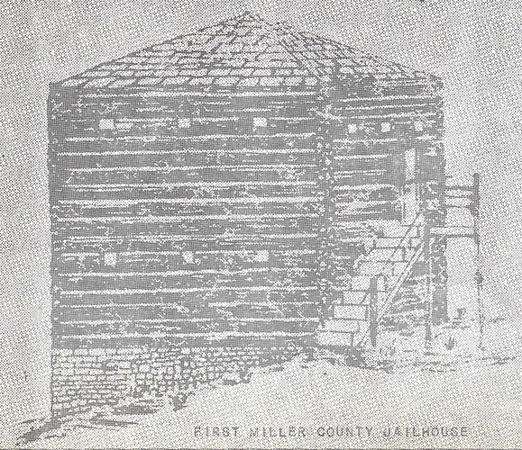
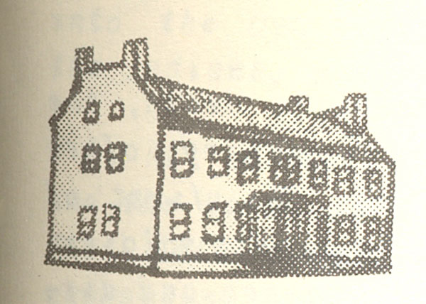
First Miller County Jailhouse
On February 12, 1841, the General Assembly enacted legislation requiring every County Court, at their regular Spring Terms, to ascertain the amount of monies accrued from the sale of the sixteenth sections in school funds; the amount of the road and canal fund; with the interest accrued on each fund; the amount of interest in arrears, and from whom due. Also this act required the County Courts to make out a statement of the amount of the debit due by the County, together with a detailed account of county’ receipts and expenditures for the preceding year, showing the deficiency in the treasury, if any, and the balance, if any.
At the May Term of the County Court in 1841, the first financial statement of Miller County was printed in the record.1
|
Amount that has accrued from Sale of Lands…...... Interest that has accrued on same………………… Interest in arrears for same……………………….. |
$715.95 90.78 43.59 $850.32 |
| Names of persons from whom it is due: Harrison & Bass, $19.58; M.H. Belshe, $5.31 John Bilyeu, $5.00; Larken Osburn, $4.95; John Millhollen, $8.75, Total, $43.59 |
| Amount which John T. Davis received from Birdsong 1840. A former Treasurer Received A.M. Houston, March 16, receipts Received A.M. Houston, May 6, receipts Received A.M. Houston, Nov 5, receipts Received A.M. Houston, Feb 16, 1841 Paid A.M. Houston on warrant Same Same Same Same Paid H.M. Williams on warrant Same Same Same Paid Calvin Gunn on warrant Paid to County Fund to correct error |
$ 69.00 48.50 22.00 156.28 36.93 $332.71 $ 2.80 17.27 3.94 4.98 4.71 6.50 6.50 5.00 3.50 5.00 3.00 Cr. 59.71 $273.00 |
From the above statement it appears that there is at this time the sum of $273 of the County Seat Fund in the Treasury.
| Amount John T. Davis received of Birdsong as Treasurer Received of Wm. N. Harrison on account Received of W.J. McKay on account fine Same Received of Hugh Gartin on account fine Received of James Gentry on account fine Received of William J. Wood on account fine Received of T. W. Whitaker on account fine Received of Whitaker on account revenue Received of Whitaker on account revenue Received of Whitaker on account license Received of Whitaker on account license Paid Grand Jurors on warrants Paid Wm. F. Dixon on warrants Paid John Francis on warrants Paid John T. Davis on warrants Paid R.E. Simpson on warrants Paid John Brockman on warrants Paid Wilson Coates on warrants Paid Wm. Harrison on warrants Paid T.W. Whitaker on warrants Paid George Coker on warrant |
$ 4.00 45.97 1.00 2.00 14.80 2.00 4.16 21.75 55.00 71.47 10.00 11.25 Dr. 243.10 $110.85 140.73 26.00 34.00 11.00 23.00 6.00 56.00 31.60 16.67 Cr. 455.75 (in arrears) 212.65 |
The amount of the Debt due by the County is $910.45
| Total Amount Interest that has accrued to this time Interest in arrears Names of persons from whom it is due: Hugh Challes, $36.24; John Hale, $10.16 Paid Hugh Gartin on warrant B.F. Procter same Andrew Fullen same Wm. P. Dixon same Samuel C. Witten same Ephraim Clark same Josiah Brown same John Davis same Hardin N. Williams same Noah Hudson same R.W. Peckham same Total amount at interest |
$1,341.82 251.63 46.40 $1639.85 5.50 4.00 4.00 3.00 6.00 6.00 4.00 4.00 2.00 2.00 13.75 |
54.25 $1,585.60 |
1. County Court Record Book A, page 110, 111, 112
At this time, 1841, John T. Davis was President of the County Court, John Francis and David Musick, associate justices, William P. Dixon, County Clerk, and Thomas W. Whitaker, Sheriff. The county’ debt of $910.45 was a sum due Judge Davis for having erected the jailhouse, but the county’ debt was considerably more. Several bills were due, and Judge Davis was holding a warrant for $118.20, issued to him for building the Courthouse. The County Fund was behind $212.65; the School Fund in arrears in interest, $43.59, the Road and Canal Fund $46.40.
In 1842, the financial statement listed a county’ debt of: Balance due John T. Davis for building Courthouse, $89.28, interest, $11.82; for building Jailhouse, $637.45, interest, $63.74, making a total of $802.29. Here, it may be noted, the County Seat Fund was dropped from the record, this being money derived from the sale of lots in the town of Tuscumbia.
In 1843, the county’ debt, having increased to $874.95, because of interest due John T. Davis, was on warrants issued to him for having erected the Courthouse and Jailhouse. On November 8, 1843, the County Court ordered the interest due John T. Davis be not allowed. Here, Miller County executed a note in an amount of $726.74 to the State of Missouri, for the use of the Road and Canal Fund, to pay the warrants held by Judge Davis.
In 1844, there was a county’ debt of $763.06. This was the amount of a note payable by the County to the State of Missouri for the use of the Road and Canal Fund of $726.73, and interest on the same up to that time of $36.35.
John T. Davis, from 1838 to 1840, an associate justice of the County Court, was President of the County Court from 1840 to ’43. He was Treasurer in 1840, most of ’41, and all of ’42, ’43, ’44. He was Sheriff and Collector from 1844-46. He erected the Courthouse and Jailhouse. When the buildings were completed, warrants drawn on the County Seat Fund were issued to him for his services. It is almost certain these warrants never were honored. The County Seat Fund was dropped from the record. In fact, trying to obtain his money may have jeopardized his public trust. In the County Court Record on November 11, 1846, the following entry may be found.
Now, at this day, comes John T. Davis, former Collector of the Revenue for the County of Miller, and continued his settlement with the County of Miller, and continued his settlement with the Court; and after a full and complete adjustment of the charges and credits, it appears to the satisfaction of the Court, that said Collector is due the county or the tax book of 1845, the sum of $755.45. After deducting the amount of the Delinquent Tax List for the year 1845, showing that said Collector is due the County of Miller for said tax book and for license mentioned on yesterday, and for taxes collected on the Delinquent Tax Lists of 1840-41-42-43-44 and 45, the sum of $994.56. Which amount said Collector says he is unable to settle.
The next day David Reed, Daniel Boone Etter, William Henderson, and Samuel F. Harrison, four of the securities of John T. Davis, former Collector, asked and obtained leave of the Court to execute a note of $543.24, jointly and severally, for the benefit of the Road and Canal Fund, being their proportional parts said Davis fell behind with the County for Revenue on final settlement as Collector. The note given by the County of Miller to the State of Missouri, for the use of the Road and Canal Fund, was credited with this amount.
On February 2, 1847, Reed, Etter, Henderson, Harrison, and Abraham Castleman, five of the securities of John T. Davis, found their previous settlement in error. The five paid to the county a sum of $710.42, after the previous settlement was rescinded by the Court. This left a balance against Davis of $284.14. In 1851, this balance had been reduced to $46.49, which was the total debt of the county.
Between February and May, 1843, the Courthouse was repaired. Ceiling joists, installed in both rooms were spaced two feet apart. Three-fourth inch planks, well dressed and tongued and grooved were placed on the ceilings. The floors were completely taken up, extra sleepers installed where necessary, and a plank floor of white oak laid and well nailed down. At this same time five good and substantial seats of two inch plank, eleven inches wide and nine feet long, backs well braced, were made. This work was done to order by Hardin M. Williams for $67.45.
During this time the Courthouse was roofed with bur oak shingles, three-fourth inch thick and six inches showing, laid over solid sheeting newly installed. The ends of the Courthouse were weather-boarded with suitable plank, John T. Davis, the undertaker of this project, found his work done very near according to contract with the exceptions of the weather-boarding at the ends. Davis, after agreeing to fix the ends of the building was allowed $50 for his work.
Early in 1847, the Courthouse was repaired again. The doors and windows were cased; shutters made new. A good bolt was put on the side door, with a good lock installed in the front door. A stone chimney, put to one end of the building with a fireplace on the inside, was run two and a half feet above the roof. A new twelve light window with good shutter was placed on the side of the building near the chimney. Cracks in the building, having opened everywhere were filled with sand
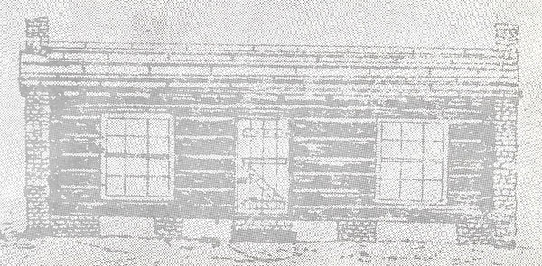
First Miller County Courthouse
As remodeled in 1847
and lime. The foundation, underpinned with rocks, was made tight. Doors and windows were faced with dressed seasoned walnut. The front platform was fixed to drain water from the wall instead of toward it. For building the chimney, William C. Short was allowed $43. For repairing doors and windows, John T. Davis was allowed $10.
In 1850 the Jailhouse was repaired. Three-eighth inch iron bars were placed over the outside door.
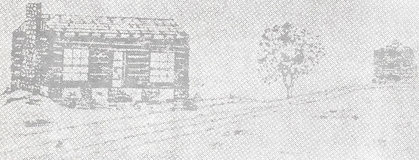
Tuscumbia street scene, showing first Courthouse and Jailhouse
On February 7, 1844, Daniel Cummings was allowed seventeen dollars from the Road and Canal Fund for procuring a Seal for the use of the County Court. It was of the following description: A dotted circular line around the outer edge of the face. Within the outer circular line a raised circular line on the face. Within the two circular lines above described, the words, COUNTY COURT MILLER COUNTY MO. Within the inner circular line a device of a hogshead of tobacco.1
This Seal has certified the official proceedings of the County Court ever since, more than 126 years.

Seal of the County Court
1. County Court Record Book A, page 179
On April 9, 1844, the Judge of the Circuit Court ordered a Seal of the following description, viz: A dotted circular line around the outer edge of the face; and within the outer circular line a raised circular line on the face; and within the two circular lines above described the words CIRCUIT COURT OF MILLER COUNTY MO and within the inner circular line a devise of a BERKSHIRE BOAR be adopted as the Seal of this Court.1
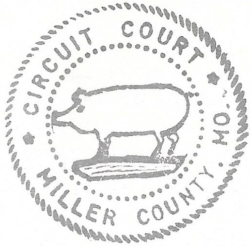
Seal of the Circuit Court
1. Circuit Court Record Book A, page 127
On August 3, 1847, the first Public Administrator1 in Miller County, Daniel Cummings, was appointed by the County Court. Cummings having served as Treasurer in 1844, resigned from the office on February 6, 1845, then served as Deputy Clerk of the County Court until August 2, 1847. Again, appointed Treasurer, he served six years.
Hugh Challes was appointed Public Administrator in 1849.
1. Circuit Court Record Book A, page 330
The Osage river was the most important highway of trade and travel through the territory of Miller county prior to the late 1880’s.
Clement D. Treget built a house by the Osage river in what is now Bates or Vernon counties in 1787. In the 1790’s, August and Pierre Chouteau formed Fort Carondelet around this dwelling. This was the second Fort established in outstate Missouri, Fort Orleans being the first.
August Chouteau, a very successful Indian Trader, made a fortune in furs and peltries. His fur trade was the most important factor in opening the territory along the Osage river to the eyes of the restless frontiersmen in Kentucky and Tennessee.
For some time Chouteau possessed the sole and exclusive right to all Indian trade along the Osage river. This monopoly was granted to him by the Spanish Government in the early 1790’s. Around 1802, Manuel Lisa, an old Spanish sea Captain, was granted this sole and exclusive right to trade with the Osage Indians. When the present area of Missouri was transferred to the United States by purchase from France in 1804, this Indian trade from the Osage valley amounted to thousands of dollars annually.
Government factories, or trading centers, were established on the Missouri river by the Federal Government, to help the Indians get a better deal on produce and peltries, but when licensed by the Superintendent of Indian Affairs at St. Louis, an individual could still hunt or trade with the Indians on private initiative.
Mathurin, Gouveville, Treget, Dion, Beavois, Bill Williams, Daniel Boone, the Chouteaus, and others hunted along the Osage river.
Explorers, like Zebulon M. Pike, following the Osage river to the Kansas’ prairies, and on to the Far West, while traversing the Osage valley, including Miller county, reported on the fertility of the soil, the kind and extent of the timber, the animal life, and the sources and nature of the river’s many tributaries.
The furs and peltries of the earliest hunters, trappers, and settlers, were sent to market in almost every conceivable kind of craft. Canoes, rafts, barges, flat and keelboats were filled and floated down the river. The Osage, a stream of shallows, hairpin turns, sandbars, and tricky currents, eventually found the flat and keelboat the chief means for bringing merchandise in, and taking produce out. These boats were especially designed for use on the Osage river, drawing only a few inches of water, and built very sturdy. The flat and keelboat continued well into the steamboat era.
Most of the keelboats on the Osage were something like 100 feet in length. Usually, a bow pole, some 20 to 30 feet in height, adorned the front of these boats. Attached atop this pole was a long tow-rope. When carried ashore this rope was used for pulling the keelboat over deep water. This was done by men sweating, wading, and walking along the rough river bank. The high pole tended to keep the rope from entanglement in the rank undergrowth of the wilderness along each side of the river.
Six or eight men usually propelled these boats over the shoals. Every man aboard carried a long pole. These Poles were thrust upon the bottom of the river and held there. The men then walked from the bow to the stern. Upon reaching the stern of the boat each man returned to the bow. With an even number of men on either side of the boat, the craft was propelled by pole-ing through the shallowest of waters.
Often from six to a dozen of these boats were tied-up at the mouth of a slough, now known as the Shut-In branch, which first was near an Indian Trading Post by a big spring, later J.P. Harrison and brother’s storehouse, then, following, 1837, at the Tuscumbia' Landing.
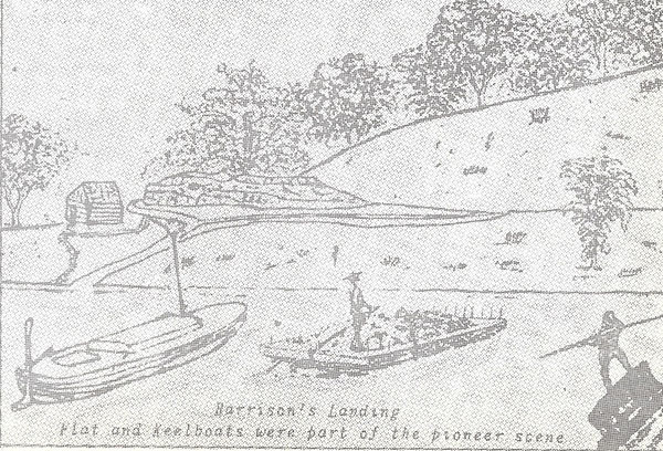
Harrison's Landing
Flat and Keelboats were part of the pioneer scene
The development of the county was hardly begun until there was a real yearning for improved roads. Early travel was on foot, by oxen, by horseback, or by crude carts and covered wagon.
The first trail across Miller county, after the Indians, was the old Harmony Mission Trace. When Miller county was organized the remains of this Trace crossed the western boundary of the county near Edmund Wilkes and Alfred M. Houston.
Edmund Wilkes, one of the first Justices of the Miller County Court, and Alfred M. Houston, the first Commissioner of the Miller County Seat of Justice, lived South and North, respectively, from where State Highway No. 52 now leaves Miller county toward Barnett.
Before Miller county was organized, Hiram Russell and Hardin Nolen were overseers of roads first in Clark township, and after September, 1835, in Saline township, Cole county. The place of meeting in Saline township was at William Brockman’s house; with Alfred M. Houston a Justice of the Peace. When Miller county was established in 1837, Saline township retained its name.
On July 11, 1837, Squire Hiram B. Russell was appointed by the Miller County Court to lay out the township of Saline into convenient road districts. On August 8, Squire Russell submitted to the County Court his report on road districts, the numbers thereof, and overseers, as follows:
Road District No. 1. Beginning where the township line of Saline crosses the road leading from Tuscumbia to Boonville thence to the county line dividing the counties of Morgan and Miller. Andrew McCastan, overseer.
Road District No. 2. Commencing at the forks of the road between Edmund Wilkes and Alfred M. Houston, thence toward Jefferson City as far as the fork road near Joseph D. Taylor’s shop. Oliver O’neal overseer.
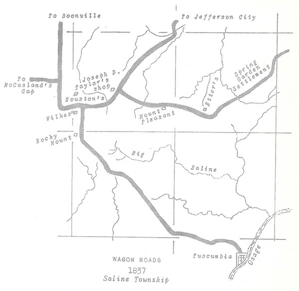
Wagon Roads 1837
Saline Township
Road District No. 3. Commencing at the fork road near Joseph D. Taylor’s shop, thence on the Spring Garden road as far as Samuel Etter’s. Mellos Moore, overseer.
Road District No. 4. Commencing at the fork road near Joseph D. Taylor’s shop, thence towards Jefferson City to the county line dividing the counties of Miller and Cole near the South Moreau. Samuel Gilleland, overseer.
Road District No. 5. Commencing at Samuel Etter’s thence down the Spring Garden road to the county line between the counties of Miller and Cole. Robert E. Simpson, overseer.1
Andrew McCasten, actually Andrew McCastland, listed as overseer of Road District No. 1, owned land west and northwest of what is now West Aurora. On November 7, 1837, Andrew McCastland presented to the County Court an order of Edmund Wilkes, one of the Justices of said Court, for a review of the road leading from Tuscumbia to the county line in the direction of Boonville. The County Court appointed John Lumpkin, Uriah S. Dooley, and Alfred M. Houston as commissioners to have this proposed change reviewed. Since the road passed over ground McCastland was desirous of cultivating, the commissioners recommended the road re-routed, and the County Court approved the new way.
Generally, from Tuscumbia, the Boonville road followed what is now State Highway No. 52 to the U.S. 54 junction, then proceeded to where West Aurora is now located. From West Aurora it led in a northwestwardly direction by way of early Rocky Mount. Then the road entered into Morgan county where it turned due north and followed the Miller-Morgan boundary line on the west a half-mile or less into Moniteau county, and on to Boonville. This Boonville road was earlier the road from Franklin to the Osage river.
Road Districts No. 3 & 5 were parts of the old Harmony Mission Trace to the mouth of the Osage river, and later, No.’s 2 and 4 were parts of the same trace from Jefferson City. Travelers from Jefferson City to Tuscumbia first came by way of Rocky Mount. They followed the old Trace to the Boonville road, then passed through Rocky Mount to Tuscumbia. At this time Rocky Mount was located in Section 6, of Township 41N, Range 15W.
Alfred M. Houston traveled the road from Rocky Mount to Tuscumbia when he was Commissioner of the Miller County Seat of Justice. In the beginning he traveled by ox-wagon, which required 18 hours of traveling time before arriving at Tuscumbia. Later, with a good team of horses, Tuscumbia could be reached before noon.
1. County Court Record Book A, pages 13 & 14
On August 8, 1837, Edward Carter presented to the County Court a petition from inhabitants of Equality township praying for a public highway leading from the ferry landing opposite Tuscumbia to the county line in the direction of Smather’s Mill in Pulaski county. Isaac Bass, Thomas Davidson, and James Armstrong were appointed commissioners by the Court to view and mark out the road. On May 7, 1838, the commissioners submitted the following report: Commencing at the ferry landing opposite Tuscumbia, thence across the bottom by way of the bridge to the foot of the hill; thence in a southwardly direction passing to the right of Judge Francis by Hudson. Running through John Davidson’s field; thence up Dog creek as near as may be in the same direction to the head of said creek, passing about three hundred yards to the right of C.P. Davidsons to a hollow running into what is denominated Mill creek. Thence down said hollow to the road leading from the Richwoods to Judge Fulbrights. Intersecting said road at the crossing of said creek below Carmikles. Thence following said road to a stake about three hundred yards north of Thomas Pembertons; thence following in a southwardly direction through Pemberton’s field and intersecting the aforesaid road again, and following the said road with very small variation to the lower end of John Deen’s field. Thence trough said field on a direct line to where the above mentioned road crosses the creek that runs by said field, probably known by the name of Deen’s creek, and believing that to be about the line dividing Miller and Pulaski counties we declined looking further.1
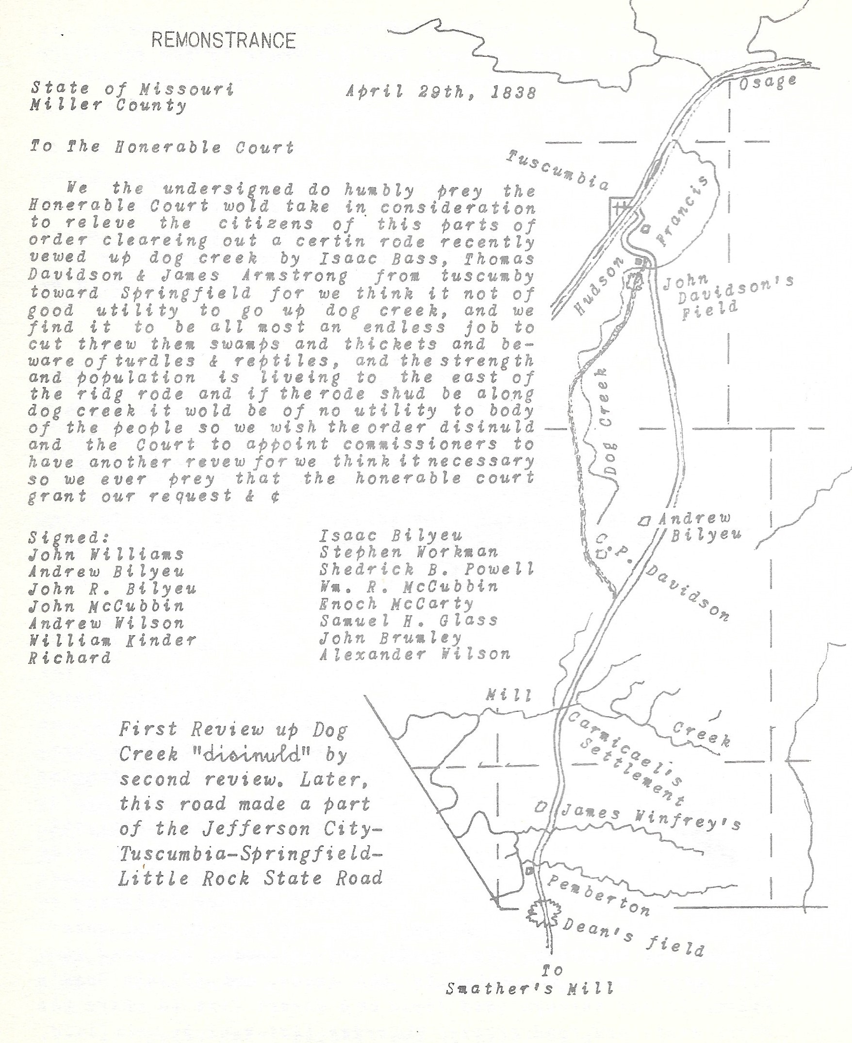
Remonstrance
Click image for larger view
Immediately, John W. Williams presented a remonstrance to the county Court against the opening of this road. A sufficient number of signatures to the remonstrance lawfully forced the route’s review. Alexander Wilson, Jacob Davis, and Mastin Skaggs appointed by the Court, commissioners to review the route, refused to act, so Benjamin Wiseman, John Brockman, and William King were appointed in their steads. On December 17, 1838, they reported: Beginning at the ferry landing opposite Tuscumbia, thence along the old road across the bottom to the hill. Then up along the foot of the hill to John Francis, then turning to the left round the point with the old road up to the head of the little branch across the hill at or near where Noah Hudson is now building on the main Dog creek. Thence to the right across the bottom and up the hill where John Francis dug the road. Thence nearly with said road to Andrew Bilyeu; thence near a mile with said road. Leaving and taking to the left along a barren ridge to the head of a hollow then down said hollow to the place where Carmicael settled. Thence with the old road to Mill creek and up a barren hollow near the head. Thence turning to the right from the old road along a dividing ridge, then down a hollow near James Winfrey’s. From there across the main Glaze to the county line.2
1. County Court Record Book A, page 31
2. Ibid., page 47
On February 5, 1838, Johathan Blevans presented to the County Court a petition of sundry inhabitants praying for a road leading from the ferry landing opposite Tuscumbia to the county line in the direction of Little Piney in Pulaski county. Josiah Stuart, John Hale, and John B. Harrison were appointed commissioners to view and mark out the road.
On May 8, 1838, the commissioners reported: Commencing at the ferry landing opposite Tuscumbia, then across the bottom by the way of the bridge to the foot of the hill. Thence up the bottom passing to the left of Judge Francis and crossing the ridge to Dog creek. Then crossing said creek and up a branch in a south east direction known by the name of Cattail fork to near its head. Then taking a ridge bearing near the direction towards Judge Blevans in the Big Richwoods, crossing the Barren Fork of the Tavern near James Brumley’s. Passing Judge Blevans in the Big Richwoods. Thence to W. Joneses on the Big Tavern. Up said creek, passing to the left of Shelton Davis and Isaac Bilyeu. Thence to Josiah Sims where the county line is said to be; and we supposed the distance to be near twenty-one miles and its general course southeast. Road opened to be 20 feet wide, with John Stewart and James Brumley, overseers, in Richwoods; John Brumley, overseer, in Equality.1
Tuscumbia - Little Piney Road 1838
1. County Court Record Book A, page 33
On November 7, 1837, W.N. Harrison presented to the County Court a petition for a public road leading from Tuscumbia to the county line where the Jefferson Road crosses the same near Richard W. Taylor’s. William Bennett, Wyatt Stubblefield, and Andrew McCasland were appointed commissioners by the Court to view and mark out this road. They reported in the following manner: Commencing at Tuscumbia and following the Boonville road about one mile to the fork road leading to Thomas Sarter’s Mill with very little variation to said mill; thence taking the road leading from said mill to Andrew Burriss, and following said road about two hundred yards beyond the race tracts. Thence about a north course through the prairie edging the Points of timber putting up to the prairie to a path leading from Hales old improvement to James Mason’s. Thence with said path by way of Masons to where said path intersects the Jefferson Road at Gregory’s old improvement near the South Fork of Moreau creek. Then with said road to the county line as above named.1
This report, publicly read by the County Court, and no objections being heard to it, with the Court having an opinion the road would be of public utility, ordered the view opened twenty feet wide agreeable to the statutes in such cases, and further ordered William Miller and Thomas Sarter, overseers of the road in Saline township, J.P. Harrison, overseer, in Equality township. This view, immediately opened, was afterward known as the Tuscumbia-Boonsborough2 road.
Thomas Sarter’s mill was by the Saline creek, located where Judge Paul Martin now lives. Andrew Burriss, a storekeeper, was at Pleasant Mount. Richard Taylor lived near the Moreau creek, northeast of present day Olean.
1. County Court Record Book A, page 29
2. Boonsborough afterward named California
Tuscumbia - California Road 1837
On May 7, 1838, Abraham Castleman presented the County Court a view of a road laid out and marked by himself, John Brockman, and Boyd Miller, leading from Tuscumbia to easterly of Spring Garden, in the following manner: Commencing at Tuscumbia, thence in a northeastwardly direction down the Osage bottom, keeping near the hill to where McCarty family lived. Thence bearing something more north and across the ridge, leaving Stephen Loveall’s house about two hundred yards to the left, and continuing as near as may be the same direction to the Saline creek, and crossed the same at Brockman’s Sawmill, and took a ridge to Lick creek, and crossed said creek about one mile from its mouth, and continued about the same direction crossing some of the tributary streams of the Saline creek. Leaving Madison H. Belshe’s house about one hundred yards to the left hand; thence to the aforesaid line dividing Miller and Cole counties, at Section numbered Nineteen in Township numbered 42 and Range numbered Thirteen as aforesaid.1
The County Court appointed Abraham Castleman, overseer, in Equality township; Stephen Loveall and Madison H. Belshe, overseers, in Jim Henry township.
Tuscumbia - Spring Garden Road 1838
Brockman's Sawmill located at Sulpher Spring on Big Saline Creek
1. County Court Record Book A, page 30
On May 4, 1840, Hardin M. Williams, William A. Shelton, and Joseph Martin, commissioners of a county road leading from the ferry landing at John Brockman’s on the south side of the Osage river toward Harrison Davis in Pulaski county, reported to the County Court in the following manner: Beginning at the ferry landing and leading in said direction around the point of the ridge to Bear creek, marking with a tomahawk. Thence taking the meandering of the bottom of said creek above the settlement. Thence leading up a ridge to the south, following the meandering of said ridge to where it intersects the road leading from Este’s old ferry. Thence with said road having due regard to ground and crooks to the fork road, the left hand leading to Johnson’s Mill, the right to Mr. Dodsons on the Glaze. And having been informed this was at or near the county line we then terminated the view by twelve hacks on each side of a post oak tree west of said road, all of which road is marked by hacks with a tomahawk.1
Brockman Ferry - Glaze Creek Road 1840
1. County Court Record Book A, page 84
On November 3, 1840, John Brockman presented to the County Court a petition signed by sundry citizens of Equality township asking the newly cut road from Brockman’s ferry on the Osage river (leading toward Harrison Davis) be extended northward to the road leading from Tuscumbia by Edmund Wilkes toward Boonville. Gabriel Cotton, John Davidson, and Jonathan Loveall, appointed commissioners, viewed a route which was approved by the County Court; and opened by cutting-out, the following year.1
1. County Court Record Book A, page 96
Probably the first road in the later territory of Missouri was established by Renault, a Frenchman, in 1725. Having erected a lead smelting furnace at mine LaMotte, to move heavy lead ingots overland to the river, he opened a way to the Mississippi; known as the Three Notch Road.
In 1770, the Spanish Commandant opened a Trace leading from St. Louis to New Madrid, which followed the old Indian Trail generally traveled first by De Soto 200 years earlier.
The Territorial road law first adopted was in 1806, but the first Territorial road, running from St. Louis to the Ste. Genevieve then on to Cape Girardeau and New Madrid, established by an Act of the territorial legislature, was approved by Governor Meriweather Lewis on June 30, 1808. Generally, this road followed the old Spanish Trace, called LaRue Royale by Frenchmen, and El Camino Real by the Spanish inhabitants, meaning King’s Highway.
In 1827, the Boonslick Trace was made a State Road, and in 1835, a State Road was established from St. Louis to Jefferson City. A State Road following the old Osage or Kickapoo Indian trail from St. Louis to Springfield was approved by the Governor on February 6, 1837, the same day he approved an Act which established Miller county.
Although created by Acts of the General Assembly these State Roads made little improvement in over-land transportation for local inhabitants, in each neighborhood along the routes, maintained them.
The first State Road across Miller, after the county was organized, was established in 1839 by a Report of Commissioners appointed under an Act approved January 25, 1839, to view and mark out a State Road from Jefferson City, Cole county, to Tuscumbia, Miller county, and then to the state boundary in a direction of Little Rock, Arkansas.
This is to certify, the report continued, after being duly sworn, that we, the undersigned commissioners, Ephraim Clark, Samuel C.H. Witten, and Hugh Gartin, on the refusal of the other commissioners mentioned in said act to serve, met pursuant to previous notice at the City of Jefferson on the 27th day of May, 1839, for the purpose of viewing and marking out a State Road from Jefferson City to Tuscumbia, and proceeded to organize by appointing Ephraim Clark, Chairman of the Board; Robert W. Peckham, Surveyor; Andrew Fullen and Josiah Brown, Chairman; Benjamin F. Proctor, Hiram Messersmith, and John Davis, Assistants.
We then commenced the road at the point where the center of Jefferson Street joins the town boundary of Jefferson City lands and running the courses and distances noted down in the map and field notes hereby witnessed.
We followed the general course of the State Road heretofore located from Jefferson City to Versailles, Morgan county, for the distance of 2 miles, 200 rods, and 20 links, where we left said road. We then proceeded over vacant lands by the courses and distances mentioned in the map which accompanies this report, to the Moreau creek, and across said creek at a point where the North bank is solid rock about 15 feet high. We estimated the expense of a bridge at this crossing to cost fifteen hundred dollars. Thence through the Moreau bottom, and up on the dividing ridge between the waters of Honey creek and the South Fork of the Moreau creek to a road known as the Kingery road. Thence over vacant lands to a county road from Jefferson City to Spring Garden, Miller County.
Thence following said county road to the SENE of S 35, T43, R13, to the county line between Cole and Miller counties and then through the NWNE of S24, T42, R14, the right of way being relinquished by Madison H. Belshe. Thence through the W ½ of SE Qtr S24, T42, R14, the right of way being relinquished by Samuel C.H. Witten.
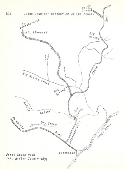
First State Road into Miller County - 1839
Thence over vacant lands to the county road from California, Cole county, to Tuscumbia, and following the general course of said road to the Town of Tuscumbia, which is 32 miles, 239 rods, and 5 links from Jefferson City. Completed June 8th, 1839.
We, the undersigned Commissioners, do certify that we believe the proposed route cannot be improved in distance or ground, since it passed over high-dry ground, a great portion of which is thinly timbered, barren, with some prairie. Ephraim Clark, Sam C. Witten, Hugh Gartin.
On November 5, 1839, Ephraim Clark and Samuel Witten were allowed $6 each, by the County Court, Hugh Gartin, $5.50, for services while commissioners on this State Road. John Davis and Josiah Brown, Chain carriers, were allowed $4 each; Andrew Fullen and B.F. Proctor, assistants in the survey, $4 each. The Surveyor, R. W. Peckham, was allowed $13.75 for his services. These payments were made from the Road and Canal Fund.1
1. County Court Record Book A, page 71. Ninety years later U.S. Highway 54 generally followed this survey of the first State Road from Jefferson City toward the Miller County’ line east and south of Spring Garden.
In 1841, the above road was surveyed from Tuscumbia to Springfield. A report on this part of the State Road follows:
A report of the commissioners appointed by an Act of the General Assembly of the State of Missouri, approved February 15, 1841. In pursuance of said Act, William Miller and Andrew Burriss, two of the commissioners therein mentioned, met at Tuscumbia on the 1st Monday in May. The other commissioner, Thomas Martin failed to attend. The two in attendance then adjourned to meet on the 17th of the month; Thomas Martin being notified by William Miller of the day of the meeting.
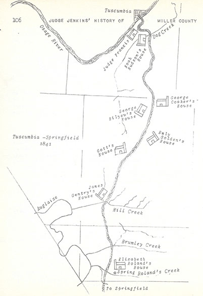
Tuscumbia - Springfield 1841
In pursuance of adjournment, William Miller and Andrew Burriss met in the town of Tuscumbia, but Thomas Martin still failed to attend. We then proceeded by appointing Andrew D. Mehaffey in his stead, he being from the same county and township, and organized by appointing Andrew Burriss, Chairman, and after being sworn according to the law, we appointed John Brockman, Surveyor; William R. McCubbin and Samuel C.B. Witten, Chainmen; Hardin Williams, Fore Vainman; William Greenup as Marker; Henry Dunehue, Camp Keeper and cook.
We then proceeded to the South Bank of the Osage river at the ferry landing. The Course and Distance being required of the Surveyor, the course was reported to be South 34 deg 05 min West, distance 82 miles.
We then commenced at the ferry landing at which point we set a stake from which a black walnut 23 inches in diameter bears South 52 West 51 links distant, which we marked with a blaze and a notch, and on the blaze we marked in a plain and distinct manner with a marking iron, the letters (S R);1 the land on which we commenced being owned by John Frances.
We run through the said land to the end of the first mile, at which point a blackoak 12 inches in diameter was marked with the letters (T 1 M).2 We deem this sufficient to show the manner in which the road has been marked out. In looking over the plot of this road, it may appear strange to those that are unacquainted with the Geography of the Osage and Niangua country to see how far we have departed from the true course. To those who are acquainted with this country, the cause is obvious. The Osage, Glaize, and Niangua hills intervening compelled us to make those east bearings in order to get ground suitable, and by doing so, we have got an extraordinary route.3
From the end of the first mile we fun across a high ridge to Dog creek, the land owned by Noah Hudson. Thence through poor barrens to the Little Richwood which is a settlement of fertile land; through the lands of William Bilyeu, John R. Bilyeu, Simon T. Bilyeu, Emly Golden, John R. Bilyeu, Lydia Bilyeu, a non-resident, to Jess Gott’s, to James Gentry. Then over poor land to the Deans Fork of the Glaize. Up said creek the land is good, though not in market. To the Wet Glaize, the land good on this creek.
From here the road went to the prairie at McFail’s land; over poor land to Mehaffey’s Prairie which is good land and thickly settled; to the Niangua with good bottom land; to Greene county line and poor land, on to the Public Square in the Town of Springfield, on the 11th day of June, 1841.
1. Meaning South of River
2. Meaning Tuscumbia one mile
3. Report of Surveyor Brockman
An Act of the General Assembly of Missouri, approved December 19, 1841, established a State Road from Tuscumbia to Forsythe. George W. Robinson, Amos N. Commas, and Hugh Snelling were commissioners; John Brockman, Surveyor; Joel Thacker and Hardin M. Williams, Chain Carriers; John Snelling, axeman,. They left Tuscumbia on June 24, 1841, running by the residences of John Francis, Noah Hudson, George Coaker, George Bilyeu, Emly Golden and crossing Mill creek, to Daniel Williams. They entered Kinderhook county near John Dean’s house. Then to Samuel Meridah’s, by John Este’s house, to Smith’s Mill in Kinderhook county; and on to Forsythe.
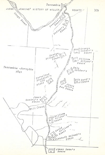
Tuscumbia - Forsythe 1841
This road established in pursuance of an Act entitled an Act to establish a State Road from Jake’s Prairie in Gasconade county to Iberia in Miller county,1 approved February 27, 1843.
John Wilson and Gilbert Crismon, two of the Commissioners therein named met at Jake’s Prairie on the 18th day of July, 1843, as provided by agreement. James Wilson and John Miller, the other two commissioners, failed to appear.
When the Commissioners in attendance appointed William Northrup in James Wilson’s stead, he being from the same county and township in which said Wilson resided, and James Boyer in John Miller’s stead, being from the same county and township in which said Miller resided; the board was organized by appointing John Brockman, Surveyor; Edward Henderson and James Hooper, Chain Carriers. Anthony Hinkle, Marker; and Thomas Lockheart, Flag bearer, all of whom were sworn according to law.2
Beginning where the roads leading from Hermann to Massey’s Iron Works, and from St. Louis to Little Piney crossed, they proceeded until the road entered Miller county near A. Roudens, then to John Bilyeu and across the Tavern by William Bilyeu’s Mill. To Mordica Lane’s, Louis Dyer’s, William Dyer’s, arriving at Iberia on the first day of August, 1843.
Here, Anthony Hinkle and Thomas Lockheart resigned, with John Bilyeu appointed and sworn in Hinkle’s stead as marker; Peter Bilyeu appointed and sworn in Thomas Lockheart’s stead as Flag Bearer.
The crew then continued marking the road to the land of Creed T. Biggers; across the Barren Fork by S.B. Powell’s, to the land of James Gentry; crossing the Wet Glaize to a dividing ridge; onward to the middle of the main street leading to the Public Square in the Town of Erie, Camden county, formerly Oregon and Kinderhook county, on the 28th day of November, 1843.
A point of interest along this road was William Bilyeu’s mill on the Big Tavern creek. S.P. Record’s house was shown at Iberia, as was William Short’s, W. Burk’s, and M. Lane’s nearby. J. Gentry’s house was located where the Jefferson City – Tuscumbia – Springfield State Road forded Mill creek, near present day Brumley. From Iberia to Mill creek only two houses may be found along the road, -Creed T. Biggers on the eastern side of the Barren Fork by a spring, and S.B. Powell’s house on the western side of the same creek by a spring. Thomas Sarter’s mill, south of the Wet Glaize, was located opposite the mouth of Mill creek. Sarter having moved here from the Big Saline creek.
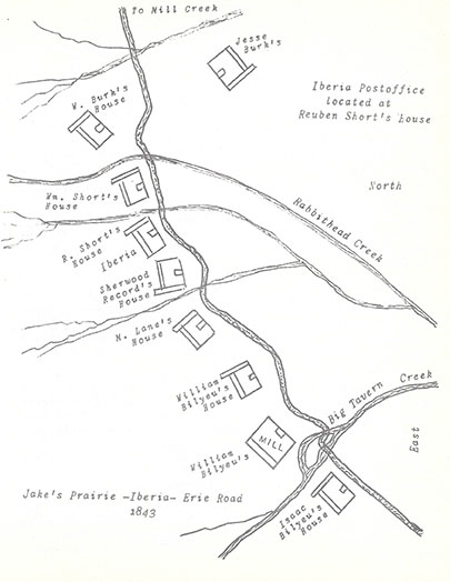
Jake's Praire - Iberia - Erie Road 1843
1. Afterward, Camden county
2. Surveyor Brockman’s report
In 1847 a State Road was surveyed from the Osage river opposite Lisletown in Cole county to near the residence of Judge Zacheas German on the road leading from Tuscumbia in Miller to Versailles in Morgan county.
In pursuance of an act to establish a State Road, approved February 15, 1847, none of the Commissioners met a James Williams’ on the set day, but by provision of said Act, Hiram M. Smyth, one of the Commissioners, attended in the Town of Mt. Pleasant on the 17th day of April, 1847. Zacheas German and William Miller, the other two Commissioners, failed to appear.
Agreeable to a letter H. M. Smyth received from Zachaes German they then planned to meet on the 17th of May. Again Smyth received a letter from Judge German stating they would meet in the Town of Mt. Pleasant in Miller county on the 29th of May.
When convened according to appointment, William Miller resigned for want of a commission, then Smyth adjourned to meet on the 7th of June at his house. Zachaes German failed to attend this meeting, and on the 19th of June, he resigned. H.M. Smyth then appointed the 19th of July to meet at his house for the purpose of organizing.
Meeting pursuant to adjournment, Commissioners appointed in the places of Judge German and William Miller were Boyd Miller and John Bond. Upon organizing, Boyd Miller was chosen Chairman, John Brockman, Surveyor; Joseph Hogg and Henry Purvis, Chainmen; James Purvis, Assistant, and upon being duly sworn by James Moore, Esqr., of Cole county, on the 20th of July, 1847, proceeded to the North or left bank of the Osage river opposite Lisletown at the ferry landing in the State Road leading from St. Louis to Jefferson City.
John Brockman, Surveyor, reported: With my compass adjusted to the variation of 7 ½ deg E, I proceeded from which point a sycamore 36” in diameter bears N 60 ½ E 83 links distance. Marked N R in a plain manner for North Side of river.
From thence, Brockman continued, we run N 59 deg W 54 chains along said State road on Lisle’s land; assessed no damages. We then proceeded by James Williams’ house and over his land. This shows we run another plat for particulars, with only the bearings given which are on this sheet, that is, the part in Miller county.
Surveyor Brockman’s field notes revealed while approaching the eastern edge of Miller county, but still in Cole, they passed over Martha Farmer’s land; into Miller county over John Bond’s and Boy Miller’s land. Here the road entered into the Spring Garden settlement, passing over land belonging to Thomas Sullens, Robert E. Simpson, Samuel Cecil Holiday Witten, Robert and Franklin Belshe, Mortimore McKenny, William Bond, to the land of Rosannah Etter.
Thence the road passed over lands belonging to Samuel Allen, Hiram B. Russell; following the boundary line between William Miller and Bliss. Thence across the lands of Samuel Jones, John Balance, Mellon Moore, George Shepley, William G. Burks, Joseph D. Taylor, William Clark, Bailey Taylor, Willis Jolly, and A.M. Houston, to the road from Tuscumbia to Versailles at or near Judge German’s residence, near the center of Section 23, Township 42, Range 16, in Morgan county. The plat of this State Road was filed for record on August 4, 1847.
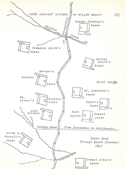
State Road through Mount Pleasant 1847
In 1841, a State Road was surveyed leading from Russelville, in Cole county, to Springfield, in Greene county, which crossed the Osage river at the old Miningport Ford. This road soon destroyed the route of the Old Harmony Mission Trace across the northwestern corner of the county.
Stages were running over the northern portion of this State Road by the later 1840’s from Jefferson City to Versailles. Winston & McKenzie used this route for freight wagons to the Far West. A petition presented to the Miller County Court to change a portion of this road, drew a remonstrance, signed by more than one hundred citizens of Miller county, stating this road is known by emigrants from Indiana and Ohio to Oregon and California.
This road gave rise to the first Wayside Inn in Miller county. It was located in Section 17, Township 42, Range 15, operated by Willis Jolly, later by James Hite. There were sleeping rooms, a large dining room, and a huge log stable nearby, affording travelers many comforts and conveniences for themselves, oxen, and horses.
It was near this place that a wagon train, returning from the California gold fields, with much diggings aboard, was attacked by a band of outlaws outfitted as Indians. A gentleman who escaped was reported to have hidden most of the gold in the hollow of a large tree near the Inn.
The Walker Inn, one-half mile South of the Moreau creek, was a prominent stopping place on this same State Road, later.
Two pioneer roads of importance in Miller county extended from Jefferson City into the Big Richwoods. One trail crossed the Osage river on the Witten’ Ferry, at Fair Play, in Jim Henry township; the other at Davis’es (later Clark’s) Ferry, in Cole county. The latter trail was made a State Road in 1857. In 1860, a State Road was surveyed and established from Iberia1 to Hickory Hill, fording the Osage river near the Capps’ settlement, and mills, at the mouth of Humphrey creek.2
A Road in the western part of Miller county, running North and South, was laid out in the 1850’s, leading from the high point at Latham’s storehouse and postoffice, in Moniteau county, commencing at or near Allen’s still-house on the county line between Moniteau and Miller counties, and thence running a nearly south course, crossing the Osage river immediately below the mouth of the Little Gravoix, intersecting the Tuscumbia-Erie road at or near the head of the Elm branch
Richard Compton, Jonathan Loveall, and Berry Taylor, appointed by the County Court, Commissioners to view and mark out this road, met at Andrew McCastlands on the third Saturday in July, but failing to act, the Court appointed William M. Brockman, John B. Thurman, and Joseph L. Cotton to serve in their stead.3
On August 5, 1852, the Commissioners reported: We met at Reuben Burnett’s on the 24th day of October, 1851, and after being duly qualified according to law proceeded to view and mark out said road as follows: Commencing in the Tuscumbia and Erie road at Roberts branch near the Ellm branch, and thence taking a dividing ridge to Starling Conner’s farm and through his land, the right of way being granted, crossing the Osage river below the mouth of Little Gravoix, thence up the Gravoix’ bottom to Thomas McCombs, the right of way being given.
Thence up said bottom to Thomas Cotton, the right of way being granted, and thence taking a dividing ridge and intersecting the Boonville and Tuscumbia road at N.W. Corner of Sect. 16, T. 41, thence along said road to the corner of Andrew McCastland’s field, thence to Wilson Alley’s right of way granted, thence north through the lands of Gabriel Cotton, right of way granted. Thence north to or near Albert G. Wilkes, said Wilkes refusing to grant the right of way, thence taking divide of ridge to William Clark’s field, thence to the east corner of William P. Dixon’s field. Thence on a dividing ridge north to Joseph D. Taylor’s farm and ending at the creek near Allen’s still house.4 The County Court ordered the road opened 20 feet wide.
Much can be learned from the surveys and views of these earlier roads in Miller county. References are given to various shops, businesses, homes, settlements, grist and saw mills, ferries, race tracts, township lines, and other places of interest. Unique road descriptions may be found, like: Ordered that J. Mathews have leave to open a road through the 16th Section in Township No. 41 of Range 14 so as to enable the said Mathews to haul tan bark through the same.5
Blazing through the barrens and woods from thence through the prairie; -marking with a tomahawk; -thence with the old road up barr creek;-beginning at a buffalo lick; -commencing at or near Thomas Allen’s corn crib, and running northwest, intersecting the old road at Anderson Allen’s tobacco barn; are some of the words and phrases describing earlier paths, trails or roads.
The Old Harmony Mission Trace, Blue-Tail Trail, and Miningport-Waynesville road, -the main immigrant’ routes in the 1820’s and earlier 30’s, -were abandoned and generally forgotten by 1860, with a pattern, or system, of roads developed which exist yet today.
On these pioneer trails through the wilderness, farm produce in the county found an outlet, by slow and tedious haulage across the hills and hollows, to the Osage river. In fact until the coming of the railroad in the early 1880’s, the inhabitants of Miller could not have profited in surplus grain and livestock had it not been for a navigable river flowing through the county.
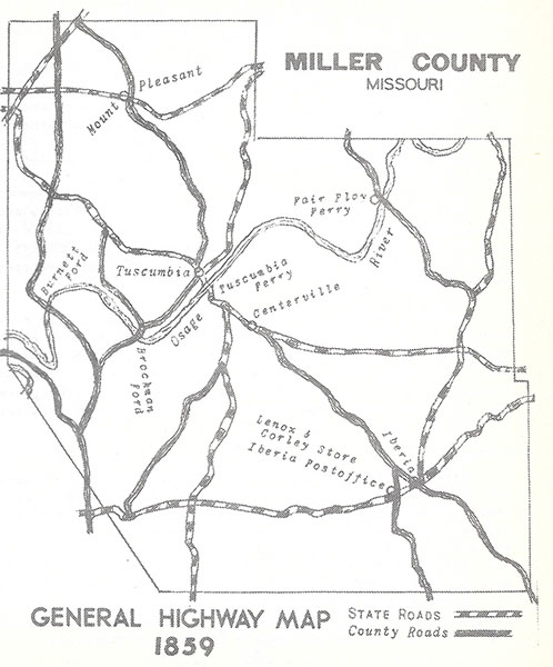
1. To Iberia Postoffice at Wilson Lenox’s storehouse
2. John L. West, C.A. McCarty, and Ed Riggs were the Commissioners; Madison H. Belshe, Surveyor. The total cost for having this State Road surveyed from Hickory Hill to Iberia postoffice was $58.
3. County Court Record Book A, page 538
4. County Court Record Book B, page 60
5. County Court Record Book A, page 131
The first ferry in the present territory of Miller county was situated on the Osage river above present day Bagnell Dam. Andrew Estes was the proprietor. The second ferry was at the Brockman Ford, John M. Brockman proprietor. The third ferry was at the western ending of the old Blue Tail trail, T.O. & T. G. Witten, proprietors. The fourth ferry was at Harrison’s Landing, J.P. Harrison & bro., proprietors. They were removed the following year for Cornelius P. Davidson was granted the first license to keep a ferry by the Miller County court, crossing the Osage river at Harrison’s Landing, in Tuscumbia.
On August 8, 1837, the County Court, after mature deliberation, ordered: Cornelius P. Davidson be allowed to have a license as prayed for and.. to charge ferriage at the following rates1
| For a waggon and six horses For a waggon and four horses For a waggon and two horses Four wheel carriages Gig and horse Team of cattle the same as horses Man and horse Single horse Footman Cattle per head Hogs and sheep per head Baggage per cwt |
$1.50 $1.25 $1.00 .70 .50 .25 .12 ½ .06 ¼ .10 .03 .10 |
Other ferrymen at Tuscumbia, until the Civil War, included Edward Carter;2 Abel W. Armstrong;3 John Francis;4 Harden M. & Sebastian C. Williams;5 Hugh Snelling.6
On May 5, 1846, the County Court licensed two ferries at Tuscumbia. Hugh Snelling was granted a ferry license; and Samuel Richardson granted a license to keep a ferry where the state road crosses the river at Tuscumbia. Richardson was denied the privilege of charging ferriage to foot persons having business in Tuscumbia. On May 25, 1846, Snelling petitioned the County Court to revoke Richardson’s license, but the Court refused to do this. However, grievances between the parties continued until the County Court finally settled the matter. A license to keep a ferry at Tuscumbia was awarded by the Court to Snelling and Poor.7
Hugh Snelling was ferryman at Tuscumbia in 1847;8 Daniel Cummings, John Brumley, and John B. Harrison in 1849;9 John Brumley & Company in 1850;10 Daniel Cummings and John Brumley in 1851.11
Daniel Cummings was ferryman from 1852 to 1856, inclusive.12 Daniel Cummings of the firm of John Hume & Company, in 1857;13 Daniel Cummings and Emmanuel Godlove, in 1858;14 Daniel Cummings ferryman at Tuscumbia in 1859, ’60, ’61, and ’62.15 Joshua R. Shockley ferryman in 1863.
The County Court granted Wilburn Robbins a license to keep a ferry across the Osage river near John G. Wittens, in 1850, for a term of 12 months, free of tax. He was allowed rates of ferriage as follows: A carriage and one horse 25¢unless more than horses and two yoke of oxen in one team, in that case 10¢; hogs and sheep 3¢ per head; baggage 5¢ per cwt.16
In 1853, John G. Witten was fined $20 in Circuit Court for operating an unlicensed ferry at the Fair Play river crossing.
On May 3, 1853, the County Court granted a license to Thomas W. Williams and John F. Atkisson to keep a ferry across the Osage river at a place on said river known as the Witten’s Ferry, free of tax, for a term of twelve months. Rates of ferriage were as follows:17
| For every footman Man and horse Single horse One horse wagon or Dearborn Two horse wagon or wagon & one yoke of oxen Wagon with four horses or two yoke of oxen For each additional horse or ox Loose cattle per head Hogs and sheep per head |
5¢ 15¢ 10¢ 50¢ 75¢ 1.00 10¢ 10¢ 5¢ |
A firm composed of Jas. Z. Williams and C.H. Ingram was granted a license to keep a ferry at Fair Play, on the Osage river, by the Miller County Court, on February 1, 1858.18
On September 8, 1863, the County Court authorized Jacob Capps to keep a ferry across the Osage river at the crossing of the State Road from Iberia to Hickory Hill.19 Rates of ferriage were:
| 4 horses and wagon or two yoke of oxen 2 horses and wagon or 1 yoke oxen 1 horse carriage or vehicle Man and horse Loose horses or cattle Hogs or sheep each Each footman |
$1.00 .50 .50 .25 .10 .05 .05 |
Andrew Branstetter was granted a license to keep a ferry across the Osage river at the mouth of Big Bear creek, by the Miller County Court, on May 11, 1860, for twelve months. Rates of ferriage were:20
| For crossing waggon and 2 yoke of oxen For crossing waggon and 1 yoke of oxen Same for horses Man and horse Crossing each footman to and fro |
$1.00 .50 .20 .05 |
Ferries played an important role in the earlier development of the county. Fording the river was often a hazardous undertaking especially with the Osage on a rise. Occasionally heavier freighting was postponed until December, January, and February, when enough freezing weather usually paved the river solidly with ice.
1. County Court Record Book A, page 14
2. Ibid., page 46. Appointed November 20, 1838
3. Ibid., pages 60, 82, & 88. Ferryman from February 1, 1839, until license revoked by County Court June 1, 1840
4. Ibid., page 124. Appointed August 12, 1840
5. Ibid., page 187. Appointed May 8, 1844
6. Ibid., page 222. Appointed May 6, 1845
7. Ibid., page 259
8. Ibid., page 321
9. Ibid., page 419
10. Ibid., page 469
11. Ibid., page 532
12. County Court Record Book B, page 35
13. Ibid., page 473
14. Ibid., page 602
15. County Court Record Book C, page 611. Licence revoked
16. County Court Record Book A, page 500
17. County Court Record Book B, page 119
18. Ibid., page 559
19. County Court Record Book C, page 604
20. Ibid., page 205
The first bridge built with public money in Miller county was erected on the State Road, between the river and the bluff, opposite Tuscumbia. On February 7, 1842, William A. Shelton, overseer of road district No. 8 in Equality township, informed the County Court of a branch in need of a bridge, and that the building of said bridge would be worth more than fifty dollars. Immediately the Court appointed Noah Hudson, John Davidson, and John Brumley to examine the place opposite the John Francis’ farm and report their findings to the next term of Court.1
The following day this action was rescinded, and the County Court appointed Josiah Birdsong, John Brumley, and John Davidson, commissioners to determine the probable costs of building a bridge at this site. Since the commissioners were present, they retired, but in a few moments, returning, presented their findings. The Court continued:
Therefore, it is ordered the Sheriff of Miller County proceed to let out the building of a bridge in the Town of Tuscumbia in the 1st day of the next term of Circuit Court of Miller county to the lowest bidder, across said branch of the following description, to wit: To be built of rough rock first raising two good and substantial rough walls each three feet wide and fourteen feet from out side to out side apart from each other at bottom with a gradual from the bottom to the top of said walls to 12 feet wide or apart from each other at top. Said walls to be raised within one foot of the level of the bottom, leaving a space in the middle of said branch of four feet wide and seven feet high. Said space to be arched and covered with rock; top of said bridge to be levelled with small rock or gravel so as to make it passable with safety, with two good hewn sills of durable timber 19 by 12 inches thick with good and sufficient hand railing; to be completed by the first day of November, 1842, and to be paid for when completed; and it is further ordered that, the Sheriff give notice of the time and place of letting by putting up three written advertisements in Miller county, one in Tuscumbia, one at Mount Pleasant, and one at Col. Abraham Castleman’s at least six weeks before the day of letting, and the Sheriff take from undertaker bond with good security in double the amount at which it may be bid off conditioned for the faithful performance & etc.2
Noah Hudson, awarded the contract, erected the bridge. On November 9, 1842, Sheriff Thomas W. Whitaker informed the County Court the bridge completed and agreeably to said order of this Court, except as to the thickness of the walls which I cannot ascertain, as said bridge is covered with gravel. Immediately, the County court paid Noah Hudson for erection of the bridge, a sum of $197.3
1. County Court Record Book A, page 127
2. Ibid.
3. Ibid., pages 131, 147, 148
It may be written here the plank road craze which spread over Missouri in the 1840’s, never caught on enough in Miller county to really stir the imagination of the inhabitants, but The Jefferson City and Versailles Grades and Macadamized Road Company, with Bernard Bruns, James S. Hackney, T.L. Crawford, Henry Dixon, J.T. Rogers, W.C. Young, John Ware, J.B. Walters, and W.A. Curry, directors, caused some excitement.1
Formed with a capital stock of $160,000, this company proposed to build a macadamized and graded toll road from the City of Jefferson to the town of Versailles.
Forty-eight companies beside the above were chartered in Missouri to build roads after the General Assembly’s approval of a plank road law on February 27, 1851. A few plank, and other, toll roads were built; all were failures.
1. Laws of Missouri, 1856, pages 816 & 817
On February 5, 1846, the County Court ordered the river banks on both sides of the river, at Tuscumbia, be improved to commence at the edge of the water when the river is at its lowest ebb, and slant out in the State Road so as to not rise more than one foot in six, to be leveled twenty feet wide by moving the dirt entirely out of the way so as to make the road solid ground, then to be paved with rock by first laying large stone the whole width of the bank on the lower side or side next to the water, then to be filled between with large stone, and the bank with small rock beaten up upon the dug part of the banks at least one foot thick. Said rock to be beat up small so as to make them convenient to travel over with wagons, and said banks are to be kept during said improvement in a condition that wagons and teams can pass and repass at all time.1
On November 11, 1846, the County Court, by actual examination, found the improvement of the river banks at Tuscumbia incorrect, and ordered John T. Davis, Superintendent, to deliver forthwith to the clerk such bonds and other papers as are in his possession by virtue of his appointment, and that he be discharged from any further duties as Superintendent.2 Hugh Snelling was appointed to finish the work, and the project, when completed by him, was accepted. The County Court immediately allowed him $319.50 for his services.
1. County Court Record Book A, page 252
2. Ibid., page 291
On February 9, 1860, the Miller County Court appointed Captain Samuel Pridemore, Commissioner, to view the roads of Miller county, and make a full report whether a portion of the road and canal fund could be judiciously expended in grading hills, building bridges, causewaying & etc. He presented his recommendations to the Court on March 23, 1860, and in August, William W. Martin was appointed Superintendent by the Court, to grade and improve the roads according to Pridemore’s report.1
On November 9, Martin presented a bill of particulars. For work done on the hill south of Daniel Hawkins in the Jefferson City-Tuscumbia State road 1 ¼ miles northwest of Tuscumbia, $57.20; on the Jefferson City-Springfield State Road south of W.W. Miller, $11.35; on the embankment at the south end of Market Street in Tuscumbia, $67.10; one ax, $1.25; and one shovel, 90¢. A total of $354.64. William W. Martin, as Superintendent, received $55 for his services. This was tax money, in a large sum, spent on the public roads of Miller county. This was the county’s first major contribution toward an improvement of inland routes of transportation.
State Roads were established by Acts of the General Assembly. Commissioners named in these Acts were notified of their appointment by the Secretary of State. The Commissioners, upon meeting, organizing into a board, selected one of their number as Chairman. The Board then appointed a competent Surveyor and assistants, and having everyone sworn to uphold the Road Laws of the State of Missouri, proceeded to view and mark out a State Road, pursuant to the General Assembly’s instructions. Examples follow:
AN ACT to view, mark out and establish a State Road2
Be it enacted by the General Assembly of the State of Missouri as follows:
- That Jacob Coouts, of the county of St. Clair, James Brown, of the county of Hickory, Nathaniel Tobey, of the county of Camden, and John Long, of Miller county, be, and they are hereby appointed commissioners, whose duty it shall be to meet at Osceola, in St. Clair county, on the first Monday in May next, or on some subsequent day agreed upon by them; thence to view and mark out a state road leading from Osceola, in St. Clair county, the best and most practicable route to Hermitage, in Hickory county; thence at or near the lower big spring on the Niangua river, in Camden county, to Iberia, in Miller county, so as to intersect a state road leading from Erie to Lanes Prairie, as will conduce the most to the public interest, and upon which the best road can most easily be made, and at the point of intersection, the said review and survey shall terminate.
AN ACT to establish a State road from Spanish prairie in Crawford county, to Tuscumbia, in Miller county3
Be it enacted by the General Assembly of the State of Missouri as follows:
- William E. HAWKINS, OF Crawford county, William Crismon, Senr., of Osage county, and Samuel Farley, of Miller county, are hereby appointed road commissioners, whose duty it shall be, to meet at Spanish Prairie post office, in Crawford county, on the fourth Monday in April next, or at such other times as a majority of them may agree upon, and from thence proceed to view and mark out a state road from Spanish Prairie post office, in Crawford county, to Tuscumbia, in Miller county, on the most practicable route, due regard being had to public utility.
1. County Court Record Book C, pages 153, 179
2. Laws of Missouri, 1850, pages 657, 658
3. Ibid., page 673
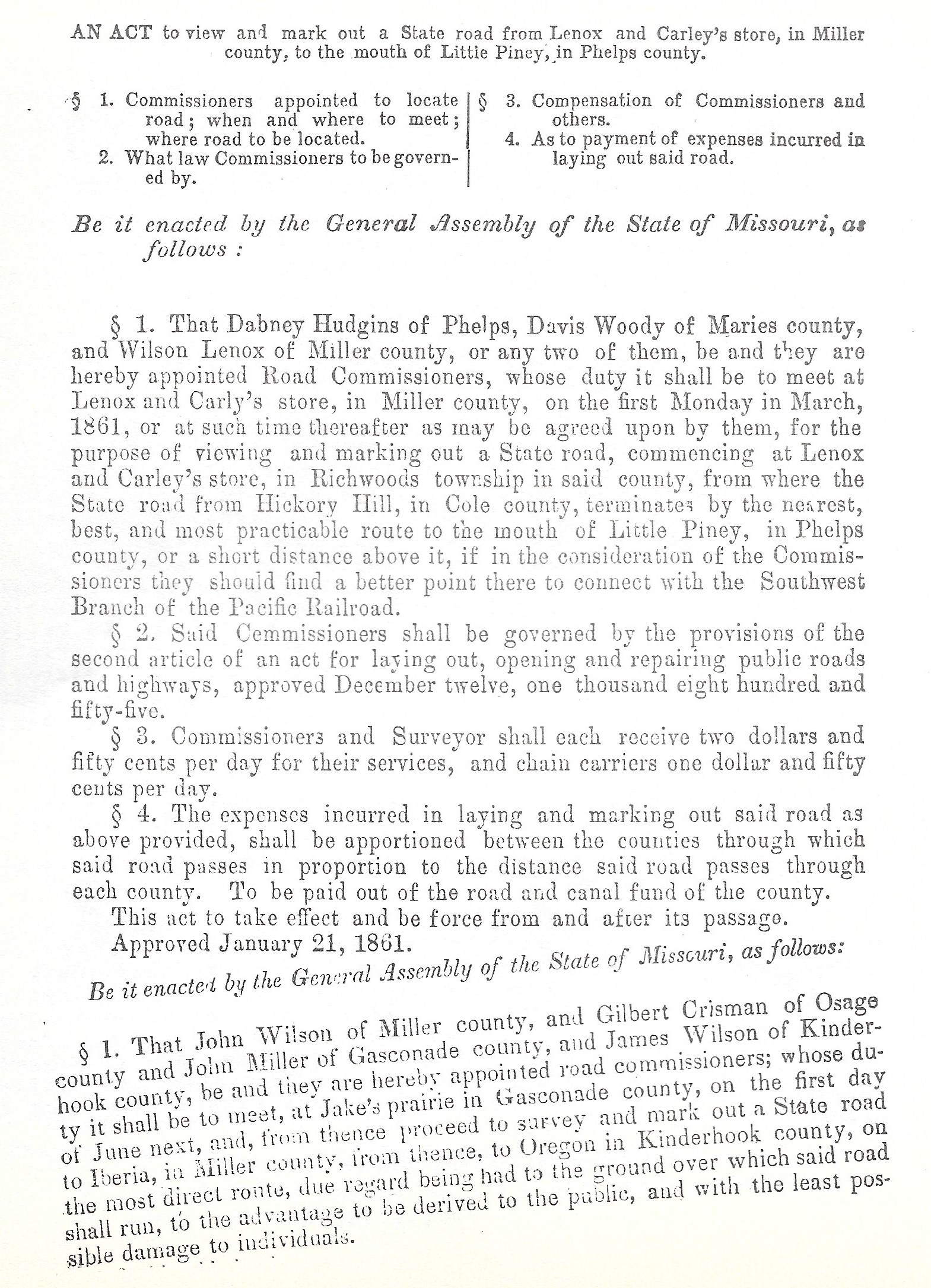
Examples of Legislative Enactment Establishing State Roads
Click image for larger view
In 1837, the year Miller county was organized, the inhabitants were exposed to imminent peril. The Osage Indians, having of a sudden made an unexpected inroad into Southwestern Missouri, were on the warpath. Unable to summon the military force of the United States in time to meet the danger, the Governor ordered a portion of the militia into the field, the only other resource for defense. The savages were repelled happily without much injury.
Fear of a massacre continued on every mind until volunteers in the Big Richwoods in September, 1839, organized the Miller County Militia. On October 26, 1839, the company crossed the river to Muster Day at Tuscumbia. William C. Neely was allowed $10.37 by the State Auditor for the ferriage of this company across the Osage river.1
At the ferry landing, on the north bank of the river, under the hill at the County Seat, Colonel Abraham Castleman, Captains John Bond and William P. Dixon, led the men, dressed in buckskin breeches and leather hunting coats, each man carrying his own Kentucky long rifle, in an impressive parade.
From 1804 to 1847, free white males in Missouri of 18 to 45 years of age were compelled to attend muster. Military drills of short duration were held, but military discipline was very lenient. After dismissal, shooting exhibitions were held, games of skill contested, and feats of great physical strength displayed. Corn liquor, available from big barrels, was consumed freely by everyone, until mashed and broken noses were the order of the day. However, liquor could not be possessed or sold on the parade ground.
In a free-for-all fight, at the August muster, in 1844, at Tuscumbia, James Lamma was killed.
The militia served a very real need in early days when the stealing of a horse was the greatest known crime. It provided a means of training scouts who could follow the tracks of a horse or the footprint of a person like a hound following a rabbit.
Muster Day was also a time for addresses, public announcements, and proclamations. Local politicians often addressed the companies after dismissal. The County Court, having appointed John T. Davis, Commissioner, on May 8, 1844, to superintend the working of the main street in Tuscumbia ordered Captain Davis to give notice of the letting of this work at the Battalion Musters.2
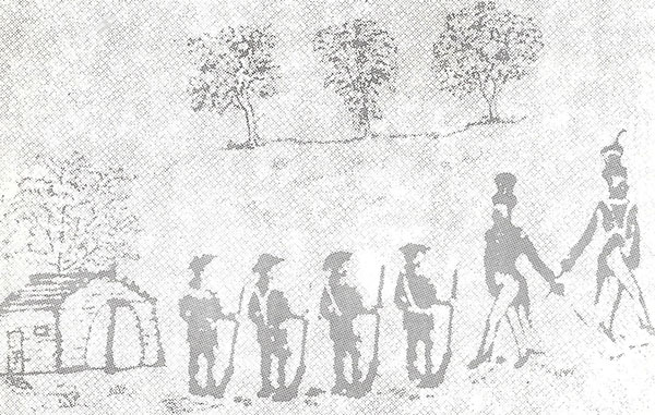
Muster Day at Tuscumbia
Officers wore fancy uniforms
On the first Monday in June, 1844, Captain Davis proceeded to give notice as ordered by the Court, and Colonel Abraham Castleman, bidding the project lowest, at $135.50, solicited militiamen to help in the work. Enough of the men coming forward completed the project by January, 1845.3 The street up the hill, from Dixon’s stable to the Courthouse, was widened.
In the Winter of 1844, Major Josiah Birdsong, with a company of militia, took after a group of outlaws, passing through Miller county appropriating horses, and other necessaries for sustenance. Near the Saline creek, the militia were surrounded, and ambushed. A lively gun battle ensuing, the Major was shot from his horse. Major Birdsong, although conscious when found by his men, was in such a weakened condition he could not rise, his own blood having frozen his clothing to the ground. For this feat of daring the Major was promoted to Colonel; afterward known as Colonel Birdsong until his death.
In 1846, Muster Days were held at Tuscumbia on May 30, June 13, and July 11.
On May 30, the militia assembled at the County Seat about one hundred strong. On horseback, and in full dress, they paraded by the General’s Stand, under the command of Colonel Abraham Castleman; Captain John T. Davis; Lieutenants Champ Smith and Peter Bilyeu.
On June 13, the militia, when dismissed at high sun, were addressed by Generals George W. Miller and Thomas L. Price of Jefferson City.
Again at Tuscumbia, on July 11, the militia paraded under Colonel Josiah Birdsong; Captains John T. Davis and William P. Dixon; Lieutenants Champ Smith and Peter Bilyeu. When dismissed at high sun, each man fired his musket, imitating “the Blaze of glory” of the volunteers for the Mexican War, mustered seven days before, in an Independence Day celebration, at the big spring.
On November 4, 1846, Snelling and Poor, ferrymen at Tuscumbia, were allowed $14.90 by the Miller County Court for crossing the militia over the Osage river; and on November 5, Hugh Snelling was allowed an account against the state for services as ferryman in crossing the Miller County Militia over the Osage river at Tuscumbia, on Muster Days of May 30, June 13, and July 11, 1846.4
Muster Day, held at Tuscumbia the last time in the Summer of 1847, was a scene of pomp and ceremony, attended by citizens from every township. In splendid form the militia paraded; and when finished, troops were drawn-up in formation. Announcements and orders given, the Miller County Militia was disbanded
An Act of the legislature, approved March 3, 1851, ended the local force for all time. This act required the County Courts to apportion the military fund belonging to their counties, among the different school townships, in proportion to the number of children in each township, over the age of five years and under twenty, for the purpose of education.5
1. County Court Record Book A, page 74
2. Ibid., page 187
3. Ibid., pages 200, 211
4. Ibid., page 284
5. Laws of Missouri, 1850, page 246
After the Militia ceased to exist, Patrol Companies were organized. On August 3, 1847, a Patrol Company was appointed by the Miller County Court for Saline township, with Joseph D. Taylor, Captain; Elijah Spence, Stephen Routen, George C. Adcock and William G. Burks, patrol members. They were ordered by the County Court to patrol in Saline township no more than 24 hours, nor less than 12, in each month.1 This patrol was probably established because of the excitement over the Mexican War, but its main function was nigger watching.
1. County Court Record Book A, page 331
In 1850, something happened to the men of Miller county. A strange malady, called gold fever, touched the adult male inhabitants, making them very restless. Nuggets of gold were reported on and under the ground in the western foothills of the Sierras, giving poorer men the greatest opportunities ever known. Miller Countians joined the fierce rush over the plains to California.
Heading Westward
Madison H. Belshe, Boyd Miller, and William Greenup out-fitted an expedition, and with James Z.W. Witten, Elijah Miller, John Stephens, Joseph Hume, Andrew Estes, George W. Claybrook, John Mulky Miller, and others, left Locust Mound on May 2, 1850, for California, going by way of Southwestern Missouri.
Rachel Berry was at the house of James Z.W. Witten the night before Witten’s leaving for California. Wilburn Robbins and Evi Ballengee were there. Rachel Berry said, the nite befor James started fur calaforney, I hurd the parties taulk about renting fur one year.
James Z.W. Witten, and wife, Parallee, lived on the Osage river, southeast from present day Mary’s Home; James having resided on the place since 1838. His farm was considered one of the better places in Miller county. A neighbor, John J. Denton, believed the farm would bring six barrels of corn to the acre. John G. Witten, brother of James Z.W., considered the place a healthy farm, at least, he said, if there is any one on the Osage, it is one of them, for James Witten’s family has been as healthy as any family in Miller county, or more so.
James Z.W. Witten mortgaged this fine farm to raise money for the overland trip to California. Rachel Berry said, James tol evurone he espekted to be gon to calaforney fur to years, that he wud cum back a welthy man. Paralee said, When my husband started for California, he requested me to do the best I could for myself.
My husband informed me, Parallee continued, that I’ve rented the farm to Evi Ballengee, provided Evi does not go to California, he is to take the whole farm, sow one field in wheat, and plant the balance in corn or oats. He is to give the corn three good plowings, with three furrows in each row, and one good hoeing, and deliver one third of all the grain raised on the farm in the crib where directed by me, Parallee concluded.
Hannah Gartin Miller accompanied the expedition, with her children and husband, Elijah, to Southwest Missouri. They lived in Cedar county, having come to Miller county to visit relatives. Their youngest son, Boyd S. was born in Cedar county in 1845.1
For four months the Belshe’ expedition moved across the plains, arriving in Calaveras county California, about the First of September, 1850, near Drytown.
James Z.W. Witten left California for Miller county the next year, without the gold he intended to obtain, arriving home March 1, 1850. Other members of the expedition continued mining for gold, remaining in California for three years. John Mulkey Miller engaged some in land speculation, and in the trading of livestock.
On July 1, 1853, the members of this expedition, with the exception of Madison H. Belshe who returned overland with considerable gold, started from San Francisco, aboard a sailing ship for home. Encountering a severe storm, this vessel was wrecked upon the Pacific coast of Central America. Every person on board from Miller county made it to the shore at Rio Lago. Traveling 800 miles overland to the Gulf Coast, they waited one month for passage to the States, but tiring, embarked on a steamship to Liverpool, England; returning from Liverpool to New Orleans, and from New Orleans traveling up the Mississippi river to Missouri, arriving in Miller county on November 16, 1853.
1. Elijah Miller did not return; he died in California in January 1851
John Melton, Billy Cotten, Thompson (Tom) Howser, and others in the spring of 1850, organized an expedition, leaving for the land of opportunity, California. Attacked by Indians, they crossed the plains in less than four months. At Placerville they found gold in considerable amounts, and hoarded a large quantity. Later, digging for gold on the South Fork of the Yuba river, they were raided once more by Indians so decided to return home. In 1853, boarding a vessel, they sailed down the Pacific coast, landing at the Isthmus. From this landing they walked and boated overland to the Gulf.
Rampaging Indians
While in a canoe, paddling upon a river across the Isthmus toward the Gulf coast, they observed an Indian squaw on the river’s bank, washing clothes; two small children wading beside her in the shallower water. Suddenly, a slapping sound was heard, and upon looking up, the men noticed a huge splashing of water. An alligator, with its tail, having knocked one of the children into the water, grabbed the youngster in its huge jaws. The men, fighting the animal to rescue the child, were unsuccessful. The youngster was devoured by the beast.
Upon reaching the Gulf Coast, passage eventually was obtained by them aboard a ship sailing the Gulf of Mexico to the Mississippi river; the parties disembarking at New Orleans. From New Orleans they returned home by way of the Mississippi.
When their journey ended in Miller county, they had little gold in their possession. Most of the diggins obtained from their mining adventure in the Far West having been confiscated by high fares for passage on various ships.
Thomas M. Winston, George Be Winston, Phillip T. Miller, and Fountaine S. McKenzie, doing business together under the firm name of Winston McKenzie & Company in the Santa Fe traffic and mountain trade, embarked for the California gold fields in the Spring of 1850.
Crossing Saline Township
With a train of 12 wagons they entered Miller county in the first week of May. At the shop of Joseph D. Taylor they stopped, camping for two days on the Saline township prairie. Here, Elisha Shelton, George A. Houston, John Greenup Simpson, Richard T. (Dick) Miller, Robert Reed, Joe Thompson, and others joined them, including a number of negro slaves.
When Fountaine S. McKenzie, the trail boss of this outfit, yelled wagon’s ho approximately forty vehicles commenced rolling, and as many riders moving, westward toward Salt Lake City. On the Kansas prairies, some of the riders moved ahead, leaving the train.
The train itself moved rather slowly, taking over four months to cross the plains, via Salt Lake City, to California. On August 30, 1850, Winston McKenzie & Company, with others, arriving in Eldorado county, in the State of California, camped at Hangtown for several days.
Phillip Miller said, “When I arrived at Hangtown, I was much worn out with the fatigues of the journey. Dr. Miller, a Nephew of mine, resided in Hangtown. I went for him to see about a negro of mine who was sick, and afterward died. Dr. Miller’s shop was at the end of the street near a cliff of rocks”
Richard T. (Dick) Miller, afterward a Judge of the Trinity County Court in California, said, “I came across the plains from Missouri to California in the year of 1850, in company with F.S. McKenzie and G.B. Winston. We arrived in Eldorado county, California, about the 1st day of September, and camped at Hangtown, for several days.”
“The condition of the animals,” he continued, “at that time was not good. They had been brought across the plains, from the State of Missouri, and were poor. We had traveled slow in crossing the plains, but Winston McKenzie & Co.’s stock were in much better condition than stock usually are immediately after reaching California from the plains. Good fat mules, and horses, in September, 1850, in California, were worth from $150 to $300. Good horses and mules just arrived across the plains were worth, at that time, from $75 to $150.”
Phillip T. Miller said, “We started with 27 head of company stock. Got two off Berry on the way, and another at Salt Lake City. Sold one and gave one away between Carson Valley and Hangtown. There were seven mules, the remainder horses.”
On September 12, 1850, while camped at Hangtown, in “the County of Eldorado, California.” George W. Bolton said, “Peter Taylor and Joseph T. German, came to the camp and solicited of Winston McKenzie & Co. a contract for herding or ranching their stock.”
“They said they had a ranch on Dry creek.” Richard T. Miller continued, “about forty miles from Hangtown, on which there was fine grass, and on which they were then herding, or ranching, a large number of stock. They advised us to put our stock on their ranch saying that it would soon fatten them, and put them in good order for sale or service.”
“The next day it was agreed Winston McKenzie & Co.’s stock would be taken by Peter Taylor, and kept at his ranch.” George W. (Wash) Bolton said, “for the consideration of four dollars per month for each animal. They took McKenzie’s stock at Hangtown. There were 15 horses and six mules. Others also sent animals to the ranch. Taylor taking about 40 head in all.”
The men of the wagon train, dispersing, engaged in mining near Hangtown or Placerville in Eldorado county, also on Big Dry creek, and Sutter’s creek in Calaveras county. Much gold was found, and on December 11, 1850, Fountaine S. McKenzie sent to the ranch for his horses and mules, so preparations could be made for a return journey to Missouri, with their diggings.
Waiting three days for a reply, and none coming, McKenzie, Dick Miller, and George Washington Bolton went to the ranch. Upon demanding their horses and mules, they were informed that William Amick, William Meador, and George Legon were in charge of the ranch; Peter Taylor and Joseph T. German having returned to the Atlantic States; Morgan county, Missouri.
Amick, refusing delivery of their horses and mules, would not even assist in hunting the animals for, he said, “the animals have strayed off, been stolen by the Indians, or others, some having died.”
McKenzie, Miller, and Bolton commenced searching the ranch for their stock. “We searched in every direction,” Bolton said, “for the space of eleven days, and we found seven head; 3 mules and 4 horses, which was all we could find, and some of these were scattered for a distance of twenty-five miles from the ranch, with none of the animals found on the ranch of Taylor.”
In the District Court of Trinity County, California, at Weaverville, Winston McKenzie & Co. sued the Taylor Ranch on Sutter’s creek, for damages. In a cause of action, “Plaintiff (Winston McKenzie & Co.) aver that in consequence of said defendants (Taylor Ranch) neglecting and refusing to deliver the aforesaid animals when requested so to do, that said plaintiffs have sustained and been damaged to the amount of three thousand dollars over and above the value of the aforesaid animals, (an amount of $1,750.00) and for the loss of time and expenses expended to procure and purchase other suitable animals for the uses and purposes of said plaintiffs in and about their ordinary and usual business, and also the great interest of the value of the capital invested for said animals, an action has accrued to the plaintiffs to demand and have of and from the defendants the sum of Four Thousand Seven Hundred and Fifty Dollars, besides cost of suit.”
September 4, 1850. Received of Winston, McKenzie & Company:
One bay mare, 7 years old, 15 hands high, roached mane.
One bay mare, 8 years old, 14 ½ hands high, blaze in the forehead.
One bay mare, 9 years old, 15 hands high, blaze in the forehead, roached mane, left hind foot white
One brown mare, 6 years old, 15 ¾ hands high, short foretip, roached mane, small star forehead.
One brown, 15 hands high, mare 7 years old.
One black mare, left hind foot white.
One black mare, 10 years old, 14 ½ hands high, blaze the forehead, and small white spots on belly.
One dun mare, 4 years old, 15 hands high, branded on the left shoulder with heart.
One brown mule, 3 years old, brand on left shoulder SG
One light brown mare mule, branded HW on the right shoulder, split in the left ear.
One pided mare mule, 3 years old, branded SG on the left shoulder.
One sorrel mare mule, 3 years old, branded HW on right shoulder.
One horse mule, black, branded SG on the left shoulder.
One mouse mule, 3 years old, branded SG on left shoulder.
One brown mule, 3 years old, branded SG on left shoulder.
To be herded on our ranch situated on Sutter Creek at the rate of three dollars per head per month, all branded on the left shoulder with the figure (12) which is our ranch brand.
Peter Taylor
George Legon
William Amick
William Meador
Joseph T. German1
When action on this suit commenced in District Court, Peter Taylor and Joseph T. German, having returned to the Atlantic States, could not be found, nor George Legan, William Meador, and William Amick, even after publication of a summons in the Shasta Courier once a week for three months and posting copies of the summons in the post offices as required by law.
Not answering the complaint, the Hon. District Court of the 8th Judicial District in the County of Trinity, California, awarded damages, by default, “for it manifestly appears to said Court that the said Plaintiffs have sustained damages to two thousand seven hundred and fifty dollars, besides costs in money and disbursements by him about this suit in his behalf expended. Therefore, it is considered a conclusion of law, that the Plaintiffs recover against the said Defendants damages to two thousand seven hundred and fifty dollars and two hundred and nineteen dollars and fifty cents for his costs and disbursements.”
Winston McKenzie & Co. recovered nothing. The ranchers having disappeared, the ranch was out of business; the company’s mules and horses having vanished.
Milton A. Houston, George W. Bolton, Elisha Shelton, John Stephens, and William Shelton having employed Taylor for ranching their mules and horses in 1850, “never saw them again,” they said.
Later, Winston McKenzie & Co. sued Peter Taylor in Morgan County Circuit Court, at Versailles, Missouri, to receive damages in the same cause.
On August 30, 1859, at Versailles, Alfred Amick said, “I was in California in September, 1850. I remained there until January, 1856. I was on the Taylor ranch at the time Winston McKenzie & Co.’s stock were upon the ranch. I assisted in taking care of the stock, and remained upon the ranch until the stock were taken away. The stock were herded and ranched with the same care and attention given by others at the time, and none of the stock were lost off the ranch by neglect.”
“At that time,” Amick continued, “it was almost impossible to prevent the loss of stock for the country being new, notwithstanding good care and attention, stock often strayed away for there were no fences, or were stolen. There was a gang of thieves detected upon an adjoining ranch, broken up the latter part of 1850; and it was even ascertained the thieves used another ranch in a distant part of the country.”
“It was a general rule that ranchers were not responsible for the loss of stock unless insured, in which case, a higher rate for ranching was charged. This general custom was known by stock traders,” Amick concluded.
Milton A. Houston said, “I resided in Amader or formerly Calavares county, California, in 1850, and have most of the nine years since. Joseph T. German and Peter Taylor ranched stock for me in 1840, and the stock were lost, and from my understanding of the rules and custom of the country I had no recourse to recover such loss.”
Judge Richard T. (Dick) Miller said, “Some time during the month of October, 1850, I went to the ranch of Taylor & Co., on Dry creek in California, to examine some stock which I had placed on it to be herded. When I got to Taylor & Co.’s ranch I found William Amick and George Legan in charge of it. I spent two days upon the ranch hunting for my stock. Amick and Legan assisted me in hunting up my stock. Amick, I think, told me that Taylor and German were still at Hangtown. I found the stock on the ranch much scattered. There was no one herding or attempting to keep the stock together. There was no corrals or fences of any kind on the ranch. I found some of my animals straying four or five miles from Taylor’s & Co.’s ranch.”
Eventually the case against Taylor’s ranch reached the Supreme Court of Missouri. Winston McKenzie & Co. lost.
This company freighted to California, and the Far West, until the Civil War.
Most of the men from Miller county, and Central Missouri, going to the gold fields in 1850, eventually returned home.
Joseph Hume went to California in 1850, “and I remained there 5 years and 3 months.” He said. “I was all over the State. I kept a ranch on the Sacramento river, below the city, about 18 months. We hunted up stock once a day, and if any were gone we hunted them up. Only lost 4 or 5 head the time I was there.”
Robert Reed resided for some time in Calaveras county, and engaged in ranching. “The country was entirely new.” He said, “and unfenced. The country at that time was greatly infested with thieves and a great deal of stock were stolen and driven off. There were not many Indians.”
Andrew Estes also engaged in ranching. “Ranches there were just claims on which stock were kept without enclosures,” he said. “There were no corrals; the Spanish custom was to lasso the stock on the range.”
John Stephens said, “I was in California in 1850. I went to Hangtown, from there to Drytown, then to Dry creek, and other places. I met Gabriel Cotten, and others from Missouri, in 1850, and told them it was the custom of ranchers to look after stock during the day, but not at night.”
William Shelton said, “I was in California at the gold diggings. I was on the Taylor ranch once in March, 1850. There was no corral on the ranch, only a small house. I lost some stock there.”
John Greenup Simpson remained in California, and served as Chairman of the Board of Supervisors (County Court) of Fresno county, California, a number of years.
It appears most of the journeys from Miller county to the Far West were undertaken in summer months. Other citizens did not fare so well. In the Winter of 1850, citizens were found on the death trail to California, from every state in the Union, Missouri especially. Captain William Waldo, a citizen of Missouri, went to the aid of emigrants sorely afflicted with famine and disease on the latter part of the California trail.
John Crismon, who married Flavilla Melcena Brashears, a daughter of Reverend Joseph Brashears,2 almost lost eleven brothers and sisters while with a wagon train in 1852, going West. Poisoned with alkali water, two of John’s brothers, and a sister-in-law suffered death immediately. Other members of the family, sorely afflicted, rallied from the lethal dose; recovering. The bodies of the deceased were buried in a wagon box ahead of the train so that when the last wagon passed over the site, no trace of the grave remained.
1. The above livestock were found by McKenzie, and others, on the Taylor & Co. ranch; copying from their agreement.
2. Reverend Joseph Brashears was an early day preacher of the Methodist Faith in Miller County
On March 23, 1850, a meeting was held at the house of Judge Edmund Wilkes in Saline township. Neighbors Gabriel Cotten, Elijah Spence, Isaac Bunker, John Furney, Benjamine F. Cotten, and Silvester I. Cotten were there, and Daniel W. Bliss of Morgan county. After a lengthy discussion, they formed a partnership, by the name and style of The California Gold Diggin Company for a term of two years, from and after the 10th day of April following.
The agreement read: “Be it remembered that on this day being the Twenty Third day of March Eighteen Hundred and Fifty, the following article of an agreement was entered into between the following persons (viz) Gabriel Cotten, William Cotten, Isaac Bunker, Benjamine F. Cotten, Elijah Spence, Silvester I. Cotten, John Ferna, and Edmund Wilkes, all of the county of Miller and state of Missouri, and Daniel W. Bliss, who is a resident of Morgan county, Missouri, aforesaid:
“That is to say Gabriel Cotten, William Cotten, Isaac Bunker, Benjamine F. Cotten, Elijah Spence, Silvester I. Cotten, John Ferna, Daniel W. Bliss, do agree to form themselves into a company to be known by the name of The California Gold Diggin Company, for the term of two years, from the Tenth of April next.
“The said Gabriel Cotten, William Cotten, Isaac Bunker, Benjamine F. Cotten, Elijah Spence, Silvester I. Cotten, John Ferna, and Daniel W. Bliss doth agree and bind themselves to set for the gold diggings in California, on the Pacific side of the Rocky Mountains, on the 10th day of April next, or as soon thereafter as the grass will maintain their stock. And when they arrive there, each one of the company binds himself to engage in the gold digging business, and do all other things whatsoever, that a majority of said company may decide would be to the advantage or interest of said company for and during the term of time above specified.
“Each individual pays his proportionate part of the outfit, and when said company arrives in California, that portion of the outfit that a majority of said company decides they have no use for, may be sold for the benefit of said company.
“The said company doth further agree that after signing this obligation, if there should be any individual of said company fail or refuse to go on with said company, that they do forfeit all of their outfit to said company.
“The said company doth further agree that at the end of the above specified time, and when said company may have landed at home in Miller County, Missouri, that we will equally divide all of the net proceeds of said company amongst all of the members thereof. Now the above mentioned Elija Spence doth agree and bind himself to pay to Edmund Wilkes the just and full amount of one half of his share, in consideration of the said Wilkes furnishing said Spence with his outfit for California.
“Now we the said company doth agree, that although some of our company may take sick, after we set out for California, or during the said two years, or even die, yet their heirs or representatives shall be authorized to draw their equal share of said company. We further agree that should a majority of said company desire to come home, after they shall have arrived in California, short of the term of two years as above specified, they shall have the privilege so to do, and if any member of said company desire, after the dissolution of the same, (or said company) by reason of this Article, he shall be entitled to receive his share of the net proceeds of said company in California, if desired. Signed and subscribed this the day and year aforesaid.”
Preparation for the journey commenced. Gabriel Cotten informed his wife, Margaret, “take good care of yourself, and the youngun’s, and if Ben and Sil and myself can come back with three or four kegs of gold, we will have nothing to worry about for the rest of our time.”
On May 10, 1850, Gabriel Cotten, William Cotten, Elijah Spence, Isaac Bunker, John Furney, Daniel W. Bliss, Benjamine F. Cotten, Sylvester I. Cotten, and other men, left Miller county for the Pacific side of the Rocky Mountains; having a difficult journey. About half way to California, on the Green river road toward Deseret, they were attacked by Indians, and Daniel W. Bliss was killed.
Recovering from this tragedy, the balance of the company proceeded on to California, with the remainder of the partnership effects, arriving at the gold fields on September 6, 1850.
After mining for gold on the lands of the United States and others, without leave, for three weeks, the company was dissolved by the members. The partnership effects, amounting to $1,020 in gold dust and coin, were divided into seven equal parts. Although most of the outfit belonging to Daniel W. Bliss had been captured by the Indians, an ox and a cow belonging to him did reach California. The members of the company believed it as much as the worth of the stock to have moved them on to California with the rest of the train. Bliss was voted no share.
On September 26, 1850, Gabriel Cotten, Elijah Spence, Silvester I. and Benjamine F. Cotten left the gold fields for Miller county.1 Before leaving they received, as did others of the company remaining in California, $145.71, each, in gold dust and coin, the full and fair distributive share of the proceeds of the dissolved company.
The journey home for the Cottens and Spence was a very difficult one. It cost Gabriel Cotten, $300, to get from California to Miller county; Elijah Spence, $200. And upon reaching home they were served with a summons, by the Sheriff of Miller county, to appear before the Judge of the Miller Circuit Court “on the first day of the next term to be held at the Courthouse in the town of Tuscumbia on the Thursday after the Second Monday after the fourth Monday after the fourth Monday in March, 1851.”
Daniel Bliss, administrator of the estate of Daniel W. Bliss, deceased, having instituted a civil action against Gabriel Cotten and Elija Spence, in Circuit Court, believed Daniel W. Bliss entitled to a one eighth part of the proceeds of the company when dissolved in California.
At the April Term, 1851, the Hon. Circuit Court, heard the cause, and a jury composed of William A. Shelton, William Hawkins, William R. Beard, Lawsewell Wright, John Richardson, Jas. Reed, John Davidson, John Henderson, Presley Hawkins, Abraham Golden, John L. Fulkerson, and James M Wyrick, twelve good and lawful men, rendered a rather unique, Special Verdict, as follows:
“We the jury find that the plaintiff’s intestate entered into the contract filed with the petition with the defendants and others therein mentioned, which contract we make a part of our verdict. That the parties started for California and that the plaintiff’s intestate died on the road to Green river about half way to California; that the balance of the company proceeded on to California with the partnership effects, that they got there about the 6th day of September, 1850, and engaged in mining for three weeks. That the company was then dissolved and the partnership effects amounting to $1,020.00 in gold dust and coin was divided into seven equal parts of which each of the defendants in this suit took one part that is to say each took $145.71 in gold dust and coin. We further find that of the stock put in by the deceased an ox and a cow got to California, and some other property, the value of which we are unable to ascertain; that it was as much as the stock was worth to take on to California from the place where the said Daniel W. Bliss died. That the company mined on the lands of the United States and others without leave; that the defendants started to Missouri from California on the 26th of September, 1850, and also the said Silvester I. Cotten and Benjamine F. Cotten, and that the balance of the company except the deceased remained in California and took their above named share of the above named sum of money there. We further find that the Plaintiff administers on the estate of the said deceased as alleged in his petition. We further find that it cost the defendant Gabriel Cotten $300 to bring him home from California to Miller county, Missouri, where said contract was entered into and that it cost the defendant Elijah Spence $200. If upon the whole facts the Court shall be of opinion that the law is with the plaintiff then we find the issue for him. If on the contrary the Court should be of opinion that the law is for the defendants then we find for them.
William G. Shelton, Foreman”
Upon receiving the verdict of the jury, the Honorable Circuit Court rendered its judgment:
“Whereof the Court is of the opinion that the law is for the defendants and the plaintiff on the facts found is not entitled to recover from the defendants. It is therefore adjudged by the Court that the defendants go hence without day and that they recover from the plaintiff their costs and charges by them about the defense in their behalf lain out and expended.2
1. John Stephens met the Cottens in 1850. Stephens went to Hangtown, from there to Drytown, then to Dry Creek and other places. He reported the Cottens were very tired, worn, disappointed.
2. Circuit Court Record Book A, page 244
In 1850, Jeremiah Vernon was living in a double-log house where Olean now stands, enjoying a higher mode of pioneer existence than most of his neighbors.
His wife, Betsy, a daughter of Judge James Stark of the County Court when territory north of the Osage river belonged to Cole county, was a woman of high moral worth; possessed of many rare qualities of mind and heart.
They were the parents of sixteen children; eight having reached maturity when the news arrived in Central Missouri that nuggets of gold could be found upon the ground in California.
However, a loving wife, eight children at home, warm hearths in a comfortable pioneer mansion, and a promise of more comfortable days to come, were not sufficient, although reasons valid enough in every other case, to hold Jeremiah Long upon catching the fever, like others, he must go West and strike it rich!
Preparation for the westward journey commenced early in the Spring of 1850. For his wagon Jeremiah constructed a new, sturdy box, installing stout bed bows upon it, then stretching the strongest sail cloth he could find over them. At Joseph D. Taylor’s shop, on the prairie, in Saline township, other wagons were inspected, dismantled, and repaired.
Jeremiah installed new bed bows and covering
George Stubblefield, James Taylor, William Stubblefield, Wm. Long, Tandy Moore, and others, with Jeremiah gadding his best bull team, left Saline township for the gold fields in May, 1850.
Moving toward the Far West through McCasland’s Gap, perhaps a few anxious moments crossed the minds of the travelers, with homes and families now falling behind them, but any forebodings of leaving disappeared in the honest beliefs of instant wealth.
Crossing the plains without incident, half-way upon the Deseret road, Jeremiah commenced ailing. Each day, along the trail, his condition continued worsening until, having arrived in Eastern California, Jeremiah succumbed to fatigues of the journey, and bright’s disease.
Jimmy Taylor, Tandy Moore, and Mr. Long, dismantling a portion of Jeremiah’s new wagon box, constructed of the lumber a sturdy coffin. Opening a grave near the train, the body of Jeremiah was interred by his comrades, beside the trail, in simple, but solemn services.
Early in October, the remainder of the train arrived at Hangtown, California.
“When we got in,” George Stubblefield said, “the stock were very, very thin, and the men were as gaunt as the beasts burdening the train.”
It may be written over one-half of the adult male inhabitants of Miller county traveled to California’s gold fields in the 1850’s. When touched with gold fever, nothing in the long run could avail to prevent anyone from going, but upon returning home, although considerably worn out from fatigues of the journey, and generally in a worsened financial condition than before leaving, the fortune hunters were considerably enlightened. Having traveled extensively they possessed fuller knowledge of the vastness, rugged beauty, and potential for development upon the plains and in the mountains toward the Pacific.
Things would never again be quite the same. Far west, an appeliation for frontier life in the wilderness in its fullest and most significant meaning, was no longer applicable to Miller county. Missourians, and others, having pushed into buffalo country, the deserts, and mountains, to the shore of the Pacific Ocean, set off the nation’s frontier line of settlement galloping toward the dusk.

In the Summer of 1838 eight horses belonging to Felix Barnhart, entering an enclosure near the Big Tavern creek, destroyed a field of maize being cultivated by Daniel Brumley for grist. Daniel informed neighbor Felix something would have to be done about it; having lost a winter’s supply of meal.
Submitting the matter to arbitration, it was determined “By an agreement of the parties, we met on the 8th day of September, sworn to stand the verdict of three men, whom were sworn to it, that is, Sherwood P. Record, Josiah Stewart, and Josiah Birdsong.”
Josiah Birdsong, one of the referees, was chosen by Daniel Brumley. Josiah Stewart, one of the referees, was chosen by Felix Barnhart; Sherwood P. Record the referees’ choice. It was agreed to enter the evidence and referees’ award as a judgment in Squire Jesse Kendrick’s Justice of the Peace docket.
“Witnesses attending the first day, James Brumley, Hugh Snelling, Silas Capps, John W. Davis, and C.W. Roberts. Witnesses attending the second day, Adam Shirley, Jesse Boon, Silas Capps, J. Barnhart, James Brumley, C.W. Roberts, John W. Davis, Hugh Snelling, William Blize.”
The verdict of the referees was that, the defendant, Barnhart, pay the plaintiff, Brumley, for damages, $62.50; justice fees, $2.81; and officer’s costs, $3.25.
Not having the money, Barnhart asked for time, and it was granted “Upon a judgment this day rendered in favor of said Burmley against said Barnhart for $62.50 damages and costs; this day comes the said Barnhart and prayed a stay of execution for four months which was granted to him by William Blize becoming his security according to law, this 9th day of September, 1838. Jesse Kendrick, J.P.”
In January, 1839, the four month' term of the condition of the security given by William Blize having expired, Daniel Brumley went to Kendrick for settlement. Immediately, Squire Kendrick commanded the Constable of Richwoods township to levy the amount claimed by Daniel Brumley on the goods and chattels of Barnhart and Blize.
Upon finding that Barnhart had left the county, Squire Kendrick, Daniel Brumley, John W. Davis, and Constable C.W. Roberts proceeded to the house of William Blize, and by direction of Brumley, seized upon and carried away two yoke of steers, and the yokes, two heifers, one cow and calf, one unbroken steer, one bell, one chain, and other property to the value of $114.
Later, in Circuit Court at Tuscumbia, Blize recovered from Squire Kendrick, Brumley, Davis, and Roberts, in an action of trespass, $150 in damages. Brumley, appealing to the Supreme Court of Missouri, lost!
On August 4, 1840, in Tuscumbia, at the Courthouse door, Sheriff Harrison offered for sale two yoke of oxen, three cows and their calves, property belonging to Daniel Brumley, standing nearby.
Receiving no bids for the animals, Jesse Kendrick handed $77 to the Sheriff, and afterward, the remainder of the judgment, to Blize.
Daniel Rainwater stated that on the 8th day of December, 1840, “I had went up into the bottom above my plantation,1 and just as I crossed the fence into the field I heard a horse snork. Advancing upon the nag, I found my sorrel horse at the crib. A gray horse about fifteen hand and one inch high had been taken out of my inclosure. I tracked him and another strange horse about two miles and I came to whether the other horse had been turned in the corn field. The fence had been laid down and put up again. I found where the gray horse had gone back to the road. Later, I learned a man had passed Golden’s leading a horse answering the description of the one missing. I then went to Golden’s2 house, ten miles away. There I took the back track of the horse which I believed to be my gray horse’s track, apparently led by another horse. I tracked them back about half a mile which direction corresponded with the direction on which I first tracked them. I then took the former track. They crossed the main road at the corner of Golden’s fence, then took a rather south direction through the woods. Soon after that I got information of a man crossing the Osage at Tuscumbia, leading a horse answering the description of my gray horse. I pursued.”
Anne Bilyue saw the rider and horses passing through the Little Richwoods. She was at Isaac Bilyue’s house. She thought one of “the horses of a dark color with some dapple.” Issac Bilyue said, “the man had on a drab colored coat with some two or three capes. He had come in a direction of Emly Goldens.”
John Brumley, coming to Tuscumbia early in the morning, after passing Noah Hudson’s place, saw a man with a red beard lying by a fire, near two horses tied by the side of the road. One was a sorrel horse and one a gray. Some time later, William McCubbin, riding by noticed the man and horses.
At daylight Charles Carrender, ferryman at Tuscumbia, crossed the man and two horses over the river. Unable to pay the three bits ferriage, the man gave Mr. Carrender a good knife for compensation. Carrender said “he inquired the road and distance to Boonville. I told him it was called sixty miles. He then inquired the road and distance to Jefferson. He then inquired the distance to the Mississippi. He took the Jefferson Road.”
Daniel Rainwater, appearing at the ferry landing shortly before day, had a paper, issued by William Tinsley, a Justice of the Peace, to apprehend forthwith, take, and safely keep the felon; so a posse was organized.
Daniel Rainwater, John Brumley, William McCubbin, and others of the Mustered Squads, with Emly Golden as scout, rode north, following horse’ tracks past Elisha Francis’ old camp, past Josiah Birdsong’s improvement, to the house of David Enoch. Here the company took the man with a red beard, and two horses. Red Whiskers, bound by the men, was led with the horses to Harrison’s at Tuscumbia, to be dealt with according to law.
At sunset, Red Whiskers could be found under the hill at Tuscumbia, on the North bank of the Shut-In branch, hanging from the end of a rope in a large elm tree.
1. Rainwater’ Plantation situated in Kinderhook county
2. Emly Golden, in Glaze township
Friday morning, February 25, 1845, Daniel Etter met James Scarberry between Tinsley’s place and Bowlin’s Mill, in Glaze township.
“Scarberry informed me he was going to Tuscumbia,” Daniel said, “and wanted to know if he was in the road leading by Emly Golden’s? He was riding a sorrel beast. He had something under him, like a sack or a bag.”
Friday morning, Andrew Golden, on his way to Bowlin’s Mill, met Scarberry “riding a sorrel horse, or I took it to be one; and he was carrying a gun,” Andrew said.
James Scarberry, Hesiah George’s hired man, was receiving $75 a year for his labor, plus board and keep.
Most of the day Friday, Hesiah George, his wife, Jane, and their hired help, were on the plantation, out of the house, performing usual toil.
“The children informed me,” Hesiah said, “upon coming into the house of Scarbery’s having taken a horse, and leaving to borrow meal. We thought nothing of it until my wife found a shirt missing off the rack, and upon examining things, I noticed a guord, containing more than one pound of gunpowder, and then, my gun, were missing. A sack on the wheat garner was gone.”
“Sunday morning, Scarberry having not yet returned, I grew suspicious he had stolen my horse,” Hesiah concluded.
Very early Sunday morning, ex-sheriff Wm. N. Harrison, Samuel Ulman, A.Y. Carlton, Joseph Ulman, Joshua R. Shockley, Andrew Golden, Daniel Etter, and Hesiah George were riding horseback, rapidly, over Glaze township, looking for James Scarberry.
At the house of William Webb, they lit a-running from their horses, and without leave, searched the premises. Upon entering the stable, Hesiah found his horse. Hesiah inquired of Mr. Webb where James Scarberry might be found? Webb informed Hesiah he was soundly sleeping on a stead inside his house.
“I seen Scarberry at the fence upon coming home Friday,” William Webb informed Sheriff Harrison, “and I asked of him What in the world brought you here?”
James Scarberry, as a horse thief should be, was rudely awakened from sleep by loud conversation, and kicked out of bed by Harrison.
In June, 1849, a man rode up to the house of Judge Edmund Wilkes, in Saline township, and upon introducing himself, informed Edmund that Thomas L. Price, of Jefferson City, was a close, personal friend. Judge Wilkes, intimately acquainted with Thomas L. Price, rode horseback with the man to many places in Saline township. They rode to Mr. Elliott’s house, and while at the place, talked about trading a horse.
Judge Wilkes said, “We were several days talking about the trade of a horse or a deal for one, and the bargain was concluded after going to Mr. Elliott’s. A note was assigned to me, and my horse delivered on the 22nd day of June, 1849.”
Here, Judge Wilkes, loaning the man a saddle, bridle, and blanket to ride to Jefferson City, was promised that, upon his arrival at the capitol town, the property would be returned to the Wilkes’ residence or to Mr. Gracia’s in Morgan county, by the first stage running from Jefferson City to Versailles.
“But instead of going to Jefferson City,” Judge Wilkes said, “he turned about and took the road to Springfield. He staid all night at the widow Robertson’s on the Big Gravi, eleven miles South west from my house. On the next day he continued on South, and crossed the Osage river at Mrs. Crane’s ferry. That night I learned the route he had taken, and sent two gentlemen after him.”
Andrew McCastland and Jacob W. Hallfor, with instructions to apprehend the man, rode south. They were joined along the way by other gentlemen, until eighteen riders were galloping full-speed toward Springfield.
The man said, “Since the 22nd I rode within 32 miles of Springfield, and on Monday, about four o’clock, I put up to feed my horse on the public road to Springfield at Mr. Roper’s in Dallas county. About seven o’clock, Hallford, McCastland, and two other citizens rode up to the house where I had put up. At the same time some dozen or fourteen men rode up to the house, and lit off their horses. Hallford and McCastland came in. McCastland was very steady. Hallford wanted my arms,1 and wanted to take me right back. I asked Mr. Hallford if he was deputized to take me, and he said not. I told him he could not take me nor my arms until they had taken me before a Justice of the Peace. He assisted to take me and my arms. And they did!”
Bound and tied to the saddle, the man was carried to Pleasant Mount, and there, on June 28, 1849, Samuel J. Jones, a Justice of the Peace, committed him to the Miller county jail, “there to remain until he be delivered by due course of law.”
1. Pistols
The early settlers in Miller county were very uneducated by today’s standards, for most could neither read nor write. Feasting, hunting, and feats of great physical strength were the main employments. In rainy weather, and winter evenings, they played with their hunting dogs, cleaned their guns, and sharpened their knives and axes.
But in the ways of living in the Wilderness, these early settlers, and their children, were extremely educated. Through the eye and the ear and the senses they acquired from their surroundings, and by valuable life experiences, the necessary information for survival in the earliest times of which history gives us any account.
Without the environment for exciting or even keeping alive feelings for survival in modern times, people presently have no way of even minutely understanding the discipline of the Wilderness upon the earliest inhabitants.
Many stories were seriously told, and implicitly believed by children, about cunning panthers, savage wolves, ghostly Indians, and peculiar haunts in the wild woods. It is known the people were very superstitious. Any occurrences which they could not fully comprehend actually terrified them.
On Christmas day, in December, 1840, early in the morning, Fountaine T. Hudson, rushing into his father’s house, informed Noah a huge bear was rustling near the head of the hollow opposite the Cat Tail branch from Dog creek. “Will you help me get him, pap?” Fountaine inquired.
Noah, somewhat indisposed, for it was Christmas morning, refused to go after the critter. The temptations of the hunt, however, exciting Fountaine so greatly that, after many earnest entreaties, his father obliged him to go alone after the beast.”
“Take old Boone hound, and the rest, but let Daniel lead, and be careful, boy,” Noah said. “Let Daniel have the first move, then old Boone will nab a chunk, and keep a worrying on him till he stands.”
Almost immediately Fountaine rushed from the house, carrying in one hand a powder horn; a worn, but accurate and trusted, Kentucky long rifle in the other. Noah, possessed of an afterthought, stepped into the door, hollering to his son, “If you ride the nag, boy, stay down breeze from the bar.”
Noah Hudson lived on the Dog creek where the house, better known as the Alvin Wyrick ’place, presently is situated. His son, Fountaine T., mature in person, and very strong, was 16 years of age. Neighbors told the youth was remarkable for his swiftness in walking and running. At the stable, Fountaine T. Hudson carefully tamped an ample bar load in old Kaintuck. He then threw the green blanket over the nag, taking the halter reins in hand, and on foot, setting out, leading the nag, restraining Boone hound on a leash fastened to his waist cloth. Daniel hound, up front, commenced leading the pack in a chorus of anxious tongues toward the hollow which Hwy. 17 presently descends to the Dog creek.
Near the opening of the hollow, Fountaine heard the hounds, near the head, in full cry, rapidly setting off over the ridge into the valley of the Dog creek, continuing northeast, into the breeze. Boone hound strained every muscle to break away from his master, and join the chase. Finally, as Fountaine moved to free him, the youth noticed the hound’s huge frame quivering in anxious anticipation of coming great excitement.
Unleashed, Boone bounded away, instantly calling down the creek to others of his kind, loudly and clearly, that he was coming. Fountaine immediately, jumping astride the nag, pursued the hounds, using the familiar bear, deer and wild hog paths to pass rapidly through the primeval wilderness in the valley of the Dog creek.
From one side of the creek to the other the chase continued until, where the stream suddenly bends toward the Osage river, the hounds ceased their cries. Stopping and listening some moments, Fountaine was apprised of the events ending the chase. Wild hogs were barking in every direction. The bear, having scattered a huge gang of wild hogs, stirred the hazel-splitters into scattering the hounds.
A wild porker coming over a little rise, stopped quickly, viewing the nag and rider with much curiosity. Fountaine, raising old Kaintuck, placed a bar load between the hog’s eyes, which felled the critter without a squeal. Dismounting, and opening the porker’s throat with his knife, Fountaine busied himself making a pole skid to drag the hog home. Then it happened!
Toward the Osage river, a great beast bellowed lustily. The youth had heard many panthers, but never an animal like this one. His hair wanted to rise, then stood, for the great beast called again. It even seemed much closer. For the first time in his life, the youth’s undaunted spirit forsook him. His knees weakened so, he almost sank fainting to the ground.
With much difficulty he got astride his mount. Finding himself excited, he put heels to his nag, and galloped off, but becoming faint from fear, fell from the nag, and was dragged by the halter reins till his hand came free. When revived, he heard his nag a-running up the creek, and fled after it.
Sometime later, Fountaine T. Hudson bashed in the door at his father’s house. He stood before his father, his complexion paled, clothing torn, his body bleeding and whelped from cuts and bruises. He breathed with great difficulty, having very rapidly ran two miles.
“What’s the meaning of this, boy?” Noah inquired, excitedly.
A terrified youth informed his father there was a great beast, like never before known, coming up the Dog creek valley! Its scream was heard twice! It almost shook the ground! Bigger than the largest panther; moving fast!
The condition of Fountaine, for he was a very brave boy, convinced Noah something was out there. Powder, shot, and guns were quickly gathered-up. Judge John Francis, and Samuel T. Harrison, the latter courting the Judge’s daughter, Mary Jane, riding by horseback, were stopped, and they immediately joined in the frantic preparation to repel an imminent attack upon them.
While gathered in the yard, everybody armed and ready, the great beast called over the ridge once more, then again, and again. Fountaine paled, and was scared so, he fell ill occasioned by anxiety. Judge John Francis merely laughed. “is that the beast you heard?” he inquired. It was. “That’s a boat on the river, Noah,” the Judge said.
And thus, the great beast, which appeared to be so formidable, melted away like a snow in a sudden thaw.
Christmas evening, in Tuscumbia, someone asked Samuel T. Harrison if Fountaine T. Hudson seemed to have been much embarrassed by this affair?
“It appeared that he was,” Samuel answered.
On October 3, 1851, John W. Johnston informed Squire Hugh Gartin that from “the premises of James Dobinspeck in Miller county, some person had carried one large salt seller with scallops around the top, and one pepper stand of ordinary size, property belonging to me; and also, on October 5, 1851, I lost out of my Mill house a bushel and a half or two bushels of corn meal, and I verily believe the property concealed in the house of James H. Cross.”
Squire Gartin commanded Constable William Martin to immediately search the Cross’ property “with the necessary and proper assistance to enter in the day time into the house, and there diligently search for the said goods and chattels, and if any be found upon such search, you bring the goods so found and also the body of James H. Cross forthwith before me to be dealt with and disposed of according to law.”
“I was at the house of James H. Cross, on October 9, 1851, John Vaughan said, “and the old lady Cross informed me that Calvin had gone to John W. Johnston’s to borrow some meal. I inquired how long it had been since they had took meal from there? She studied a little while and replied they got a bushel and a half on Sunday last. She continued that Mr. Johnston was to let them have meal along until they could get a yoke of oxen to haul their corn from Hales.”
“Then Mr. Cross will haul his corn to the mill, and Mr. Johnston is either to pay himself out of it, or will pay him in work,” the old lady Cross informed Vaughan.
On October 11, 1851, Constable Martin, and others, searching the Cross’ cabin, found nothing. When questioned about purloining meal, James H. Cross informed Constable Martin of having gone to Johnston’s to borrow meal, for I owed him two tool dishes of meal all ready, and I will pay him all when I hall my grain from Jacob Hails.
He confessed to Constable Martin, upon finding no one at the mill, and being in a hurry, I measured up jest two tooldis dish fulls and tuk it home to my family.
Upon this open confession, Squire Gartin committed James H. Cross to jail at Tuscumbia, for purloining meal.
Having no way to secure food for his family, for they were very poor, even in that day. James H. Cross, to obtain his freedom, petitioned the Miller County Court for a writ of Habeas Corpus.
Thomas J. Marshall, President of the County Court, issued to the jailer of Miller county, Thomas W. Williams, a writ of Habeas Corpus, directing Williams to bring James H. Cross before him, as soon as practicable, with the cause of his detention.
On October 15, 1851, “came the jailor aforesaid into Court, with the prisoner; and Hugh Gartin, Esq., appearing, produced the examination taken before him.”
County Court Justice Thomas J. Marshall issued the following opinion: “It appearing from the examination read in the hearing of the undersigned that it consisted in an allegation not on oath of prisoner that he borrowed 2 toll dished of meal from the Mill of John W. Johnston when there was no one in the mill. The affidavit of said Johnston on which the warrant was issued stated that he had lost 1 ½ to 2 bushels of meal, there being no other evidence, but the affidavit of one John Vaughan of a statement made by the wife of prisoner to him that on a certain day her son had gone to Mr. Johnston’s aforesaid to borrow meal. The Justice considers the evidence insufficient and that the state has failed to make out a case of larcency. The Justice considers that if the evidence establishes anything it establishes the innocence of the prisoner and therefore adjudges that the prisoner be discharged. He is therefore discharged without day, this 15th day of October, A.D., 1851. Thomas J. Marshall, Justice of the County Court of Miller County.”
On Thursday, December 4, 1851, although winter time, it was not a very cold day. Artimesia Roberts and Ellenor Matthews1 were at Daniel Allen’s house in Jim Henry township. A double log house with a passageway in between, Artimesia Roberts was engaged in warping between the houses. Nancy, Daniel Allen’s wife, was inside, sitting at the loom, weaving. Her daughter, Elizabeth, and son, Jonathan, were there, but Jonathan was not in the house.
A stranger, coming to the door, inquired the way to Jefferson. “He came in,” Nancy said, “and a chair was set for him. Taking the chair, he sat down.”
“While sitting there,” Nancy continued, “he would once in a while move on to the loom bench on which I was sitting, weaving, and he would ask me to take some tobacco which he held in his hand, and offered me saying it was because I looked so much like his damned old mother! He would make use of many oaths, swearing he was the best man in Missouri. He picked up the shuttle once while sitting on the chair. I made him get off the loom bench three different times,” Nancy concluded.
Ellenor Matthews said, “The man called for his dinner. Mrs. Allen informed him she had no meal, that she had a grist ready to send to the mill, but had no one to get it up, till son Jonathan came. The man replied, a hog’s foot!”
At this time Jonathan Allen came into the house. He told the stranger to leave. The man merely laughed at him. Jonathan then informed the man if “he did not go, he would blow his brains out and hitch the young oxen to him and drag him away.” Jonathan, stepping outside, was followed by the man onto the porch.
“The man came out and leaned against the hand rail of the porch,” Elizabeth Allen said. “Jonathan asked of him where he was going? The man answered it was none of his damned business. Jonathan pointed then to Mr. King’s wagon, passing along the road toward Jefferson City, and urged him to follow it. At this point the man put his arm around Jonathan, and Jonathan stepping off, was followed, Jonathan saying keep your hands off me! The man said, See here, do you know who I am? I am the best man in Missouri!”
“Brother Jonathan,” Elizabeth continued, “told the stranger he did not wish to know him, and after moving away three times, the last time the stranger commenced striking at Johathan with a knife. While scuffling around, I jumped in between them. As I jumped between them the knife hit me on the fore and little finger of my right hand cutting me to the bone; drawing blood copiously. Brother Jonathan, broken loose; ran! The man pushed me back against the wall so as to nearly knock my breath out, and took after Jonathan.”
Jonathan said, “The blade of the knife was about four inches long. He cut my comfort nearly in two, and cut my shirt under the right arm. He struck at me twice near the throat, cutting my comfort. My knife got knocked out of my hand. I ran.”
“I saw Jonathan running around the corner of the house,” Ellenor Matthews continued, “with the man after him. Jonathan, running fast, jumped into the door past me. The man, striking at Jonathan as he jumped into the door, connected on my left shoulder instead, cutting a hole in my shawl; knocking me down. The door was then clapped too. Her I saw Mrs. Allen close to the man. She had a chair post in her hand.”
Nancy Allen, upon hearing the commotion, had moved outside just as the man was pushing against the door of the other house with his hands. Failing to open it, he commenced putting his shoulder against it. “I ran,” Nancy said, “gathering him by the coat collar and jerking him around!”
“About here,” Ellenor Matthews continued, “Mrs. Allen struck him a mighty blow with the chair post! He staggered, turning, and running about forty yards to near the corner of the stable. Here, Mrs. Allen hit him a terrible lick in the head again, and once more when he crossed the rails. He kept on up the hill. Stopping once, upon looking back, one could see his eye was pooched, and his face bunged up! He then turned and kept running as far as I could see him!”
1. Artimesia Roberts, and Ellenor Matthews, were married daughters of Daniel and Nancy Allen
“When I first saw Thomas Emery, he was passing E. Godlove’s store.” D.R. Martin said. “Garrett Stanton was beside him. Above Godlove’s, meeting John K. Hall, they tried to pick a fuss. Hall informed them to desist or he would whip them both; guns, knives, rocks, and all. Hall, entering Godlove’s storehouse; Emery and Stanton pushed on up the street toward the Court House.”
“Just above Joe Wyrick’s house,” Martin continued, “they met old man Salsman. John Salsman, and one other Salsman coming down the hill.”
Emmanuel Godlove, down the hill nearly halfway, was coming from the Courthouse when he noticed Emery meeting the Salsman’s. Overhearing angry words, he stopped. He heard Emery accuse John Salsman of stealing his logs; John answering he did not. He heard Emery calling Salsman a liar; John countering he would settle some other time. “Emery kept a trying to get ahold of Salsman,” Emmanuel said, “and making threats, but John avoided him, and informed him he wanted no fuss.”
“Coming on down the hill,” Godlove continued, “the Salsman’s entered into the storehouse of Cummings & Wood. Emery following, Stanton commenced trying to restrain him.”
“Emery, upon passing Godlove’s store,” D.R. Martin continued, “picking up a rock, tucked it under his coat tail. Stanton had ahold of him, trying to restrain him. He kept talking to him, but Emery continued looking away, shaking his head. At the steps of Cummings’ storehouse, Emery hesitating a moment, upon jerking away, rushed inside.
Daniel Cummings, when Emery and Stanton entered the storehouse, was at the safe. Hearing Emery threatening Salsman, Cummings hollered, “Men let’s not have any difficulty in the house.”
Salsman kept backing away, Daniel concluded, “as if to avoid a difficulty.”
G.W. Wood was at the desk, working on some papers. He heard Emery in heated conversation with John Salsman. He heard Salsman say, several times, “Tom, leave me alone!”
“Just then,” Wood continued, “Thomas Emery threw a rock with great force at John Salsman, knocking John’s hat from his head. The rock striking a kettle, broke it, then hitting the pipe above the stove, the stove pipe fell!”
Everett W. Golden, a store clerk, stated, “I was looking at some bills when I heard something strike a cook stove kettle, sitting on a box in the house. I looked around and saw John Salsman advancing upon Thomas Emery, at the same time drawing a dirk from his comfort. When close enough he plunged the dirk to the bone in the heart of Thomas Emery; and the blood flew! Stanton, behind Emery, kept trying to hold him up.”
In his own blood, spreading in a great pool over the floor of Cummings and Woods storehouse, Thomas Emery fell; dead!
John S. Franklin, Constable; Robert H. Davis, a Justice of the Peace, with Daniel Cummings a witness, upon searching the clothing of the deceased, found in bank bills, forty dollars; in specie, seven dollars and seventy cents; April 29, 1858.
Great gangs of Wild Hogs roamed in Jim Henry Township even into the 1870’s.
Early settlers told, jokingly of course, that in lean years, these wild hogs would often run down the ridges, and upon feeling the wind, flip over on their sides, and sail across the hollows.
“Yesterday a week ago,” B.J. Baxter said, “On November 30, 1858, I went down to the lower end of widow Johnston’s place to see if I could find any hogs there. I came back by John Vaughan’s house. When I inquired for him some of the family told me he had gone up into the bottom hunting for wild hogs with Marshall McKay.”
“I hadn’t gone far from the house,” he continued, “until I heard a dog a running and someone hissing the dog. I started across the creek to meet them. By the time I had crossed there, they had crossed the creek above me. Then I started back across the creek. By the time I got across the creek I heard a hog a squealing. I made on to them as fast as I could. When I first saw them, McKay was upon the hill, and Vaughan in the hollow. Vaughan had his gun in hand. Asked of him what they had killed, and Vaughan answered, a wild hawg.”
“We walked over,” Baxter said, “finding the animal in good order for a mast hog. She had been caught by a dog, the ear, leg, and ham being bit. I told them I had seven hogs in there that I’d bought off Abram Steel, but they were marked,1 and I’d seed my sow and five shotes a week ago, and her brother a bore.”
“I got hogs in here,” Vaughan replied, “bought off brother William in the winter of ’56 after William’s wife had died, and he broke up housekeeping, leaving the Saline creek.”
John Vaughan2 lived on Edward B. Johnston’s land, near a log stable in which Abram Steel lived two winters prior to his leaving there, about the 29th of April, 1858. Steel left the Saline creek with only a mewl, a nag, and a cow that he had got from Nathan Allen,” a neighbor said.
When the first big snow fell, Edward, Samuel, James3 and George W. Johnston, John Vaughan, Marshall McKay, William Roberts, William Matthews, William Baxter, Isaac and John M. Bond went hawg hunting.
Isaac Bond said, “I moved down near the Saline creek last Spring. Then was my first knowledge of the wild hogs here. I saw them occasionally during the summer. They were very skittish. I saw them once up the bottom, and another large gang on the back part of the old field. They would I suppose weigh between fifty and seventy five pounds. The wild boars were rather larger.”
James Johnston said, “We started and found the bed on a ridge above the pond.4 and the dogs jumped them some two hundred yards from the bed. In about an hour we had killed one between the forks of the creek and where Mr. Albertson lives, which is about ¾ mile from John Vaughan’s house.
Sometime later, another hawg was killed near a horse carcass, about ¾ mile from John Vaughan’s house.
Abel Crisp said, “I was riding along the Jefferson Road as the big snow lay on the ground, and I saw Vaughan and McKay. I asked them why they did not kill some of these deer or turkeys? Vaughan remarked that he was not hunting for them; he was hunting for some wild hogs that he saw out there. I just remarked to Vaughan and McKay that they must be on the ridge or on the hill side next to the creek. Vaughan remarked that they had found them and he could have shot one, but did not want to interrupt them, for a huge, sandy like boar was in the gang. We then parted, and before I got far, I heard the dogs break loose, and a hog squeal. The dogs appeared to be silent for a short time, then broke out again a little lower down, and caught a hog which squealed rather severely.”
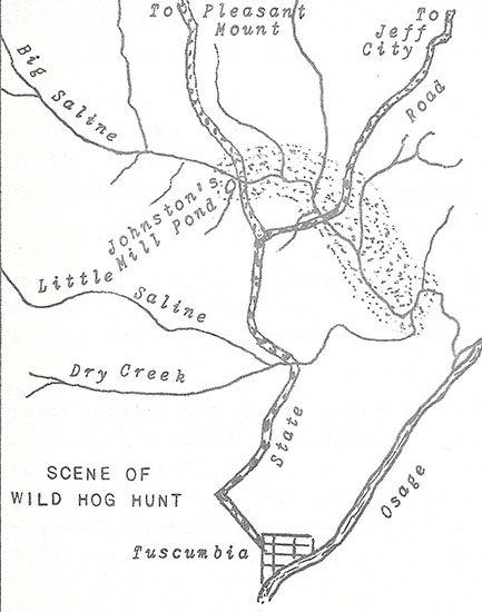
“We were in that great gang of wild hogs which run over even on the north side of the Saline creek, past Mr. Albertson’s,” George W. Johnston said. “There is a big wild boar in this gang of hogs,” he continued. “These animals are skittish even of our marked5 hogs running at large in the woods. The big boar gutted one of our dogs when it grabbed a running pig’s ear. He is dangerous; moves fast! We keep in two’s and three’s so a loaded piece6 is always near. Old Sandy Rip will weigh about 150 lbs.”
At the end of the stalk field, near the Saline creek, another hog was shot, and killed, and laid upon a log. George W. Johnston felled the hog at 50 yards. His brother, James, put a knife in its throat while it was still squealing rather severely, then he moved away rather rapidly to watch for the big boar, but the hawg’s squealing soon ceased.
Soon afterward, the wild boar led his long-nosed gang into a place of refuge, the hollows and hogbacks between the Big and Little Saline creeks, an almost impenetrable wilderness.
The next day, thirteen long-nosed, hazel-splitter, hogs hanging in the log smokehouses of a few pioneer families in Jim Henry township, were enveloped in gentle wisps of pungent hickory smoke, seasoning and flavoring the wild meat.
1. B.J. Baxter’s ear mark, “a smooth cross & over bit and under bit from each ear.” Marks and Brands, Book A, page 53
2. John Vaughan settled on the Saline creek in 1827
3. James Johnston served in the Mexican War, crossing the plains in 1846 from Ft. Leavenworth to Santa Fe, under General Kearney. Afterward, under Colonel Doniphan, he went to Monterey, and was at Mattamoras. He was discharged from the service, at New Orleans, in June, 1847. Later, during the Civil War he was Captain of Co. A, Parson’s Division, under General Sterling Price, fighting in the battles at Carthage and Wilson’s creek.
4. Johnston’s mill pond
5. Domestic hogs ran at large. Ownership was determined by marks upon an animal’s body. The ‘mark’ was recorded upon the book of Marks & Brands, at the Courthouse, in Tuscumbia
6. Gun
On April 11, 1856, John Thornsberry, Abraham Casey, Peter Casey, Francis Stewart, and Washington Casey were riding in company with Joseph M. Ulman, coming from Kinderhook’ country in the big wagon, to their homes in Glaze township.
“Near McCullough’s place,” Ulman said, “John McDowell was near the road, chopping wood.”
Abraham Casey said, “John Thornsberry crowed like a chicken twice, and John McDowell answered him likewise, flapping his arms. McDowell hollered he was Cock of the Walk!”
“John Thornsberry,” Washington Casey said, “in a loud tone of voice, informed McDowell, You cut your wood very fine! McDowell replied it was none of his damned business how he chopped wood. Thornsberry answered he would make it his business. McDowell told him to light out of the wagon.”
Thornsberry jumped out of the wagon on the side McDowell was on.” Abraham Casey continued, “and McDowell met Thornsberry, making a mark in the road with the toe of his boot, daring Thornsberry to cross it.”
“Thornsberry tippy toed over the mark,” Francis Stewart said, “and informed McDowell now I am across the mark why don’t you strike me, for it should not cost you anything? Then McDowell made towards Thornsberry, and he commenced giving back, until they got on the opposite side of the wagon. I heard McDowell say to Thornsberry don’t draw that knife.”
“Just then,” Peter Casey said, “I heard the sound of a lick, and upon looking around, saw Thornsberry in the act of falling, and I said to myself, knocked down with a rock.”
Francis Steward said, “I saw McDowell draw a rock out of his pocket. McDowell threw the rock at Thornsberry. It would have weighed a pound or more. They were about four feet apart. The rock knocked Thornsberry back, and he fell in his tracks. He began complaining of being very sick.
Words continued between the men in front of McCullough’s house, until the group with Ulman were scattered as John McDowell, Thomas Sparks, Lucinda McDowell, and Mary McCullough took after them with rocks and clubs in a manner calculated to do great bodily harm.
“As we drove away,” Joseph M. Ulman concluded, “John McDowell crowed like a chicken a number of times, and when I looked back, he was standing in the road flapping his arms.”
Hightower T. Hackney said, “In April, 1859, Green McGlothlin and myself swapped horses. He insured his mare to be a No. 1 plow nag, and any boy could work her. Then we went a mile or so from where we swapped to one Mr. Ware and borrowed his gear and went to the field where Ware had just been a plowing, and put the gears on the mare and hitched her to the plow, and Green McGlothlin could not plow himself.”
“Ware led the mare,” Hightower continued, “I told Green McGlothlin that she was no No. 1 plow nag, so I must have my own mare back. He then out walked me, pushing on to the fence where my mare was hitched, and jumping on her, rode her off. There I was, compelled to stay all night.”
“The next morning,” Hightower said, “I went to Esq. Legs to see if I could not apprehend him and get my mare. Legs looked at the law and said that I could not sue him only for $40 and my mare was worth double that. He then advised me to go to Green McGlothlin, and he would give me up my animal.”
“I went there,” Hackney continued, “but he had left home for he expected me. His wife told me that the 3 ½ dollar note I might have, but I never should have the mare. When night came he returned home. I told him I had come after my mare. He told me the mare I should not have. I told him that I would not go home until I got my mare, and he said, very well, I was welcome to stay if it was a month. He had plenty to eat, and good pasture, but I should not have my mare!”
In 1842, there was a big flare-up between neighbors in the Little Richwoods. In June, Thomas McCubbin, Sr., filed slanderous charges against his neighbor, Daniel Boone Etter, which landed Etter in jail at Tuscumbia.
On June 6, to obtain his freedom, Daniel petitioned the County Court for a writ of Habeas Corpus.
The next day, Abraham Castleman, deputy sheriff, appeared at the Courthouse with Daniel, and the Justices of the County Court proceeded to inquire into the cause of his restraint and confinement.
After sundry witnesses were examined by the Justices, Etter was set at liberty by the County Court.1
On August 2, 1842, Thomas McCubbin, Sr., informed the Judge of the Circuit Court, at Tuscumbia, that his neighbors, Samuel Etter, William Etter, Nathaniel Wirick, Ethaldred Wirick, Calaway Wirick, Robert Wirick, James Armstrong, and Daniel Etter having come to his place and approaching his person in a hostile manner, assaulted him, then further insulting and quarreling, even though he retreated, was pursued until again intruded upon, and knocked down several times!
He believed himself in danger of great bodily injury and personal harm for Daniel Etter and Calaway Wirick were threatening his life, having combined together for that purpose.
The Circuit Judge placed the men under heavy peace bonds, conditioned they remain on good behavior toward the citizens of Missouri, especially each other.
1. County Court Record Book A, page 139
The old log Courthouse presented many maintenance problems. Once the County Court ordered all of the trash and filth removed from under the building, then the house underpinned with logs or blocks, and sealed with stone to keep out the hogs.
In the coolness of wintry weather, one fireplace and a Franklin stove failed to maintain proper warmth inside of the Courthouse, so another fireplace was added, and when finished, Sheriff John H. Harrison was ordered by the County Court to sell the Franklin stove and pipe at public auction.1
In 1844, William P. Dixon, County Clerk, unable to endure the coolness of another winter in the Courthouse, built a Clerk’s Office, and when finished, moved the county’s records into it.
This Clerk’s Office, a frame building of plain construction, well-built, was situated on the Village Square where the present Courthouse now stands. Dixon was allowed $75 by the County Court from public funds for the erection of the Clerk’s Office.2
The following year the Courthouse was repaired, with the cracks in the building tightly sealed. The County Clerk returned to the Courthouse, and the Clerk’s Office was rented to Silas Capps, a term of six months for 62 ½ cents per month.3
In the Autumn of 1846, the County Clerk once again moved from the Courthouse into the Clerk’s Office. On February 3, 1847, “in consequence of the inclemency of the weather and the Court House being open,” Justices Robert E. Simpson, David Reed, and Thomas J. Marshall, “ordered that Court adjourn to the Clerk’s Office.”4
In 1856, the County Court, at its December Term, was petitioned by many citizens of Miller county to adopt such measures for the building of a new courthouse as would insure the speedy completion of the same. The County Court Justices, Johnson, Allen, and Jones agreed the petition “expedient and in the best interests of the county.”5
It was then ordered by the County Court that a sum of four thousand dollars of any money belonging to the county, and applicable to the purpose, be appropriated for the building of a new Courthouse for the County of Miller; and appointed Owen Riggs, Superintendent, for the erection of the same.
The Court having no suitable ground on which to build the Courthouse, ordered the “Superintendent to select a proper piece of ground for that purpose at the Seat of Justice, and purchase or receive the same by donation, and take good and sufficient deed or deeds therefor to the county; and that the Superintendent make report of his proceeding to the Miller County Court at its next sitting.”6
Plans were made for a courthouse to be erected “on the hill, or under the hill,” but this was settled by selecting the Village Square, so the County Court ordered “the Commissioner of the Seat of Justice sell at Public Auction to the highest bidder at the next sale of lots in Tuscumbia, and upon the same terms which he sells lots, the old county building known as the Old Clerk’s Office situated on the public square in said Town of Tuscumbia, reserving the ground upon which said building stands.”7
At the March Term, 1857, Superintendent Owen Riggs presented the County Court a plan of the new Courthouse. It would be located on land donated by Mr. Harrison. There would be a stone foundation. There would be two stories, and the building would be 56 feet in length by 40 feet in width. The height of the first story would be 14 feet, and the thickness of the walls, 18 inches. The height of the second story would be 12 feet, and the thickness of the walls, 13 inches. The building would be constructed of brick. The entrance door and all windows would have stone sills and caps. The whole building to be completed in as good and substantial style as the Jefferson City Female College.
Immediately the County Court ordered bids advertised for in the Weekly Jefferson Examiner; Weekly Jefferson Inquirer; and Weekly Missouri Republican.
On November 7, 1857, the contract for the building of the Courthouse was let to Robert McKim, for $6,000,8 with Robert Ainsworth associated in the work.
On May 5, 1858, Owen Riggs, behind with spring’ plowing, resigned as Superintendent, and the next day, the County Court appointed the County Clerk, E.B. Farley, to serve in his stead.9
Afterward, E.B. Farley, Superintendent of Construction, reported to the County Court that the mortar was lacking in lime, with many small pieces of brick going into the walls, the north wall especially. The front wall of good average work, the eastern wall exceedingly rough, having mortar joints too large, the western wall not so good. The bricks, having improper strength and durability, being quite brittle and very rough, were not merchantable, “many being put in contrary to my direction.”10
Farley was authorized to make alterations in the building of the Courthouse, and contractors Robert McKim and Robert Ainsworth agreed, “due to inferiority of materials, to paint with two good heavy coats of red paint, the whole exterior of the brick work of said building, the paint to be of the best material, put on in workmanlike manner, said brick work penciled. Further, first coat of plaster applied to interior of building to be of good lime and sand so as to form good cement, well put on, to twice the thickness of ordinary plaster. The above work to be done without any additional cost, and instead of two stairways there shall be only one.”11
On December 21, 1858, Superintendent Farley reported the building completed; having installed lightning rods and guttering for the Courthouse himself.
New Courthouse - Original Plan
In February, 1850, the County Court accepted the completed building. This done, the Court issued a unique order; “E.B. Farley is hereby appointed Commissioner to have charge of the new Court house in Tuscumbia, and he is authorized and directed to adopt such measures and regulations as he may deem necessary for the preservation of the building, subject to the approval of the Court. It is further ordered, Justices Allen and Jones concurring, and Justice Golden dissenting, that said Commissioner be and is hereby directed and required to prohibit and close the doors of the Court House against cotillion or dancing parties, preaching, singing, or public worship of any kind, tea parties, and all other parties or assemblies except for political purposes.12
Afterward, for approximately fifty years, this brick Courthouse served the needs of Miller county.
On December 1, 1858, the County Court ordered Evi B. Farley sell to the highest bidder at public auction the old Courthouse, and the lot upon which situated, in the Town of Tuscumbia.
1. County Court Record Book A, page 505
2. Ibid., page 204
3. Ibid., page 263
4. Ibid., page 299
5. December 17, 1856
6. County Court Record Book B, page 427
7. Ibid., page 452
8. Ibid., page 535
9. Ibid., pages 595, 597
10. Ibid., page 648
11. Ibid., page 651
12. County Court Record Book C, page 8
Steamboats first plied the Osage river in the late thirties. Probably the first year a steamboat used the river was in 1837. This was the same year an Act of the General Assembly established Miller County. During the last week of July, the steamboat North, out of St. Louis, ascended the Osage river into Miller County. Rapidly falling waters left the North on an island, high and dry, about thirty-five miles upstream from the Missouri river. North Saint Louis Island, above Curtman Shoals without any doubt was her namesake.
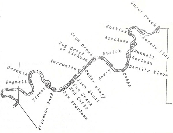
River Names at the Turn of the Century
Furnished by Dewey & Leonard Kallenbach
In the early Summer of 1838, the steamboat Adventure, navigated the Osage river a distance of almost 200 miles. In 1840, the Chouteau Belle hauled freight to Tuscumbia. The Leander, in 1841, carried approximately 200 tons of freight to Warsaw and Osceola.
This proved the Osage a navigable river. Immediately the settlers in the Osage valley made development of the river an issue of importance. Travel over-land by ox-wagon or horse drawn equipment, or upon the river by flat or keelboat, was slow, tedious, and costly.
In 1842, Captain Nansen Bennett, of Cote Sans Dessein, built the Maid of Osage for use on the Osage river. In 1844, the Maid of Osage, during one of the great floods on the Osage, made a trip to Papinsville, in Bates county, then steamed on to Harmony Mission and Sun’s Point. This same year the steamboats Agatha, Huntsville, and Warsaw entered the Osage river traffic.
Captain Thos. T. Dodd, of Jefferson City, who spent most of his adult life upon the Missouri and Osage rivers, often noted that, in 1841, when Bates county was organized, the County Seat was fixed at Butler, with Papinsville the nearest town on the Osage river. The Bates County Court entered of record, an order, offering to anyone bringing a steamboat first to Papinsville , a reward of ten of the best lots in the town of Butler, plus one hundred sixty acres of land within one and one-half miles of the town. Captain Nansen Bennett, with the Maid of Osage, undertook the feat, and accomplished it.
On February 11, 1830, the General Assembly of Missouri created a State Board of Internal Improvements. The main duty of this board was to have the principle rivers of Missouri surveyed and a report issued on what could be done to make them into navigable streams. On August 2, 1840, a survey of the Osage river was completed, with the shoals and rapids enumerated from Osceola to the Missouri river. On December 20, 1840, the Board of Internal Improvements issued its first, and last, report.
Immediately, merchants along the Osage actively petitioned the General Assembly and the Congress of the United States to aid in the development of the river into a navigable waterway. They wanted a dependable water-course for steamboats. The prosperity and development of South-Central and the South-Western regions of Missouri depended upon it.
A Memorial of the General Assembly to the Congress, follows:
A MEMORIAL TO CONGRESS ASKING THE DONATION OF LANDS FOR THE IMPROVEMENT OF THE OSAGE RIVER
To the Honorable, the Congress of the United States.
The memorial of the General Assembly of the State of Missouri, respectfully sheweth, that the Osage river is of great importance, both to the United States and to the State of Missouri.
It takes its rise in the Indian country west of the State of Missouri, and after running through a part of that country, and upwards of three hundred and twenty miles through the State of Missouri, enters the Missouri river one hundred and twenty miles above its mouth. It has been examined and surveyed by a competent engineer, from its mouth to Osceola, a distance of two hundred and thirty miles. In that whole distance, there was found no rock to injure its navigation, excepting a few loose rocks in a space of only two hundred yards in length, where the fall was only one foot and a-half, and which rocks are easily removed.
The banks being permanent, but few objections to its navigation are found, these few consist of bars at low water, and logs, and overhanging trees.
It is a large and beautiful river, nearly equal to the Ohio immediately below Pittsburg; and affords, at a very low stage of water, by actual measurement, 131,000 cubic feet of water per minute. It is also unobstructed by ice, six weeks or two months in the year, when the Missouri and upper Mississippi rivers are greatly obstructed. The whole expense of improving it, from its mouth to Osceola, was estimated by the engineer at two hundred and four thousand dollars. From the last mentioned place to Fort Scott, situated upon the river in Indian country, and the distance is by the river about eighty or ninety miles, by land about sixty miles.
The river from Osceola to Fort Scott, is easily made navigable for steamboats, there being no permanent or serious obstructions to be overcome. The tract of country lying within the valley of the Osage river, and within the State of Missouri, was estimated by the chief engineer of the State to be eighteen thousand square miles, over one-fourth part of the State, this is besides a vast extent of Indian country lying west of the State on the Osage river and its tributaries, all of which would be benefitted to an incalculable degree, by improving the navigation of that river.
Your memorialist entertains the opinion that the United States are under obligations, arising from duty and interest, to assist in the improvement of the navigation of this river. The government of the United States has collected on the frontiers of this State, herds (hords) of restless and dangerous Indians, the warriors of which, according to an estimate of the commissioner of Indian affairs, amount to twenty thousand; these warriors, united to the warriors of other tribes, amount, according to the same estimate, to sixty-six thousand. The United States are bound to defend the people of this State against all interruptions from these tribes, and are also bound by express treaty stipulations, to protect the emigrant Indians in their new residence, against all interruptions and disturbances from any other tribes or nations of Indians, or from any other person or persons whatsoever. This defence cannot, either with justice or sound policy, be left to chance; not only means of defence, but certain and efficient means, ought to be provided; and no means can or will be more certain and efficient, than the improvement of the navigation of this great river, leading into the Indian country, by which means steamboats with troops, munitions of war, and provisions, can be taken to the scene of danger at almost any season of the year, excepting during the depths of winter.
The United States are owners of great quantities of public lands, in the Valley of the Osage river; but little of the public lands, compared to the whole, being yet disposed of; these lands will be greatly enhanced in value by the improvement of the river, and the United States ought, therefore, on principles of equity and justice, to aid in its improvement.
The United States have a military post, Fort Scott, in the Indian country, on this river; the expenses of supplying this post, even in time of peace, would be greatly diminished by improving the navigation of this river. If war with the Indians should occur, the river would be the principal means of access to the Indian country west of this State, and the saving in the expense of transportation would be immense.
The Congress of the United States, in the act to authorize the people of the territory of Missouri to form a Constitution and State Government, &c., approved March sixth, eighteen hundred and twenty, provided that the river Mississippi, and the navigable rivers and waters leading into the same, shall be common highways, and forever free, as well to the inhabitants of said State as to other citizens of the United States, without any tax, duty, impost, or toll therefor, imposed by the said State. The Osage is presumed to be one of the rivers included within the provisions of this act, and if so, and the State should improve its navigation, it could lay no tolls to pay the interest on the expenditures, or keep the improvement in repair.
The state is then, in regard to this river, by the provisions of said act, deprived of the right and privilege of most of the other States of this Union, of improving the navigation of this river, and laying tolls to sustain the expense.
Under these circumstances, your memorialist reiterates the opinion, that the United States are bound to aid in the improvement of the navigation of the Osage river. This indeed was expressly recommended to Congress in Eighteen hundred thirty-seven, by the United States, chief engineer, as necessary and proper, to the defence of the western frontier.
But your memorialist does not ask Congress to bear all the expense of this improvement, although your memorialist believes it might do so with more grace than has been shown in regard to improvements asked for by other States, many of which Congress has assented to. Or does your memorialist ask Congress to grant money in aid of this improvement, but to grant public lands, either in alternate sections or otherwise, as Congress may deem advisable. For these cases, less meritorious examples could be shown, at nearly every session of Congress, and for the benefit of nearly every State and territory in which there were public lands, and embracing a great number of cases in the same State or territory. Missouri has never, either as a Territory or State, received any grant of lands or money to aid in making any road, or improving any particular river. The United States have even withheld from this State the two per cent fund, which was to be employed in making roads, or a road leading to the State. And yet, although twenty-seven years have expired, no road is made by Congress leading to this State. All the improvements within this State, which, although not including any one great work, have yet been numerous and expensive, have been made exclusively by the State and the people of the State, whilst the United States received in the enhanced value of the public lands, and is yet receiving, great advantages from these improvements.
Your memorialist, therefore, respectfully asks Congress for a grant of public lands, in alternate sections or otherwise, to aid in the improvement of the Osage river.
Resolved, That the Secretary of State be required to furnish each of the Senators and Representatives in the Congress of the United States, from this State, with a copy of the above memorial.
Approved February 15, 1847.
Steamboats on the Osage river carried goods to the main ports of Lisletown, Tuscumbia, Linn Creek, Warsaw, Osceola, Taborville, and Papinsville.
Lisletown was where Captain William L. Huber lived with his family in a castle on the river bluff, at the mouth of the Big Maries. The river bluffs up and down the river from Lisletown presented a view unsurpassed in beauty and scenery. Without any doubt, the Lisletown Ferry, in this era, was the most important conveyance on the Osage river. The road from Saint Louis to Jefferson City, and places West, crossed at this point. An Act of the General Assembly, approved February 15, 1847, established a State Road from Lisletown to near Judge German’s residence in Morgan county. From the Lisletown Ferry this road passed through Spring Garden and Pleasant Mount into Morgan county.
Tuscumbia was where J.P. and J.B. Harrison, two bachelor brothers, conducted a large mercantile business, followed by Daniel Cummings, and others. C.P. Davidson, in 1837, was Tuscumbia’s first ferryman. Tuscumbia, in the earlier days, was one of the major river ports for the Southwest Missouri and North Arkansas trade.
Joseph Washington McClurg, in 1852, established a whole-sale and retail mercantile business at Linn Creek. Prior to 1852, Linn Creek was one of the greater river ports, but McClurg soon made it even more important by entering into the steamboat traffic himself with the Emma, Alliance, Mary C. and Linn Creek. Other Boats, chartered by him, moved goods down the Ohio river to his wholesale business at Linn Creek. In 1858, thirteen steamboats arrived at the Linn Creek landing from St. Louis, with goods valued at well over eight thousand dollars.
Colonel Bledsoe, in 1891, established a ferry and opened a store in the midst of the hunting grounds of the powerful Osage Indians. First known as Bledsoe’s Ferry, eventually the place evolved into Warsaw, becoming a river port of importance. Later the Vaughans, opening stores at Warsaw and Osceola, owned four steamboats, the Belfast, Navigator, Regulator, and Umpire. These boats were used in the carrying of freight to and from their stores. In 1854, the Port of Warsaw shipped 144 bales of deer skins, 2,230 furs, 33 barrels of beeswax, 11,994 pieces of bacon, and much wheat, corn, and whiskey. From St. Louis the Port of Warsaw received 8,000 tons of freight. James F. Atkisson was another prominent merchant of Warsaw, in this era.
In 1841, the State of Missouri received from the Government of the United States one-half million acres of land, the proceeds from the sale of this donation limited to internal improvement. The General Assembly, by an Act approved on March 27, 1845, distributed the proceeds from the sale of this land equally among the several counties. Immediately the citizens demanded this money used in the development of Missouri’s rivers.
On February 15, 1847, an Osage River Association was formed and incorporated, for the purpose of making the river more navigable. Counties were authorized by the General Assembly to have their Internal Improvement funds, Road and Canal funds, and other monies placed in this association.1
In 1848, Daniel Cummings presented a petition to the Miller County Court, signed by a majority of the taxable inhabitants in the County, requesting the county’s distributive share of the half-million acres of land donated by the United States to Missouri for internal improvement, to be invested in the Osage River Association. The Court agreed, and on May 2, 1848, appointed John B. Harrison, of Tuscumbia, a Director of the Osage River Association. Harrison was re-appointed Director, on May 9, 1849.2
This Association divided the river from St. Clair to its mouth into five districts. Tuscumbia to the mouth of the river formed the first district. From Erie, the county seat of Camden county, to Tuscumbia, formed the second district. Work commenced, with the first district, in 1848, having used over $800, the second district over $1,000, on river improvements.
Miller County contributed considerable money, but only a few counties joining the association, destroyed its effectiveness. Although considerable work was done of the channel of the Osage with available funds, the efforts of the association merely indicated what could be done with adequate money.
In November, 1852, the County Court ordered Miller County withdrawn from “The Osage River Association Company, for said company is not now nor has it been organized for some time, and has entirely failed to accomplish the object for which it was established or created.3
In August, 1853, the Miller County Court ordered that, a sum of two hundred dollars be appropriated out of the internal improvement fund for the improvement of the Osage river at Berry’s Shoals and appointed Emly Golden, commissioner, to superintend the work.4
In the early fifties the demand for an improvement in river transportation grew so strong the General Assembly passed an Act, approved on February 14, 1855, which provided fifty thousand dollars for the clearing of impediments to navigation in the Osage river from Osceola to its mouth.5
Sydney R. Roberts, of Linn Creek, James Atkisson, of Warsaw, and William L. Vaughan, of Osceola, were appointed commissioners to carry into effect the provisions of this act.
A majority of the counties forming the old Osage river Association were required to assign to the State of Missouri, all of the rights acquired by them under an act to provide ways and means to improve the navigation of the Osage river, approved February 15, 1847, and this was done by the Miller County Court on June 19, 1855.6
Roberts, Atkisson, and Vaughan, meeting on August 9, 1855, organized as a board, immediately dividing the river into three districts, -the first, from the mouth of the Osage to the mouth of the Niangua river; the second, from the Niangua river to Warsaw the third, from Warsaw to Osceola.
Under their supervision, the channel of the Osage river was much improved. This was accomplished by building tree and rock dams.
Trees were laid with the butt ends down river, then covered with stones. Dams four to eight feet in width, and two or more feet in height above the average low water mark were erected. Built at an angle across the river these dams backed the water over the shoals and made the channel narrower near one of the river’s banks.
Roberts, Atkisson, and Vaughan, in a little over one year, expended the entire appropriation of fifty thousand dollars. William L. Vaughan, Chairman of the Board, received one dollar less than the other two commissioners, as compensation for services. On February 8, 1861, Chairman Vaughan reported more steamboats using the Osage river than in the past due to the Board’s effort toward making the river more navigable.
The Emma, Captain J.W. McClurg, with a carrying capacity of almost 85 tons, was used in this work, pulling snags and towing barges filled with rock to the numerous cross-dams erected below the shoals.
Captain Joseph Washington McClurg, an outstanding pioneer in early steamboating upon the Osage river, was born February 22, 1818, near present day Lebanon, Missouri, then in Saint Louis county. Orphaned at an early age, he was reared by relatives. When a young man he taught school for two years. Later he studied law, and was admitted to the bar. At Columbia, Texas, in 1840, he served as Circuit Clerk. From 1841 to ’44 he was a Deputy Sheriff in St. Louis County, Missouri. In 1843, he opened a store at Hazelwood, but six years later, he joined the California Goldrush. Back in Missouri in 1852, he established a wholesale and retail mercantile business at Linn Creek, and immediately engaged in freighting upon the Osage river.
Elected to Congress in 1862, again in 1864, and for a third term in 1866; he resigned to become Missouri’s nineteenth governor in January, 1868.
Governor McClurg was a man of short stature. His manner of dress included a longtail coat and a stovepipe hat. He was deeply religious. He tied-up his boats where ever located from midnight on Saturday until after midnight on Sunday. On his run from Osage City to Linn Creek he usually stood, like a statue, somewhere upon the decks of his steamer. Always, the stovepipe hat was upon his head. It was kindly said of him that, as his boat churned by in a fast run, “the tails of his coat flapped in the wind, and his flowing full beard streamed from his chin.”
The steamboat Wave was very active in the early Osage river trade. From the Osage river she called at the Port of St. Louis in the early 1840’s; and in March, 1850, arrived at St. Louis with a cargo including, among other items, over three hundred venison hams. In the Autumn of 1849 the Wave sank a short distance above Warsaw. McClurg’s steamboat, the Alliance sank in the Osage river with a cargo aboard valued at over $40,000 on September 18, 1855. Much later, the Emma, another of McClurg’s steamboats, sank to her watery grave in the Missouri river.
Steamboat disasters on Missouri’s rivers created a demand by the people that the government do something for the protection of life and property. It was well put by one person who testified, “If a man gets his arm broken by being overturned in a stage-coach, he comes upon the proprietors for damages. So it should be in steamboats. Captains and owners should be held responsible for every accident. No boat should be allowed to take passengers which is not secured, in every way possible, from fire and explosion, and the safety of passengers secured by providing means of escape. The full value of merchandise and freight aboard should be guaranteed against loss by Captains and Owners.”
From 1850 to 1860, well over one hundred steamboats called in the Port of St. Louis from the Osage river. In May, 1856, the Thomas E. Tutt, a big side-wheel packet, made the trip from Linn Creek to the confluence of the Missouri and Osage rivers in ten hours. In June, 1861, while the Osage was on a rise and steady, the Financier made a run from Warsaw to St. Louis in 22 hours, almost unbelievable! According to Captain Thos. T. Dodd, the largest freighter ever to ascend the Osage, was an Ohio river boat, the Last Chance. With the river in a high rise, the Last Chance carried 8000 barrels of salt, and other freight, to Osceola. This may have been the largest cargo ever carried up the river.
Some of the steamboats on the Osage river before the Civil War were the North, Maid of Osage, Chouteau Belle, Wave, Little Jack, Adventure, Leander, Agatha, Huntsville, Warsaw, Emma, Alliance, Reliance, Linn Creek, Belfast, Navigator, Regulator, Umpire, Thomas E. Tutt, Last Chance, Otter, Cora, Lightfoot, Haydee, Eliza Stewart, Martha, Daniel Hillman, Enterprise, Financier, Allegheny Mail, Lake of the woods, Mary Blane, Pocahontas, St. Ange, Wenona, El Paso, St. Francis, Milburn, Excel, Mary C., E.A. Ogden, Gossamer, William Phillips, Castle Garden, Laclede, Fire Canoe, Chippewa, Mansfield, Saracen, Sam Kirkman, York State, Medora, Lake City, T.L. Crawford, Courier, Dew Drop, Conewago, Cedar Rapids, Forest Queen, Colonna, and others.
The upstream traffic consisted mainly of salt, iron, liquors, and groceries for the many merchants. The cargoes going downstream to the St. Louis Market were venison, bacon slabs from acorn-fed Ozark hogs, furs, skins, corn, and wheat. Considerable quantities of corn whiskey were shipped to the St. Louis and Southern markets. Other goods included cattle, dried beef, chickens, hams, eggs, flour, lead, zinc, barytes, tobacco, potatoes, staves, molasses, tallow, and soap.
1. Laws of Missouri, 1847, pages 217 to 223, inc.
2. County Court Record Book A, pages 366, 418
3. County Court Record Book B, page 86
4. Ibid., page 160
5. Laws of Missouri, 1854, pages 179, 180, 181
6. County Court Record Book B, pages 298, 299
James Atkisson, merchant at Warsaw, early in the year of 1857, entered into a contract, while shopping in St. Louis, with William Parkinson, Captain, Master, and Agent of the Castle Garden, to freight merchandise purchased by him to the Warsaw Landing on the Osage river. It was agreed the Castle Garden would tow one of Atkisson’s flatboats, lying at the mouth of the Osage river, with the privilege of taking freight upon the flat while towing it to Warsaw.
On March 7, 1857, the steamboat Castle Garden proceeded from the Port of St. Louis for the Port of Warsaw. Upon arriving at the mouth of the Osage river, Parkinson, at Boomer’s Landing and Warehouse, placed upon Atkisson’s flat, 30,000 feet of pine lumber and flooring, and 100 barrels of whiskey. With the river in a low stage, the steamboat Castle Garden steamed to Tuscumbia, delivering freight, then dropping down the river, tied-up at Boomer’s Landing from about April 1, until June 1st.
Parkinson, returning to St. Louis, left the flatboat with the lumber and whiskey on board, in charge of James S. Dodd. While in Dodd’s and a Mr. Harper’s care, the flatboat twice sank, causing 6,000 feet of lumber to float away, the rest mildewing from water filling the flat. The whiskey barrels, exposed to all kinds of weather and sunshine, commenced leaking, while some of the barrels were tapped with gimlets, and much whiskey lost.
In the last week of April, 1857, with a rise coming in the river, James Atkisson, anxious to get his merchandise, commenced making preparations for moving it to Warsaw.
Captain Isham Joplin said, “I went to the mouth of the Osage, June 1, 1857, to bring up a flatboat loaded with pine lumber and whiskey for Atkisson’s at Warsaw. I took eight hands and a cook with me. I went down in a wagon with the nine men to the mouth of the Osage, James S. Dodd was in possession of the flat. I asked to go aboard the flatboat upon arrival, and put her in order, but Dodd would not let me. He would not let me have it without an order from the Captain of the Steamer Castle Garden, even though I had Atkisson’s papers. He kept me waiting three or four days, myself and the nine men with me paying our own expenses.”
“Before I could examine the merchandise,” Captain Joplin continued, “I was advised by McKernon that I must sign a receipt that the whiskey and lumber received were in good order. I pointed out we should examine the merchandise, but he informed me I must sign the receipt to get possession of the boat and contents. After I was assured by Mr. Dodd if anything was wrong the Captain of the Castle Garden would make it all right. I signed the receipt and went aboard.”
“I found whiskey and lumber on the flatboat,” Captain Joplin said, “a large amount of lumber, and I think 99 barrels of whiskey. The lumber was wet and mildewed and black, the tongues and grooves split off the exposed boards. The lumber was stowed all over the boat, even forward of the cook house. The whiskey was stored so as to be exposed to the sun, wind and rain all the time. Many of the hoops were off the barrels, in a leaky condition. Some were full, some partially so. There was one barrel that had 16 or 17 gimlet holes in it. McKernon knocked the bung out of one of the barrels, and when turned on its head, the whiskey came up nearly to the bung hole, so had about 20 gallons in it. The barrels were lying in rows with plank over them, the heads exposed to the sun. Water was standing in the flat about three or four inches over floor timbers. I called Mr. Dodd’s attention to the condition of the boat and told him she would sink, and he laughed and said she had endeavored to do so. I found lumber on the shore below the boat similar or exactly like the lumber on the boat, and on the same side of the river the boat was lying.”
James S. Dodd said, “I was on board the Castle Garden when she left to go up the Osage, and the Captain got me to take charge of the flatboat, lumber, and whiskey, which all looked to be in good order, except one barrel which had some of the hoops off of it, and I upheaded it to keep the whiskey in. I delivered the whole to Captain Joplin. He brought a letter from Atkisson to McKernan to assist him in receiving the boat and freight, and be careful how it was received. Joplin gave me the receipt, and I did not see it until it was handed to me by McKernon, who asked me if that would do, and I told him it would. I was absent from the boat after I took charge of her. I left a better man than I am in charge of her, Mr. Harper did not have a gimlet as far as I know.”
With the river on a head rise, action commenced. J.H. Wear said, “I am clerk of the Mary C. I started down on the 4th of June to meet her, and did meet her at Bois Brula Shoal, then she broke her shaft at White Oak on Sunday morning. I started on to the mouth of the Osage, and reached there on Sunday night. Found the Castle Garden there. I was there until Monday afternoon, and saw Captain William Riseley and his crew get off the cars and go down to the boat.”
George Williams said, “I was at the mouth of the Osage at the time the Castle Garden was there. She was laid up there from about the 1st of April to the 1st of June. I started up on the Mary C. on Saturday before the Castle Garden. We got up about 50 miles and broke a shaft. There was a 7 or 8 foot rise at or about this time. We started as soon as we found the rise was coming. When we left, the pilot was not on the Castle Garden. We met him about 15 miles up the river going down. Mr. Smoot was the pilot who brought her up.”
William Smoot said, “I am a pilot on the Osage river, have been about fifteen years. I was employed in the month of June, 1857, to bring the Castle Garden up the Osage river. I left Warsaw on the 4th day of June, Thursday, in a skiff to go to the Castle Garden. The river was rising, had raised about three feet, and was still rising. I got to the Castle Garden on Saturday evening after leaving Warsaw. I met the steamboat Mary C. at Brice’s just below Boomer’s Mill, loading. I reported myself on board the Castle Garden on Saturday evening about four o’clock p.m. I found James Dodd in charge of the steamboat. Dodd said they had gone after a crew, and engineers. I staid aboard the boat. The engineers came aboard on Sunday.”
“On Monday, Captain William Riseley and a chambermaid came aboard, and Captain Riseley took charge of the boat” pilot Smoot continued. “The captain asked me how much water was in the river? I told him six feet, and rising. The Captain asked me if we could take the flat boat? I told him no, the river was too low to tow it. Then they run the flatboat above the bridge, on Sunday. They took some whiskey from the flatboat on board the steam boat, but I don’t know how much.”
“Then we left the flatboat, and went up river without detention to Dixon’s shoals,” Smoot said, “where we grounded about two hours. The reason of this detention was the capstan was encumbered with salt and could not be worked, and continued to be so until we got within six miles of Linn Creek. We proceeded from Dixon’s Shoals meeting a rise with from five and a half to six feet. On the shoals passed the Mary C. on Tuesday morning at Devil’s Elbow. The Mary C. had a shaft broke. We put in at Tuscumbia, and went on up to the mouth of the Little Gravois, and lay up until Wednesday morning. The next morning we got to the head of the schute and could not stern it. We put out a line and pulled over by hand. About eight feet of water was in the channel. We were detained a right smart while here. Then we went on to the upper Howser shoal, and put out a line, and pulled through by hand, and was detained some four or five hours, here, there was ten feet of water, but swift. Then we went on to the foot of the Salt shoal that night and lay there until Thursday morning. We made an effort to stern it over night. On Thursday morning we put out a line, pulled up, steamed through, and went on. When we got to Loly’s shoal about six miles below Linn Creek, we couldn’t stern it, either”
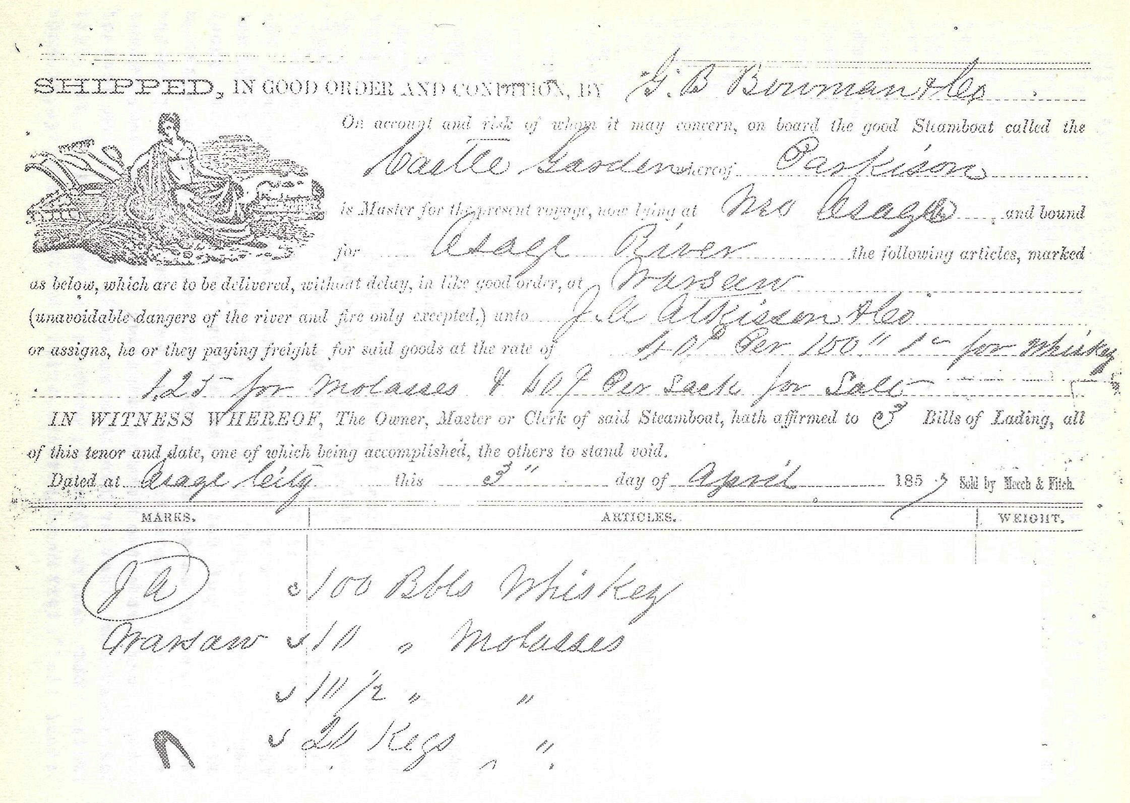
A Portion of one Bill of Lading
Click image for larger view
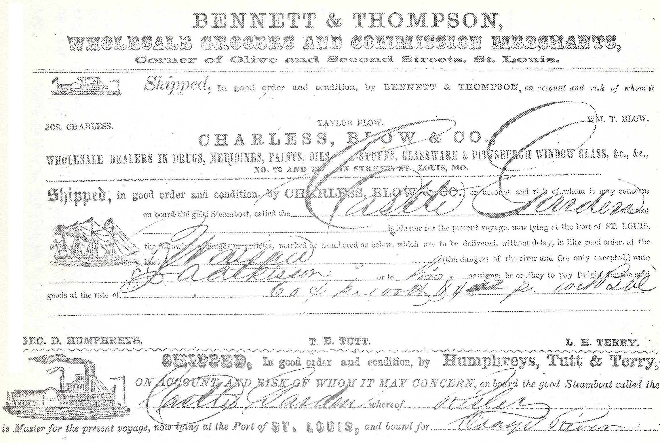
Merchants Doing Business at the Port of St. Louis
Click image for larger view
“Here, we cleared the capstan,” pilot Smoot continued, “detained in clearing up the capstan and putting out the line three or four hours. After the capstan was cleared, and the line fast, we started out, but the line parted. It was an old line, and much too short. Then we went back, got up the line and when bent over and the line fast again, dropped into the current, very gently, and got over directly. The reason for this the capstan was so encumbered it could not be worked properly, and we could not have got over without it. Ordinarily the Castle Garden was a good sterning boat, but she was improperly loaded.”
“At this point,” William Smoot said, “the river had commenced falling, had fallen four or five inches. We got to the foot of Linn Creek shoal that evening about two o’clock p.m. There was about six feet of water in the channel. There was plenty of water for the Castle Garden to go over the shoal, but she was not provided with the necessary and suitable rig-ring such as boats generally have. The line was not long enough to tie far enough ahead. It was an old one. They tried it on all the falls. I told Captain Riseley he must tie his line farther ahead, but the Captain said that was all the line he had. I told him then to put out the spar, and wind on the head line, but he did not do it. Finally he told me to drop her out and put in at the landing below the shoal, and I did it. This was on Thursday. We had been trying to get over until about two hours by the sun.”
“As soon as we landed,” Smoot continued, “Captain Burgess came through with his rafts. They were large rafts, long and large logs. The same day, Friday, the Alliance with a flat boat in tow came up and went through the shoals. She went through without any trouble, after putting out her line. Probably the Linn Creek shoal is the worst to get over, for even when the water is deep enough, it is still very, very swift.”
Pilot Smoot said, “On Friday morning, Captain Riseley hired a flatboat, and commenced boating the freight up to Linn Creek. From forty to sixty tons were delivered on Friday. That lightened up the steamboat five or six inches. I went voluntarily and asked Colonel Roberts for his warp. He said tell Riseley he was welcome to it to come through that shoal and clear through up to Warsaw, for he knew it was James Atkisson’s freight, and for his accommodation, he was welcome to it. When I returned, and told Captain Riseley, he just walked off, and made no reply, nor did he appear to thank me for my services in this matter. We could have gone through and cleared the shoals and went on to Warsaw if Captain Riseley had of used the warp Colonel Roberts offered to loan him. I think the officers of the Castle Garden did not understand boating on the Osage river. Captain Murphy, with three or four niggers, would have done more good than that whole crew of twenty-five or more men, but they did the best they could working by hand.”
Saturday evening, June 13, 1857, Captain William Riseley and Pilot William Smoot journeyed into Linn Creek, staying all night in a boarding-house. While thus put-up in comfort, the crew on the Castle Garden mutinied! There was a big row amongst the 25 or more deck hands, and eight men were killed. This was too much for Captain Riseley! He informed Pilot Smoot to engage a crew of hands, and when the river rose, come and take up the boat.
William Smoot said, “The steamboat Laclede came up on Sunday about noon. I went aboard her at the foot of the shoal, and at the request of the pilot, I held her, whilst he went and got Roberts’ warp. He then went through. The river had fallen about eight inches, and the Laclede is a larger boat than the Castle Garden.”
“I left the Castle Garden on Sunday,” Smoot said. “I walked home (Warsaw) from Linn Creek, notifying hands as I came up. I got home on Thursday, with four or five feet of water still in the river. When I got home I was employed by James Atkisson to go and bring up the Castle Garden. He told me to take the stage-coach, as that was the quickest way, but when I got to the stage office, the stage was full and they would not take me because there was no room for me. Since Atkisson manifested an anxiety for me to get off so as to enable the boat to get up so that he might get his freight as quickly as possible, I got a skift, employed hands to assist and row the skift, and made the best possible haste. I ran all day and all night. When I got to the Castle Garden, the merchandise on her had been taken to Linn Creek.”
Colonel S.R. Roberts said, “I made a contract with the Castle Garden a short time after her arrival at Linn Creek shoal to bring up the merchandise on her with our flatboat to Linn Creek. There was at that time, I think, about six feet of water on the shoal, but I didn’t measure it. Mr. Lisle, the Clerk, was in charge of the boat at that time. The first flat boat load I brought off was consigned to McClurg and Co., the rest to Atkisson’s at Warsaw.”
Later, McClurg and Co. purchased Atkisson’s consignment, which consisted of: 20 bbls molasses; 10 ½ bbls molasses 20 kegs molasses; 103 kegs nails; 1 keg shot; 5 kegs S.C. Soda; 40 sacks coffee; 6 bbls tar; 5 boxes star candles; 10 ½ boxes star candles; 4 boxes soap; 23 bags cotten yarn; 1 bbl golden syrup; 1 ball batting; 16 hhds sugar; 601 sacks of salt; 1 bbl tar in bad order; 23 boxes candy; 36 plows; 2 boxes scales; 8 prairie plows; 2 crates enamel ware; 10 boxes pint flasks; 5 boxes quart flasks; 8 boxes glassware; 2 casks enamel ware; 11 boxes smoking tobacco; 1 crate enamelware; 20 bags Rio Coffee; 1 cask rice; 4 bbl copperas; 2 bbl alum; 5 pkgs, 11 curls rope; 1 box sardines; 5 bbls mackerel; 1 bbl lard; 1 bbl machine; 1 can neatsfoot oil; 6 doz. Demijohns; 20 half boxes glass 8x10; 10 half boxes glass 12x12; 150 bbls whiskey; 5 bbls rye whiskey; 5 bbls brandy; 1 bbl gin; 10 bbls bourbon whiskey; 4 bbls malago wine; 1 bbl rum; 1 bag pepper; 2 doz. 10 gal. kegs; 2 doz. 3 gal kegs; 3 doz. Red C. pails; 5 3 ¼ tubs; 1 pkg toy pails; and miscellaneous.
The freight for Atkisson’s aboard the Castle Garden weighed approximately 72 tons.
Daniel Melton said, “I live about 17 miles above Warsaw. I commenced rafting about the 9th of June, with a rise in the river. I brought my rafts to Warsaw without any trouble.”
“I was on a raft drawing about three feet,” Henry Cable said, “On the 14th of June, at the time I passed down, the Castle Garden was lying at the foot of Linn Creek shoal. The channel of the river at that time was from five to six feet. I measured the shallowest shoals I passed over. My raft was more than 150 feet long.”
Captain Burgess said, “I was at the Linn Creek shoal the day the Castle Garden came up. There was six feet of water on the shoal. If I am not mistaken the Captain told me he was drawing four feet, six inches, and if that was so, the Castle Garden could have passed over it. I have been on the river since 1839. I passed over the shoal with a raft drawing over four feet, and did not touch. I measured at the bar above Mrs. Crain’s, and it was five feet, and when that is the case there is six feet of water in Linn Creek shoal.”
Atkisson’s flatboat, with Captain Isham Joplin, and his men, in charge, was taken in tow above the bridge by the steamboat Laclede, and moved up-river. George Williams, on the Mary C., lying at Devil’s Elbow with a broken shaft, said, “When they passed us by, I saw the whiskey on the flat, and it was covered with plank.”
Captain Joplin said, “One third of the whiskey on board was leaking, we had to get them on their heads to keep the whiskey in. Some of them were half full, and some of them lighter. The plank was more than half mildewed, don’t know how much there was on the boat, did not measure it. We left at Tuscumbia, 110 bundles of flooring plank, and some rough plank. I had the flat boat taken up the river about 19 or 20 miles above Tuscumbia, and there left it in the charge of a Mr. Jenkins, and went on to Warsaw. I was gone about 18 days on the trip, and the cost of the trip for hands and everything was $282.00.”
“We left the flatboat at Russell’s shoals, 19 or 20 miles above Tuscumbia,” Sanford Brown continued. “A man by the name of Jenkins was placed in charge and possession of her. There was at that time 90 to 100 barrels, or pieces of barrels, of whiskey on board of her. Don’t know how much plank was on board, but we used some of the plank for damming the water on the shoals as we came up for the purpose of enabling the boat to get up. We used from fourteen to twenty pieces of the longest and broadest we could find, and we used them all the way up. Atkisson sent Mr. Shockley down to cooper up the barrels that needed it, and to the best of my knowledge there were from 8 to 12 empty barrels, which had leaked out.”
“I came up the Osage river on the Laclede,” Charles Smith said, “and at Linn Creek found the Castle Garden, which was the 14th of June. We came over the shoal with some difficulty on account of the shortness of our cable.”
“I went down the river to meet the Mary C.,” John B. Porth said. I came up on the Alliance. When we got to Linn Creek shoal the Castle Garden was there. The Alliance went through. The river had been 12 to 15 inches higher before we reached Linn Creek Shoal. There was 5 or more feet of water, with the river falling.”
William E. Tutt said, “I went to Russell’s Shoals where the flatboat was lying 19 or 20 miles above Tuscumbia, to deliver for Mr. Atkisson a lot of whiskey he had sold off of said boat to Smith and Vernon. We emptied what was in 11 bbls into others which were not full, making 78 full barrels. We left nine barrels containing some whiskey in them aboard the boat. A barrel generally contains 40 gallons. Smith and Vernon gave 35¢ per gallon for what they bought. There were 600 rough boards or planks on board, and 440 bundles of flooring. The amount put off was 66 rough plank, 136 bundles of flooring, and 162 flooring plank loose. This lumber was put off the boat before Captain Burgess brought her to Warsaw.”
Mr. Parish, a carpenter by trade, stated the flooring was the kind used in the best of houses. “I came upon the flat to Russell’s Shoal from the mouth, and at that place it was left in charge of a Mr. Jenkins,” he said. “I heard Dodd say he had used some of the whiskey, and we used some out of the barrels as we came up. The lumber on the boat was not very saleable after getting wet. The tongues and grooves were splitting off, and about one-half the plank was mildewed.” He concluded.
Captain Burgess, sent by Atkisson, in July, to bring up the flatboat, stated “I saw her the first time about 19 miles above Tuscumbia. The plank was scattered over the top of the whole boat, and in very bad condition. The top plank was split up, and was dried by the sun, the balance being all wet but in taking out the lumber, I found it considerably mildewed. I landed at Mrs. Crains, about 40 miles above Russell’s Shoal, where I complained that the boat was very heavy.”
John Lisle, Clerk of the Castle Garden, “was there on shore,” Captain Burgess said, “and I informed him as to the condition of the boat.” Lisle observed, “it was no wonder, that the damned old bitch sunk twice for me at the mouth!! “Sunk?” Says I. “Yes,” he said, ”she sunk over the gunwale, and the plank floated the boat, and the whiskey which was on top of the plank held it from floating off.”
Cost of freight from the Port of St. Louis to Linn Creek, by steamboat, averaged 50¢ per hundred pounds. Freight for salt averaged about 30¢ per sack, with barrel freight from $1.50 to $1.75 per barrel. Freight to Warsaw averaged about one-third more.
With a normal stage of water in the river, towing a flatboat upstream was a difficult matter. Atkisson’s flat, with 30 to 50 tons of freight on board, towed handily, but thirty thousand feet of lumber, and 100 barrels of whiskey, sunk her lower than normal water line. Usually, upstream, the ordinary towing charge was $1.00 per mile.
The steamboat Mary C. was drawing three feet, ten inches of water; the Alliance, four feet; the Castle Garden, four and six inches; the Laclede, four and ten inches. Capstans on the Castle Garden were operated by hand; the Alliance having steam capstans. The Castle Garden, about ten feet longer than the Alliance, was about one foot wider, and of 75 to 100 tons greater burden.
Without any doubt J.H.C. Branham was the first Miller countian owning a steamboat. On December 8, 1839, near the Witten Ferry on the Osage river, J.H.C. Branham, and Jarrett Medlin, under the firm name of J.H.C. Branham & Company,1 opened a store at a place eventually known as Fair Play.
Owning a half-interest in the steamboat Chouteau Belle, Branham commenced freighting upon the Osage and Missouri rivers, and to some extent was engaged in the business a number of years. He purchased cattle, hogs, beef, pork, venison, butter, peltries, slaves, corn, wheat, and other items, freighting to better markets upon the Missouri and Mississippi rivers.
In 1858, Branham sold his undivided half-interest in the steamboat to Samuel Short of Iberia.
Samuel Farley, who lived for some time on the St. Elizabeth side of the Osage river near Fair Play, was owner of a steamboat known as the Big Red Indian, freighting upon the Osage, Missouri, and Mississippi rivers, especially running from St. Louis to New Orleans.
In 1859, John C. Barr and Joseph Golden commenced freighting upon the Osage river with the steamboat Little Jack. Barr and Golden were partners in trade doing a mercantile and milling business in Osage township. On August 12, 1862, this partnership was dissolved by mutual consent; Golden remaining in the mercantile and milling business, Barr obtaining sole ownership of the steamboat. Captain Barr engaged the Little Jack in the business of general freighting from Warsaw to St. Louis during, and following, the Civil War.
In 1867, a firm of steamfitters, in St. Louis, having overhauled the Little Jack, upon finding the account unsatisfied for some time, commenced an action of recovery in the Miller County Circuit Court; and upon hearing the cause, the Court ordered the Sheriff levy upon the Little Jack’s rigging, apparel, and furniture.
The Sheriff tied up the Little Jack at the Tuscumbia Landing and levied on the steamboats’ rigging,
apparel, and furniture until the account shown in part was satisfied.
Click image for larger view
Eventually, the Litttle Jack, upon tieing-up at the Tuscumbia Landing, was seized by the Sheriff, and held, until the mechanic’s lien, a sum of $414.96, was satisfied.
1. County Court Record Book A, page 77
In the area of Miller county today, the first store or trading post, situated near Spring Garden, was opened by William P. Dixon, in 1829. Dr. William Bolton, of Jefferson City, and, later, Dr. George W. Lansdown, were Dixon’s associates in this enterprise.
Immigrants arriving on the new frontier found this mercantile establishment affording larger opportunities for successfully overcoming the strangely diverse and peculiar conditions of wilderness living by providing a ready post for the trading of peltries, skins, venison, corn, wild bacon slabs, and tobacco for essential items of salt, spices, powder, shot, hardware, glassware, iron, and tools of all kind.
In the county’s first general election, held in August, 1838, William P. Dixon, elected Clerk of the Circuit and County Courts of Miller county, to perform the ordinary duties of these offices, of necessity moved to Tuscumbia.
On November 20, 1838, Dixon purchased from the County Court an auctioneer’s license, paying $10 to the state and $15 to the county, to sell the company’s goods, wares, and sundries at public venue for ten days.1
On December 2, 1838, the doors of William P. Dixon and Company’s stand, near Spring Garden, were closed by the keepers of the first storehouse in Miller county, forever.
The second store, opened by Andrew Burris in 1831, was located in Pleasant Mount. Hardin M. Williams was an associate of Burris in this enterprise. Business for them flourished until involved in litigation with Thomas L. Price and John W. Wells of Jefferson City. In 1838, Andrew Burris and Company, bankrupt, ceased to exist.
The third store, under management of James P. Harrison and brother, John B., was opened in 1834. They commenced business in a log building situated by a large spring, near the Osage river. On July 11, 1837, the Miller County Court, ordered Harrison’s Trading Post, named Tuscumbia. Prior to this, three commissioners, appointed by an Act of the General Assembly, upon meeting at Harrison Bro.’s had designated the place as the Permanent Seat of Justice for Miller county.
On May 6, 1838, Berry Taylor opened a store on the Tuscumbia-Boonville road, west of present day Eldon, by a place described as near the Rocky Mount by travelers. A post office by that name, opened at Solomon’s store in the early 1850’s, was on the Russellville-Springfield road. Although many times having moved from its original location, Rocky Mount still exists. Later, Taylor was a merchant at Tuscumbia.
Cornelius W. Roberts opened a store at Sulphur Spring in January, 1838, near Brockman’s saw and grist mill on the Saline creek.
In 1839, James Gentry commenced business by Mill creek, near present day Brumley, but was fined the next year in Circuit Court for not having a merchant’s license.
In 1839, J.H.C. Branham and Company commenced business by the Osage river at the Witten ferry. In 1850, John F. Atkisson opened a store at the same place known as Fair Play. He operated a ferry at the Witten’ crossing for some time. Thomas W. Williams was an associate in this enterprise until John F. moved to Tuscumbia in 1853, forming the firm of Atkisson & Richardson at the County Seat.
Green B. Coggburne, in 1852, was a merchant at Fair Play, but ceased mercantile pursuits the following year. He was levied upon for debts, Sheriff Champ Smith removing, storing, invoicing, and selling his goods and chattels at considerable expense in October, 1853.
In 1854, in association with his practice and medical profession, Dr. Charles O. Curtman, a native of the Grand Dutchy of Hesse Darmstadt in Germany,2 opened a store at Fair Play, on the eastern side of the river.
1. County Court Record Book A, page 46
2. Naturalized in 1855. Circuit Court Record Book A, page 338
In the Spring of 1857, James Z. Williams, a businessman in Livingston County, Kentucky, informed associates he would soon open a business in Missouri, and wanted a young man able to provide $1,000 in cash, as capital, for a partner in the enterprise.
Joseph G. Hadock, 23 years of age, occupied as a clerk, and residing in Smithland, Livingston county, Kentucky, said “In April, 1857, while in conversation with Jas. Z. Williams relative to going into business in Missouri, he informed me he would like to have a young man as a partner who had a cash capital of a thousand dollars. I did not have that much money, but I informed him I thought Charley Ingram had about that much, and he would make a good partner. The next day I met Charley Ingram, on the creek’ road going home, and informed him of the conversation. Charley indicated he would inquire of what Williams had in mind.”
On June 4, 1857, Charley Ingram entered into a partnership agreement with Jas. Z. Williams to carry on and do the business of merchants in buying and selling goods, wares, and merchandise, for an unlimited period of time, under the firm name of J.Z. Williams and Company.
On June 25, 1857, Charley Ingram, Jas. Z. Williams, Geo. F. Williams, George Williams, and Samuel P. Hanks, arriving in Miller county, were met by C.Z. McCarty at the Witten ferry on the Osage river. After much conversation as to their intentions, McCarty took them to the storehouse of Dr. Charles O. Curtman, at Fair Play. Here Charley Ingram introduced first, himself, then Jas. Z. Williams, Jas Z.’s brother Geo. F. Jas. Z’s son George, and Jas. Z.’s brother-n-law, Samuel P. Hanks, to Dr. Curtman.
Dr. Curtman said, “I am a Justice of the Peace, and in 1857, I wrote a deed from Stephens to Williams and Ingram, described as follows: Beginning at a point on the North bank of the Osage river immediately above the County Road, thence in a westerly direction along the South boundary of said county road far enough to square one acre, then in a southerly direction the same distance, thence easterly towards the river bank parallel with the county road, thence along with said bank to the place of beginning.”
“I live at Fair Play,” C.A. McCarty continued, “and was at Curtman’s place when the deed was made. While in Curtman’s store, I saw Williams take out paper money, but Stephens1 objected. He wanted coin. Ingram handed him three ten dollar gold pieces. Here Williams and Ingram shook hands and Williams said, “Now we are in the dry goods business in Missouri. Williams inquired if I could furnish hands for the raising of buildings, and I informed him I could.”
Samuel P. Hanks, 36 years of age, a carpenter by trade, immediately commenced raising a storehouse, assisted by Geo. F. Williams, Charley Ingram, George Williams, and hands furnished by C.A. McCarty. When the storehouse was completed, Geo. F. Williams raised a house for himself, one for his mother, and one for Jas. Z. Williams and his family, all situated upon the one acre lot at Fair Play.
Owen Riggs said, “Jas. Z. Williams left his son, George, 20 years of age, in the care of his brother Geo. F., and returned to Kentucky, before the storehouse was half-finished. He and Ingram left together on the Chouteau Belle, and afterward, Ingram brought on the goods and placed them on the shelves.”
Sheriff James Johnston said, “I was at Fair Play in October, 1857. I stayed all night with Ingram. J.Z. Williams and Company was the firm as licensed by me. At that time Ingram had goods on the shelves. J.Z. Williams and Company was the style of the firm. He never applied for license by any other name.”
“In 1857,” Geo. F. Williams said, “I went to Fair Play to board hands engaged in building a store house. After the store was built, goods were put in it. Charley Ingram, my brother’s son George, and myself, were in the store. I built the dwelling house my mother lives in, the one I live in, and the house belonging to my brother. I got the nails and other necessary items out of the store. No charges were made for these items upon the books, and my brother’s family got things, and no charge was made upon the books for these articles, either, nor was any money ever paid for them.”
“While my brother was absent in Kentucky,” Geo. F. continued, “Ingram asked me what the dwelling house cost? I told him one hundred and thirty six dollars. He said he’d be damned if it was anything to him, but he would not pay that much. He said Jas. Z. had not left money enough even to complete the storehouse, for he had furnished from his own pockets what was lacking. When Johnston approached us the first time for a merchant’s license, I introduced Ingram to the Sheriff as a partner of the firm. J.Z. Williams and Company.”
Charley Ingram, an industrious young man, soon had the store thriving. He obtained a ferry license, and putting a good boat upon the river at the Fair Play crossing, added ferriage to the company’s income.
He was especially liked by the young ladies in the neighborhood. At Denton’s house raising, he was present, selling considerable goods while assisting in the work. Following the house raising, he participated in the dance, especially with the young Denton ladies, which displeased the wife of George F. Williams very much, for she informed him he aught to have been ashamed of himself the way he carried on!
Nevertheless, under his management, the store continued to flourish. Jas. Z. Williams returned in January, 1858, and found everything in such good order that, in February, he returned to Kentucky to bring-up his family.
Sheriff James Johnston said, “I was at Fair Play in February, 1858. J.Z. Williams was there and remarked to me in Ingram’s presence he was leaving for Kentucky. Ingram, his partner, would carry on their mercantile business in his absence. Williams and Ingram got up some conversation about some freight they had on hand while I was there. They were doing business in a house built in the previous fall. Geo. F. Williams and his wife, and J.Z.’s son George, were present. Ingram informed Williams he had bought and sold goods in considerable amounts during his absence.”
“There arose some contentions between Williams and George Stephens about the right of Williams and Ingram to have a wood yard on the lot of ground,” James Snelling said. “Ingram told him they had purchased the lot with all the privileges and rights about it, and would have it no other way. Here Stephens inquired of Williams his thoughts on the matter, and Williams replied it made no difference, for he and Ingram were partners, and what one partner believed, was right with the other.”
Dr. C.O. Curtman said, “During the time Williams was away, Ingram was frequently sick. I furnished him much medicine, but Ingram continued at the store, and was not engaged in any other business. A good mover, everybody liked him.”
“Jas. Z. Williams was gone a right smart while this time,” C.A. McCarty said, “before he brought on his family. I saw Ingram several times after Denton’s house raising. He bought and sold goods. He made receipts in the store, and kept the books in good order. He was a mover, doing everything properly. Steamboats kept calling at the landing.”
“Williams, when he came back with his family,” McCarty continued, “had a fuss with Ingram. I heard Williams tell Ingram he acted so badly and caused so much unhappiness in his brother’s family every time he went out, by his general misconduct, he was turning him off. In about two weeks, Ingram returned to Kentucky, I think. I told Henry Jenkins then that Charley Ingram was a mover, and Williams, like all the other merchants before him at Fair Play, would go broke.”
And he did! In 1860, the doors of the firm of J.Z. Williams and Company, at Fair Play, closed. The storehouse, merchandise, dwellings, and the one acre lot, were levied upon and sold for debts by the Sheriff of Miller county.
1. George Stephens
In 1850, J.H.C. Branham and Company, moved from Fair Play to the Big Richwoods. Here William Hoskins joined the company. Branham, Medlin, and Hoskins opened a store, and for some time operated Branham’s Mills on the Big Tavern creek, northeast of Iberia.
Hoskins, leaving the firm, was soon followed by Medlin, then in March, 1858, J.H.C. Branham and Samuel Short commenced business as merchants in Iberia. They purchased Samuel P. Tucker’s storehouse, a merchant at Iberia since 1854.
They entered into an Article of Agreement, dated May 12, 1858, as follows: “Witnesseth that for and in consideration of one note this day executed by Samuel Short for one thousand dollars, J.H.C. Branham has sold the undivided one-half of a boat, the Chouteau Belle, one-half interest in all the dry goods and groceries now on hand at cost and carriage to be ascertained by invoice, and in case boat, goods, money and lumber used do not amount to the double of said sum, Branham agrees to credit the above note so as to make it correspond to the same. We both agree to purchase the stand known as Tucker’s equally, bear equal expenses, and use all honest exertions to promote the interest of the firm, and bear equal loss or share equally the gains that may be made.”
Tucker’s store was the original stand of Dyer’s, by the house of Reuben Short, Reuben being the first postmaster of Iberia, in 1840. On March 13, 1858, with Branham the bookkeeper and clerk, Branham and Short commenced business with merchandise valued at $1,712 by invoice.
On April 2, 1859, Samuel Short sold Branham his undivided half of all the goods, wares, and merchandise, and his undivided half of the farm upon which the storehouse was situated for the first cost on his notes to Reuben Short for the land. Branham agreed to pay the notes of Reuben when due.
During the time of the co-partnership, Branham and Short purchased $9,484.75 in goods, wares, and merchandise, even buying a stock of goods from one Anderson, for $1,062.75.
The transactions of Branham and Short may be found in detail upon the company’s books, showing how inhabitants in the Big Richwoods obtained money enough to pay their meager taxes and sustain themselves in the late 1850’s.
Branham and Short sold slaves, whiskey, lumber, shingles, stoneware, glassware, work oxen, wagons, linsey, iron and iron ware, eye-balms, liniments, medicines, hats, shoes, boots, sundries, furniture, and other items to their many customers in the Big Richwoods.
They purchased from them the peltries of ‘possum, ‘coon, and mink; the hides of deer and cattle; venison, bacon, and beef; live hogs, sheep, and cattle; work oxen; feathers, tick, rags, tallow, flints, guns, tobacco, fruit, wheat, eggs, and yards of cloth, home-woven, called jean and jane.
For information, some of the items purchased by Branham and Short from the inhabitants in the Big Richwoods, and elsewhere, as listed upon the books of the company, follow:
J.H.C. Branham & Samuel Short in 1858 |
||
| Purchased From | Item | $ Paid |
| WmBlize per lady | Beeswax, coon & jean | 12.35 |
| Felix Bond | feathers | 14.00 |
| Sarah West & Prior Blyze | 14 ½ yds jeans | 7.50 |
| Calvin Grady | feathers &jane | 3.30 |
| Haman Dyer | coon & mink skins | 4.25 |
| John Bowlin | butter, eggs, & feathers | 2.70 |
| Wm. T. Burks | 3 opossum & 1 coon | .40 |
| Paulding Gardner | feathers & bacon | 4.22 |
| Charley Martin | 38 ½ bu wheat @ 60¢ | 23.10 |
| Gardner & Ma Dickerson | 8 yds & 10 ¼ yds janes | 9.65 |
| Mary West | 18 yds tick | 1.60 |
| Wm. Shelton Sr. | yoke of oxen | 60.00 |
| A. Hanes | yoke of oxen | 50.00 |
| Mrs. Castleman | feathers | 2.00 |
| Jack Rowden | 3 lbs myrrh | .75 |
| Julius Bailey | 3 bu wheat | 1.80 |
| Mahaly Keeth | 5 ½ yds jeans @ 50¢ | 2.75 |
| John Record | 18 bu & 54 ½ lbs wheat | 11.34 |
| Wilson Allen | 19 lbs dry hides | 1.90 |
| Caroline Blize | hides, tallow & janes | 2.17 |
| S. Shackelford | 23 lbs dry hides | 2.30 |
| James Castleman | 6 bu fruit | 8.40 |
| John Record | 34 lbs bacon | 2.72 |
| Thomas Whitaker | flints, hides, 36 yds jeans | 21.00 |
| Sam Caulk | 14 lbs tobacco | 2.10 |
| Henry Dickerson | 4 green hides | 5.60 |
| George Long | peaches | 6.17 |
| John Aust | 5 yds jeans | 2.50 |
| James Long | 30 ½ lbs lambs wool | 9.15 |
| Aaron Short | 20 head of hogs | 20.00 |
| W.W. Burks | yoke of oxen | 52.10 |
| Sarah Bryant | 8 ¼ yds jeans | 12.21 |
| Henry Dickerson | 6 lbs feathers | 2.40 |
| Marshall Allen | 8 yds jeans | 4.00 |
| Henry of Color | 6 ½ lbs butter | .51 |
| Mrs. J. Keeth | 12 yds jeans & 9 ½ yds linsey | 5.43 ½ |
| Mathias Noyes | 3 ½ lbs butter | .32 ½ |
| S. Short | 84 ½ lbs bacon | 6.74 |
| W.W. Burks | 1 sow & 3 pigs | 3.00 |
| Widow Pittman | 4 lbs feathers | 1.60 |
| J.W. Burks | feathers | 2.30 |
| Daniel Keeth | 7 ½ lbs rags | .10 |
| Martha Doyle | 3 pr socks | .65 |
| W. Harges | 3 ½ yds jeans | 1.75 |
| Jane Billingsly | 8 lbs butter | .80 |
| S. Short | 47 ½ lbs bacon | 3.80 |
| Wm. Shelton | 12 ½ lbs butter | 1.22 ½ |
| A.J. Pittman | 8 ½ lbs feathers | 3.05 |
| W.W. Burks | 5 ½ yds janes | 5.00 |
| Felix Bond | 10 yds jeans | 10.50 |
| Haman Dyer | 1 hide | 2.00 |
| Paulding Gardner | 3 turkeys | 1.20 |
| Bill & Henry of color | y pr socks, 2 baskets | 2.80 |
| Emmie McGlothlin | 3 ½ yds jeans | 1.92 |
| James Shelton | 1 coon & small mink | .60 |
| Henry Wyrick | 11 hats | 12.75 |
| R. Randolph | 4 opossum & 2 minks | 1.20 |
| Jacob Capps | 6 bottles, 8 liniment | 4.40 |
| Calvin & Mrs. Canaster | 5 ½ lbs peltry, 5 ½ linsey | 4.20 |
| Barton Acuff per lady | 2 ½ linsey | .67 |
| Lewis Bond | 326 lbs pork | 13.04 |
| John R. Dickerson | 2 hogs | 18.20 |
| Hiram Johnson | 437 lbs pork | 17.48 |
| Reuben Short | E Z eye water | 4.75 |
| Zach Bourne | 16 chickens | 1.33 |
| Polly Long | 5 yds jeans | 2.50 |
| Samuel Short by Sarah | 170 lb pork | 6.80 |
| Ebzy John | 5 yds jeans | 2.25 |
| A.D. Acuff | 100 rails | .60 |
| Haman Dyer | 5 ½ lbs peltries | .67 |
| Nancy Wilson | 1 doz eggs | .10 |
| George Long per lady | 5 yds jeans | 2.50 |
| Sarah Shackelford | jeans | 2.85 |
| Elizabeth West | 3 prs socks | .60 |
| Old lady Sarah Shackelford | 4 prs socks | .80 |
| Tom & Jane of color | 1 doz eggs | .10 |
| Jim Step | 7 chickens | .70 |
| Henry of color | grass seed | 2.87 |
| James Jenkins | 16 gallon ware | 2.00 |
| Henry of color | grass seed | 2.50 |
| Bill of color | tallow | 2.50 |
| David Jarrett | 5 doz eggs | .40 |
| John Cochran | 3 yds jeans | 1.78 |
| George R. Shelton | 8 bu 22 lbs wheat | 4.65 |
| Jonathan Allen | 8 yds jeans | 4.08 |
| Christian Thornsberry | 6 yds jeans | 3.00 |
| Nancy Thornsberry | 12 ½ yds jeans | 6.12 |
| William Thornsberry | 19 bu potatoes | 9.50 |
| E.L. Short | 12 gun tubes | 1.20 |
| C.W. Wood | yoke of oxen | 62.50 |
| Bozarth Heven | yoke of oxen | 62.50 |
| Will Esman per father | jeans & hides | 3.20 |
| Farnham & Wheeler | tobacco | 110.60 |
| John Humphrey | deerskins | 1.50 |
| Widow Mary Foley | 3 pr socks | .60 |
| John Cross | venison | .75 |
| John Jenkins | 1 calf | 3.75 |
| Wm. G. Hall | 4 hats | 14.00 |
| Charles Wolf | hides | 2.00 |
| Haman Dyer | hides | 2.00 |
| David Caldwell | 14 ½ lbs peltries | 4.76 |
| R. Wilson’s lady | 11 turkeys | 4.19 |
| Barton Acuff | 5 wood kegs | 2.00 |
| Newson Short | 3 gal cider | .75 |
| Silvanna Ingram | Sweet potatoes | 1.50 |
| William Childers | wheat & sack | 1.20 |
| David Thomas | dry hides | .25 |
| A.J. Pittman | beef | 4.65 |
| Jack Thompson | 277 lbs beef | 8.31 |
| O.D. Dyer | 84 lbs beef | 2.52 |
| John Patterson | 261 lbs beef | 7.00 |
| A.J. Brumley | 53 lbs beef | 1.85 |
| William Hoskins | beef | 2.70 |
| Joel Jones | beef & 82 lbs green hides | 2.90 |
| Eli Henderson | beef & 51 lbs green hides | 1.27 |
| John Aust | 75 lbs pork | 3.00 |
| William Roe | calf hides | .32 |
| Caroline Blyze | butter | .73 |
| P.G. Turner | butter | .36 |
| William Murphy | oats | .75 |
| William Coggburne | 3 bottles price cholera | 3.00 |
| John Allen | 1 sheep | 1.50 |
| John Baliu | 2 ½ yds jeans | 1.12 ½ |
| W. Bilyeu | 6 ½ lbs feathers | 2.72 |
| George Davenport | jeans | 2.70 |
| John Humphrey | powder horn | .50 |
| A. Harrison | 6 ½ lbs butter | .52 |
| James Long | 22 lbs tallow | 1.76 |
| Widow Foley | feathers & tallow | 2.10 |
| E.M. Allen | 14 ½ yds jeans | 6.42 |
| William Hargus per lady | 3 ½ yds jeans | 2.25 |
| Julius Bailey | 3 bu wheat | 1.80 |
| Martha Boyle | 17 ½ lbs butter, feathers | 1.43 |
| Sarah Bryant | feathers, tallow, jean | 3.78 |
| Nancy Long | 2 ½ yds jeans | 1.25 |
| David Caldwell | 13 yds linsey | 3.90 |
In the summer of 1859, J.H.C. Branham moved from Iberia to Laclede county. Upon his leaving, Samuel Tucker re-opened his old stand. Jesse W. Burks was a partner in this enterprise. In 1861, Burks opened Iberia’s first dram shop. In early 1861, Dickerson and Noyes opened a store at the place, also Haman Dyer; Marks and Isaac Lesem.
In 1859, Tolbird Bass was a merchant at Centerville; William Abbott, proprietor of the village’ dram shop. In the same year Isaac N. Moore and Company opened a store at Rocky Mount. Mathew Brown was proprietor of one of the larger mercantile enterprises in the county, situated by the Big Tavern creek, south of Iberia, in the Big Richwoods.
In 1855, James M. Carr was a merchant near present day Ulman; with John K. Hall opening a store in Glaze township before the Civil War.
It may be proper here if noticed Daniel Cummings was granted a peddler’s license by the County Court in 1841; Joseph Touvenall and Christopher Smith, foot peddler’s licenses in 1843; Solomon Schields and brother, foot peddler’s licenses in 1844. Samuel Short, a clock peddler, was licensed in 1851; Dr. P.Y. Stewart, a pill depositor. Winston & McKenzie were licensed as auctioneers in 1851; Lewis M. Dyer granted a horse peddler’s license in 1856.
In 1859, Martin Cox was a clock peddler; B. Aaron and L. Locfinger, auctioneers; Jacob Addler, peddler.
Early doctors in Miller county included Dr. George W. Lansdown, Dr. William Butterfield, Dr. John Brockman, Dr. J.M. Glass, Dr. P.Y. Stewart, Dr. C.O. Curtman, Dr. William Rufus Kennard, Dr. A.P. Nixdorf, Dr. Johnston, Dr. Bills, Dr. Carter, Dr. Crowder, Dr. Kenane, Dr. Bowlin, Dr. John H. Cotton, Dr. Rial M. Hargett.
Doctors Nixdorf and Brockman, with other citizens, were associated in the unique burial of John Wilson, removing his intestines, upon his demise, filling the body and casket with salt, hoping to preserve the corpse at least for seven years.
Early Industry in Miller county included Thomas Sarter’s grist mill, and Brockman’s saw mill on the Saline creek in 1837; followed by William Bennight’s grist mill, Loveall’s grist mill, Johnston’s grist mill, William Brockman’s grist mill, William Matthew’s grist mill, and Robertson Roberts sawmill by or near the same stream before 1850.
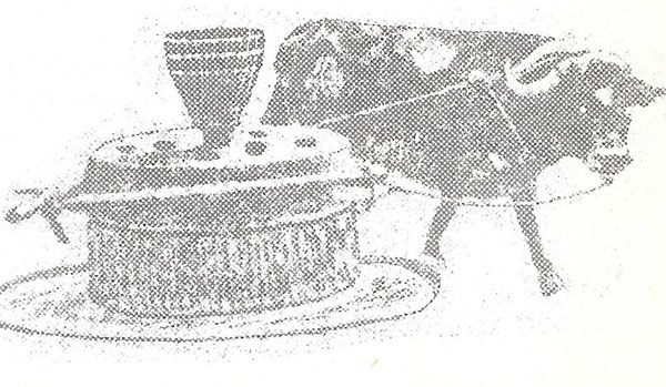
There were many bull and horse powered mills in earlier days.
Bilyeu’s grist mill, and West and Blyze’s grist mill were early enterprises on the Big Tavern creek, followed by Branham’s mill, Stephen’s mill, Bray’s mill, Golden’s mill, and Slawson’s mill before the Civil War. Pack’s mill was situated by a big spring on Humphrey’s creek as early as 1845.
Brockman’s saw mill on the Saline creek, at Sulphur Spring, was the first enterprise of its kind in Miller county run by water power.
Early grist mills on the Grand Auglaize included Johnston’s, Sarter’s, Bowlin’s, Foxes, Coxen’s, Scagg’s and Salsman’s.
Bowlin’s mill was located south of present day Kaiser, on the Grand Auglaize creek, Benjamin Franklin Bowlin, proprietor. He was the 10th son of an Irish father and German mother who arrived in Virginia about 1780, later moving into Tennessee and Kentucky.
Benjamin was born April 22, 1808, in Barren county, Kentucky, and when of age, married Sophia Jane Dodd of Tennessee. Shortly after marriage they migrated into north Missouri, but being hill’ folk soon removed from the place to Auglaize creek in Miller county where wild game, water, and timber were in abundance.
Benjamin erected a two story, puncheon log house, building a mill for the grinding of grain, using water from the Wet Auglaize creek for driving the milling machinery.
On October 16, 1854, Scott Strong and William Salsman petitioned the Miller Circuit Court for a writ of ad quod domnum, and being granted, under seal of the Court, was issued to the Sheriff of Miller county.
Having declared themselves the legal owners of a certain tract of land, being the E ½ of the SE ¼ of Section 26, Township 39N, Range 15W, traversed by a water course known as the Wet Glaize, they proposed placing an earthen fill across the stream seven feet in height for operating a grist mill, running two sets of burrs, and a saw mill, running one saw.
Sovereign Popplewell, the legal owner of a farm adjoining the proposed mill-dam’ site, informed the Court that blocking of the water-course would inundate a reasonable portion of his farm, damaging the land, his garden, orchard, out-buildings, and mansion house, generally endangering the health of himself, his family, and the entire neighborhood.
To inquire into the matter, as required by law, the Sheriff empaneled a jury of twelve men, -Tolbird Bass, Daniel Etter, G. Robinson, Joseph Golden, John Graham, Cyrus Vandensen, A.T. Wilson, G. Breedlove, Wm. Kuykendall, William DeGraffenreid, James Waddle, and George Robinett.
Meeting at the site, after hearing every question, the jury reported:
“We the jury agree and say, First: What damages each proprietor will sustain by reason of inundation consequent upon the erection of this dam as proposed? We the jury say none. Second: Whether the mansion house of any such proprietor or the out-houses, curtilages or gardens thereto immediately belonging or orchard will be overflowed thereby? We the jury say not. Third: Whether and to what extent navigation ordinary and fish of passage will be obstructed by such erection and whether and by what means the same may be prevented or diminished? Damages none. And Fourth: Whether the health of the neighborhood will be materially annoyed in consequence of such erection? We say none.”
Erecting the dam, and raising a mill house, Scott Strong and William Salsman installed milling machinery, later adding a saw, doing an extensive grist and lumber business before the Civil War.
William Salsman also purchased John Johnson’s grist mill in Camden county, with Marcus L. Halstead joining the enterprise as a partner in 1856.
In February, 1855, Jesse Ratcliffe petitioned the Miller Circuit Court for a writ of ad quod domnum, which was granted under seal of the Court, and issued to the Sheriff of Miller county.
Ratcliffe’s petition declared himself the legal owner of a certain tract of land situated in Miller county, purchased by him from the United States, described more particularly as the N ½ of Lot No. 2 of SW ¼ of Section 7, Township 42N, Range 15W, through which a water course passed at or near the Southeast corner, known as the South Moreau creek.
Ratcliffe proposed erecting a dam seven feet and six inches in height across this creek to run a grist and saw mill, the houses and machinery to be erected on the easterly side of the stream. John Comes, a resident of Morgan county, being the owner of the land on the westerly side of the stream, made action by the Court necessary in order for him to attach his dam upon it.
Twelve disinterested persons, summoned, sworn by the Sheriff, and empaneled as a jury, met at the proposed site on April 8, 1856, inquiring upon the matters touched by the petition.
Afterward, Ratcliffe’s mills commenced running, and continued in operation many years.
On March 11, 1857, John Humes of Pleasant Mount, entered into a co-partnership agreement of five years’ duration with Daniel Cummings and Emanuel Godlove of Tuscumbia, for the purpose of erecting a steam saw and grist mill, and such other buildings, and machinery, as they deemed expedient, under the name and style of John Humes and Company.
The agreement stated “John Humes shall devote his undivided time and attention to the business of the concern, erecting the necessary buildings, operating the machinery, & with Emanuel Godlove and Daniel Cummings, each furnishing one hand.”
A carding machine house of three stories, the tallest building in Miller county was erected at Pleasant Mount, and a manufacturing complex, including a saw and grist mill, constructed at Tuscumbia.
John Humes having erected, and successfully operated, the first grist mill run by steam power in the county, was a capable engineer and an experienced mechanic. His grist mill’ engine at Pleasant Mount, first running in 1853, was now driving the carding machinery.
Upon completion of the company’s enterprises, John Humes sold his undivided third part of the steam saw and grist mill at Tuscumbia, including the engine, boiler, machinery, timbers, teams, wagons, wheels, ways and appurtenances to Daniel Cummings and Emanuel Godlove. In turn, Cummings and Godlove sold to Humes their interests in the carding machine house at Pleasant Mount.
Before the Civil War, Cummings & Godlove at Tuscumbia, Humes & Alcorn at Pleasant Mount, were unable to keep abreast for want of time, with the grinding of their customers wheat and corn; the carding machinery at Pleasant Mount running day and night in season.
In this era, the making of clothing was completely performed in the homes, with wool and cotton made into yarn or thread by means of the common hand cards and spinning wheels, then woven into cloth with nimble fingers rapidly twisting and manipulating knitting needles, or woofed and warped upon hand looms.
The carding machines, run by steam or water power, gave an impetus to this work by carding hanks of raw wool with speed and precision, lightening the work of many women, and making home life for them more enjoyable, if only a little so.
At the beginning of the Civil War, carding machines were running at Pleasant Mount, Golden’s mill in Osage township, and at Silas Capps’ mill near Capps’ Landing by the Osage river.
Distilleries were usually associated with the milling enterprises, making snake-bite medicine of good quality, and in quantity.
Something must be written about the unfortunate and destitute inhabitants in this period of history.
Until, and for some time following the Civil War, the County Court retained sole jurisdiction over orphan children, the feeble-minded, lunatics, and other inhabitants driven by death, illness, or other disposition from useful employment to modes of helpless dependency.
Orphan children were called before the County Court, and in person, if of tender age enough, permitted to select their own guardians, usually choosing relatives whom they liked better than others, and by whom, it was believed, would be most humanely treated. Other children, less fortunate, were bound to some person under a system of apprenticeship to learn a trade, until becoming of age.
On July 24, 1837, the first child in Miller county apprenticed to learn the trade of a farmer was bound under the statutory prerogatives of the County Court, in the following manner: “It is ordered by the Court here that James Nobles of the age of three years on the twentieth day of September, last, the son of Polly Nobles of Miller County, be placed and bound to James Reed of the same place, to learn the trade of a farmer, which he the said James Reed now follows, and with him to dwell until the said James Nobles shall have attained the age of twenty-one years.”1
On November 7 of the same year, the County Court ordered “Joshua D. Cockran of the age of twelve years on the twenty-sixth day of July, last, the son of Edward Cockran, late of the State of Mississippi, deceased, be placed and bound as an apprentice to Abraham Castleman of the County of Miller in the State of Missouri, to learn the trade of a farmer, which he the said Abraham Castleman now follows, and with him to dwell until the said Joshua D. Cockran shall have attained the full age of twenty-one years which will be on the twenty-sixth day of July in the year of our Lord eighteen hundred and forty-six.”2
Insane persons, known then as lunatics, were for a long time after the formation of the county much exposed to oppression by the people, their care and services sold by the County Court at public auction, usually to the lowest bidder, under a system little removed from slavery. Most people considered lunacy the work of the devil, while more enlightened inhabitants considered it punishment inflicted by Heaven for personal failures in duties to God.
The following orders by the County Court, in substance, reveal more fully how the authorities assisted citizens in distressed conditions in the earlier days of the county’s history.
“Upon the information of William N. Harrison, Sheriff of this county, it appears to the satisfaction of the Court here that there is at this time residing in the County of Miller a very old and helpless woman by the name of Berner and that she is entirely unable to obtain the necessaries for her support; at it further appears there is also an Idiot residing at James Mason’s in the County of Miller by the name of William Trotter, and that he is entirely incapable of maintaining or taking care of himself; Therefore, it is ordered by this Court that the Sheriff cause the aforesaid old Mrs. Berner and William Trotter to be brought to the Court House in the Town of Tuscumbia on the first day of this Court’s next term, and then and there proceed to let out the aforesaid Mrs. Berner and William Trotter to the lowest bidder for a term of twelve months, first giving notice of the same by putting up three written advertisements in the county, one at Mount Pleasant, one at Elijah Dyers, and one in the Town of Tuscumbia.”3
“It appearing to the satisfaction of this Court a man by the name of Lindsay is residing in this county and that he is unable to labor and has no means wherewith to maintain himself; Therefore, it is ordered by the Court the Sheriff of this county let out said Lindsay to the lowest bidder for twelve months on the first day of the next regular term of this Court, first giving fifteen days previous notice of the time and place of letting by advertisement at one public place in each township in the county. And, it is further ordered, the Sheriff take the person or persons who may bid off said Lindsay, bond and good security in double the amount which he may be bid off at, conditioned they will not mistreat nor ill use said Lindsay, and will furnish good and sufficient course clothing together with food suitable to his age and condition and at the expiration of the twelve months return the said Lindsay to the Court.”4
“Upon information of Thomas W. Whitaker, Sheriff of Miller County, it appears to the satisfaction of this Court there is a female Idiot child residing in Miller County by the name of Kenyon, daughter of Elizabeth Kenyon, and it further appearing the said Elizabeth Kenyon has several other children to maintain besides the aforesaid Idiot and that it is out of her power to maintain all of her children; Therefore, it is ordered by the Court the Sheriff bring or cause to be brought the aforesaid Idiot to the Town of Tuscumbia on the first day of the next term of this Court, and then and there proceed to let out said Idiot to the lowest bidder for the term of twelve months, first giving fifteen days previous notice of the time and place of letting, by advertising the same in one public and known place in each township in the county.”5
A few other orders, given in substance, will suffice here. “William Brockman shall furnish Francis Lindsay, a poor person, two good domestic shirts, two pairs of good flax linen pantaloons, and one pair of shoes, and present his account to this Court for payment.”6
”Ordered the Sheriff let to the lowest bidder at the Court House door forthwith Susan, Ann Eliza, and Elizabeth Runolds, minor heirs of Richard Runolds, deceased, for the term of twelve months from this date.”7
“Now comes Hiram B. Russell into Court with Samuel and Wilson Garrison, two orphan children, twins of the age of ten years on the 13th day of July, 1849, praying to have said children bound unto him to learn the trade of farming; Therefore, it is ordered said orphans be bound unto him until they shall have arrived at the age of twenty-one years.”8
“Now comes William West into Court, delivering Alexander Scott and Mary Scott, two poor children, and thereupon it is ordered by the Court the Sheriff proceed forthwith to let out said children for a term of twelve months to the lowest bidder.”9
Missouri State Lunatic Asylum, Fulton
Erection of the Lunatic Asylum at Fulton, Missouri, commenced in 1847, completed in 1851, afforded more humane treatment for persons suffering lunacy.
Many cases, like the foregoing, were handled by the County Court.
1. County Court Record Book A, page 9
2. Ibid., page 21
3. Ibid., page 92
4. Ibid., page 107, May 5, 1841
5. Ibid., page 114, June 21, 1841
6. Ibid., page 113, June 21, 1841
7. Ibid., page 276, November 2, 1846
8. Ibid., page 431, Aug. 6, 1849
9. Ibid., page 444, Nov. 5, 1849
Now it must be written persons able to perform manual labor, and not doing so, were often charged with vagrancy. Once indicted they were hailed into court, and if found guilty, heavily fined. Occasionally insignificant trifles were presumed reason enough for imposing upon someone the charge of vagrancy, for indolent persons, in this era, were rudely censured by the inhabitants.
Back to Top

|
P.O. Box 57 Tuscumbia, MO 65082 http://www.MillerCountyMuseum.org © 2014 - Miller County Historical Society millercountymuseum@att.net |
|
|
Graciously hosted by:
|
|